
The best motorcycle roads in Scotland are not confined to one famous loop. Motorcycle touring here rewards riders willing to leave the North Coast 500 for a day: a single-track pass steeper than anything else in Britain, a glen that dead-ends at the edge of the Cairngorms, an island road that needs a ferry to reach it. This guide ranks ten routes across the country for motorcycle riding, judged on the quality of the riding first, the scale of the journey second, and fame only as a tiebreak. Scotland’s most famous single stretch of tarmac is here too, but not where you might expect it.
In this guide:
Contents
10. The Golden Road: B887, Isle of Harris
Distance: around 23 miles (38 km), Tarbert to Rodel
Best for: remote island touring, coastal scenery, low traffic
Best time: April to September
The Route:
It opens the countdown because it is the most remote entry in the guide, and reaching it is part of the ride: the Golden Road only exists on the far side of a ferry crossing to the Outer Hebrides. It runs down the rocky east coast of South Harris, named either for its construction cost or, according to local historian Bill Lawson, for being the island’s first sealed road after the war. The road is narrow, undulating and lined with passing places rather than corners, threading between lochans, crofts and a scattering of small galleries and weaving studios through Plocrapol, Scadabay and Grosebay before rejoining the main road near Lacklee. Reviews of it genuinely split: some riders call it the best road on Harris, others say the scenery elsewhere on the island is just as good without the single-track slog. Both are right. What is not in dispute is the landscape either side of it, closer to a moonscape of bare rock and small lochs than anywhere else in this guide.
Ride it from Tarbert to Rodel so the road builds gradually rather than throwing you straight into the tightest section, and so you finish at Rodel’s twelfth-century St Clement’s Church, one of the most important medieval buildings in the Hebrides. Passing places are frequent but not constant, and blind hills and bends are common, so keep your speed down and be ready to reverse. There is no fuel on the road itself: fill up in Tarbert before you leave. Weather turns quickly this far west, and low cloud can sit on the road for hours even when the rest of Harris is clear. Ferries connect Tarbert to Uig on Skye and to Berneray in the Uists, so this road works well as one leg of a longer island-hopping trip rather than a there-and-back.
Scenic tip:
Go offline before you leave Tarbert. Mobile coverage on the Golden Road is patchy at best and drops out completely in places, and there is very little passing traffic to ask for directions if you take a wrong turn onto one of the unmarked croft tracks. Download the Harris section while you still have signal at the ferry terminal.
Ride this route:
Start (Tarbert): 57.8982, -6.8067
End (Rodel): 57.7448, -6.9665
Or get the whole route free here, with Scenic: https://scenicapp.space/route/DMpJmNtW
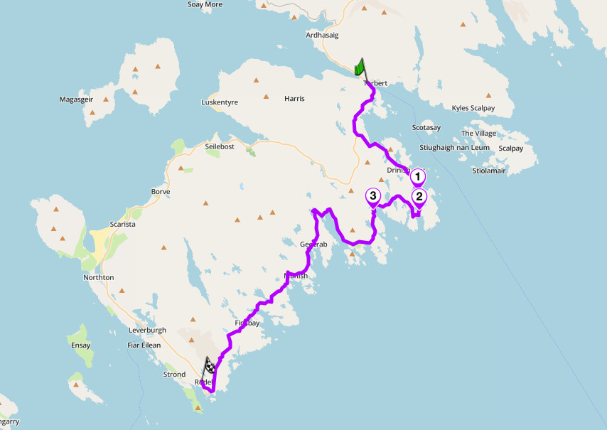
The Golden Road, B887, Isle of Harris
9. Glen Clova: B955, Angus Glens
Distance: around 37 miles (60 km) round trip, Kirriemuir to Glendoll and back
Best for: single-track touring, underrated glens, dead-end riding
Best time: April to October
The Route:
Glen Clova is the best known of the five Angus Glens and the least written about outside walking guides, which makes it the clearest underrated pick in this guide. The B955 runs north out of Kirriemuir for around 18 miles to Glendoll, where the public road stops at the edge of the Cairngorms and only a footpath continues north towards Deeside. Past Dykehead, the road climbs through the narrow mouth of the glen and past the lonely cottage of Glenarm before the road forks near a picnic site on the riverbank, the site of the old Gella Bridge, demolished in 2008, though the name is still used locally for the crossing point. This is where the genuine loop begins: traffic heading up is expected to keep to the western side of the valley floor and traffic heading back to use the eastern side, so the ride out and the ride back are two different roads rather than the same tarmac twice. Both sides run close to the meandering River South Esk with the glen’s steep sides rising on either flank, and the whole thing dead-ends at Glendoll with nothing beyond it but hill tracks.
Ride up the western side and back down the eastern side, following the glen’s own unofficial system rather than fighting it, since it exists because the roads are single track and this keeps opposing traffic broadly predictable. The return leg passes Rottal, the largest settlement in the glen after Clova itself, a handful of houses and a lodge at the widest point of the valley floor. Fuel and all other services are in Kirriemuir; there is nothing beyond Dykehead, and mobile signal thins out well before Glendoll. Livestock and pheasants on the road are routine here, and the single-track sections have passing places rather than a hard shoulder, so treat blind bends accordingly.
Scenic tip:
Stop at Gella Bridge, roughly halfway up, where a picnic site sits at the point the road crosses the South Esk. It is the natural midpoint to swap from the outbound to the return side of the loop, and it is also the best place in the glen to get out, stretch your legs and look back down the valley you have just climbed.
Ride this route:
Start and end (Kirriemuir): 56.6731, -3.0044
Or get the whole route free here, with Scenic: https://scenicapp.space/route/VwIkGypk
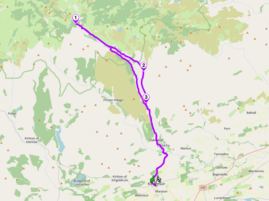
Glen Clova, B955, Angus Glens
8. The Glen Cafe Road: A708, Scottish Borders
Distance: around 35 miles (56 km), Moffat to Selkirk
Best for: flowing Borders touring, low traffic, biker culture
Best time: April to October
The Route:
The Scottish Borders get none of the attention the Highlands do in most motorcycling guides, and the A708 is the clearest argument that they should. Once named by the AA as one of Britain’s most scenic routes, it runs from Moffat through the valley known as the Moffat Water, past the Grey Mare’s Tail waterfall, and along the shore of Loch of the Lowes and St Mary’s Loch to Selkirk. The road is fast rather than technical: rollercoaster changes of camber and gradient rather than tight hairpins, run through open hill country with long sightlines. It is also a genuine biker meeting point rather than a road that merely photographs well: the Glen Cafe on the loch shore is reported drawing sixty or seventy motorcycles on a good summer weekend, entirely under its own reputation rather than any marketing push.
Ride it from Moffat towards Selkirk so the best of the road, the Moffat Water stretch, comes first while you are fresh, and the gentler run past the lochs comes as a wind-down. Fuel and full services are at both Moffat and Selkirk; there is nothing in between beyond the Glen Cafe itself, which is food and drink only. The road is well used by local riders, particularly on weekend afternoons, so expect other motorcycles. For a longer day, the wider Borders Loop continues from Selkirk through Hawick, Langholm and Lockerbie back to Moffat. The Talla and Megget road, a narrow single-track link west from the A708 at Cappercleuch, connects through to the Tweedsmuir hills for riders who want to extend the route.
Scenic tip:
Stop at the Glen Cafe on St Mary’s Loch. It is not a hidden find, it is one of the most established biker stops in the Borders, but that is exactly the point: on a good day it is as much a part of the ride as the road itself, and skipping it means missing the reason half the other riders on this stretch are here.
Ride this route:
Start (Moffat): 55.3348, -3.4406
End (Selkirk): 55.5506, -2.8381
Or get the whole route free here, with Scenic: https://scenicapp.space/route/AaqnMAzo
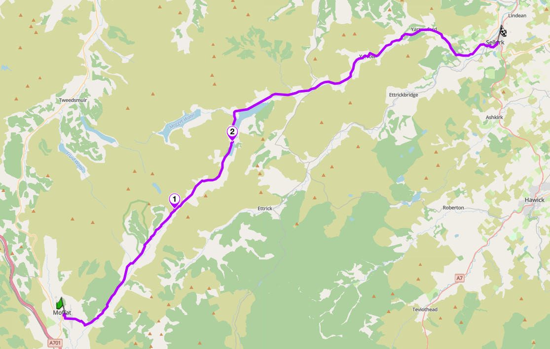
The Glen Cafe Road, A708, Scottish Borders
7. Duke’s Pass: A821, the Trossachs
Distance: around 26 miles (42 km) loop, Callander to Aberfoyle and back
Altitude: 240 m at the summit of the pass
Best for: technical hairpins, short high-intensity loops, local biker culture
Best time: April to October
The Route:
The pass itself is only around seven and a half miles long, well short of this guide’s minimum, so the route here builds it out into a proper loop: out from Callander on the A84 to Kilmahog, over the Duke’s Pass on the A821 through Aberfoyle, then back to Callander on the A81. Built in 1885 by the Duke of Montrose to serve his estate, the A821 is consistently named by riders as one of the most demanding short roads in Scotland: blind crests, tight bends with no run-off in places, and a section by Loch Achray where more than one rider has warned that an inattentive line puts you in the water rather than around the bend.
Ride it from Callander to Aberfoyle first, which several experienced local riders name as their preferred direction, then close the loop back to Callander on the calmer A81. Coach and camper traffic builds through the day, especially around the Three Lochs Forest Drive turn-off, so an early start or an early-evening run around 18:00 to 20:00, when day-trippers have gone for tea, gets you the road with far less traffic. Surface is generally good but gravel is reported on some bends near the forestry park entrance, so treat every blind corner as a fresh decision rather than a known line. Fuel and full services are at Callander at both ends of the loop; Aberfoyle has fuel and cafes at the midpoint.
Scenic tip:
Ride the loop early or late in the day rather than midday. More than one local rider reports simply riding to the far end and turning around rather than bothering with a longer loop, which says as much about the road as any review could. If you only have time for one direction, ride Callander to Aberfoyle: several riders name it as their preferred way to take the pass.
Ride this route:
Start and end (Callander): 56.2452, -4.2117
Summit (Duke’s Pass): 56.2029, -4.3910
Or get the whole route free here, with Scenic: https://scenicapp.space/route/DxzOAzyY
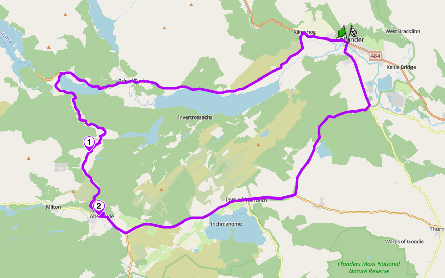
Duke’s Pass, A821, the Trossachs
6. The Lecht and the Snow Roads: A939, Cairngorms
Distance: around 60 miles (97 km), Nairn to Ballater
Altitude: 646 m at the Lecht summit
Best for: high remote riding, alternative route to the A9, changeable weather
Best time: May to September
The Route:
The A939 is part of the Old Military Road built after the 1745 Jacobite rising, and it crosses four separate summits between the Moray coast and Royal Deeside: Dava Moor, Bridge of Brown, the Lecht itself at 646 m, and the Gairnshiel summit. The Lecht section, between Tomintoul and Cock Bridge, is regularly the first road in Great Britain to close for snow each winter, which tells you most of what you need to know about the terrain even in summer. The fast moorland stretches are broken up by genuinely tight, hilly corners, and it is consistently named as a preferred alternative to the A9 for anyone travelling between the Highlands and the north-east coast.
Ride it either direction; it works as well north to south as the reverse. Wind is the named hazard on the open moorland sections, more than traffic, and more than one rider has reported days where standing upright on the exposed stretches is genuinely difficult. Snow gates operate at Cock Bridge and Tomintoul and can close the road with little notice outside summer. Fuel is available at Nairn, Tomintoul and Ballater; the middle section over the passes has nothing. The road forms the backbone of the signed Snow Roads tourist route, so expect campervans and cyclists in summer alongside the usual local traffic.
Scenic tip:
Force curvy routing if you’re coming from the Moray coast. The A9 is the faster line south, and a distance-optimised route will suggest it by default. Overriding it for the A939 is the entire reason to take the four summits instead of the motorway.
Ride this route:
Start (Nairn): 57.5869, -3.8729
Summit (the Lecht, Cock Bridge): 57.2006, -3.2480
End (Ballater): 57.0492, -3.0365
Or get the whole route free here, with Scenic: https://scenicapp.space/route/WPEMPoZT
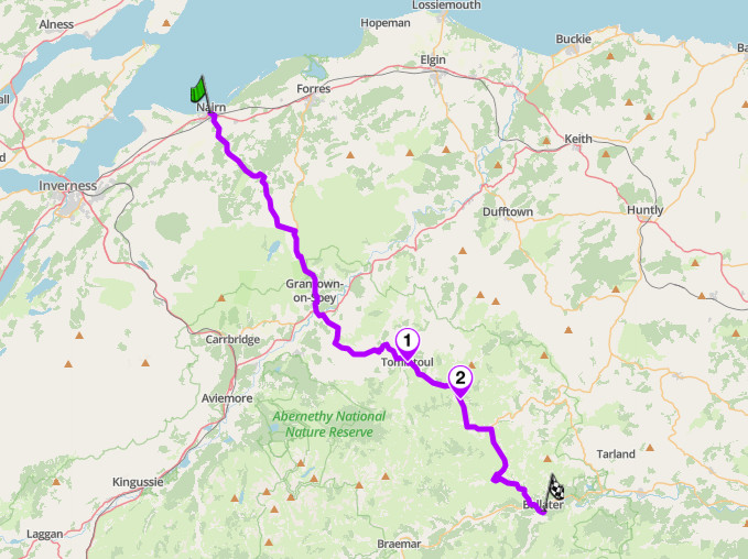
The Lecht and the Snow Roads, A939, Cairngorms
5. The Trotternish Loop: A855 and A87, Isle of Skye
Distance: around 42 miles (67 km) loop from Portree
Best for: coastal loops, dramatic scenery, island touring
Best time: April to September
The Route:
This is the one true loop in the guide: out on the A855, back on the A87, two different roads rather than the same tarmac twice. The peninsula is defined by the Trotternish escarpment, a 20-mile landslip, the largest in Britain, that has thrown up the Old Man of Storr and the Quiraing along the way. The A855 narrows to single track for a stretch north of Portree and again on the final approach to Uig, while the A87 on the return leg is wider, faster and sweeping, a genuinely different riding experience from the road you rode out on.
Ride it anticlockwise, out on the A855 and back on the A87, so the tighter coastal single-track riding comes first and the faster return leg brings you back into Portree at a pace that matches the end of the day. Camper vans are the defining hazard on the single-track sections, particularly around the Old Man of Storr car park and the Quiraing turn-off, where cars stop without warning for photographs. Uig has fuel and is also the ferry port for the Outer Hebrides, so this loop connects naturally onward to Harris and the Golden Road if you are island-hopping.
Scenic tip:
Use Explore to build round trips out of Portree rather than treating the Trotternish Loop as the only plan for the day. Skye has good roads radiating out in several directions, including the A863 to Dunvegan and the road out towards Elgol, and Explore will find worthwhile detours a straight map would not suggest.
Ride this route:
Start and end (Portree): 57.4128, -6.1943
Or get the whole route free here, with Scenic: https://scenicapp.space/route/usItBgag
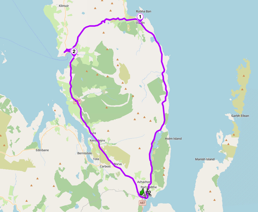
The Trotternish Loop, A855 and A87, Isle of Skye
4. Glenshee and Royal Deeside: A93, Cairngorms
Distance: around 50 miles (80 km), Blairgowrie to Ballater
Best for: long flowing mountain riding, low traffic, day-long touring
Best time: April to October
The Route:
This road has been compared to the Alps, which is a high bar for a road that never leaves mainland Britain. The A93 climbs out of Blairgowrie through increasingly open country to the Spittal of Glenshee, crosses the Cairnwell Pass into Glenshee ski area, and drops into Royal Deeside through Braemar and Balmoral to Ballater. The character shifts as it goes: forested and twisting in the south, exposed and mountainous around Spittal of Glenshee, then opening into the wide glacial strath of the Dee for the run into Ballater. Traffic is reported as consistently light outside the winter ski season, and the surface is well regarded even by Highland-road standards.
Riding it from Blairgowrie to Ballater makes the climb through the forested lower glen build naturally into the high, open riding around Glenshee. Winter brings ski traffic to the Spittal of Glenshee car parks, but outside the snow season the road carries little beyond local traffic, tractors and the occasional slow-moving tourist. There is a snack van reported just past Old Scone before Blairgowrie for an early coffee. Caution is advised after hard winters when snow ploughs can leave the road surface rougher than usual on the high section.
Scenic tip:
Stop at the Spittal of Glenshee for a proper break. Many name it as the road’s best food stop, and it sits at the natural midpoint between the forested southern section and the open moorland run over the Cairnwell, making it the right place to pause before the character of the ride changes.
Ride this route:
Start (Blairgowrie): 56.5901, -3.3386
End (Ballater): 57.0455, -3.0351
Or get the whole route free here, with Scenic: https://scenicapp.space/route/BFnnPOIz
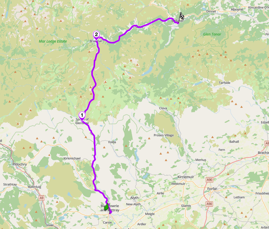
Glenshee and Royal Deeside, A93, Cairngorms
3. Rest and Be Thankful and Kintyre: A83, Argyll
Distance: around 95 miles (153 km), Arrochar to Campbeltown
Altitude: 245 m at the Rest and Be Thankful summit
Best for: scenic pass riding, peninsula touring, long-day journeys
Best time: April to October
The Route:
The A83 does two different jobs in one road, which is why it earns a place above several shorter, punchier entries in this guide. It opens with the Rest and Be Thankful, a modest 245 m pass between Glen Croe and Glen Kinglas named for the words inscribed on a stone by the soldiers who built the original military road in 1753. It is a genuinely scenic climb rather than a technical one, with the Arrochar Alps and the distinctive peak of the Cobbler dominating the view. From there the road runs the length of Loch Fyne and down the Kintyre peninsula to Campbeltown.
Check the current status of the Rest and Be Thankful before you travel. The pass has been under active landslide mitigation works since 2020, with temporary signals in place during works periods through 2026. The road is a working route for local traffic and freight as well as tourists, so expect slower vehicles on the narrower Kintyre sections and plan overtakes accordingly.
Scenic tip:
Stop at the summit itself, and look for the stone. It’s inscribed with the pass’s own name, first cut in 1748 by the soldiers who built the road and thankful enough to have made it that they carved the mood into rock. From the same spot you can look down into Glen Croe at the original military road still visible on the valley floor, engineered in the 1740s. Few viewpoints in this guide show three centuries of road-building stacked in a single glance.
Ride this route:
Start (Arrochar): 56.1967, -4.7453
Summit (Rest and Be Thankful): 56.2267, -4.8561
End (Campbeltown): 55.4219, -5.6160
Or get the whole route free here, with Scenic: https://scenicapp.space/route/FlPQmWNn
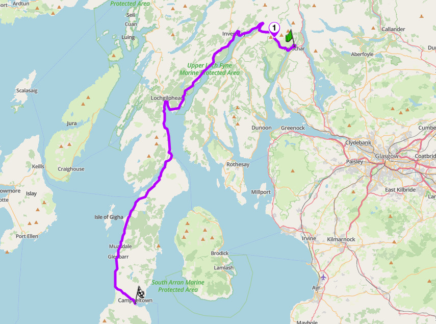
Rest and Be Thankful and Kintyre, A83, Argyll
2. Glen Coe and Rannoch Moor: A82, Highlands
Distance: around 50 miles (80 km), Tyndrum to Fort William
Best for: iconic Highland scenery, benchmark touring, first-time Scotland riders
Best time: April to October
The Route:
Members of the UK motoring group Boundless voted the A82 through Glen Coe the greatest stretch of road in the British Isles, and it is the road most people picture when they imagine riding in Scotland. It earns the number two spot rather than the top one deliberately: reviews of the road itself, rather than the view from it, describe wide, well-surfaced sweepers that reward confident riding without demanding technical skill, and the appeal here is the scenery rather than the cornering. That is not a criticism. The road climbs out of Tyndrum past Bridge of Orchy, crosses the exposed high plateau of Rannoch Moor with its granite boulders and dark lochans, then drops into Glen Coe past the pyramidal peak of Buachaille Etive Mor guarding the entrance, deeper into the glen where the Three Sisters rise on one side and Aonach Eagach on the other, before running down to Fort William beneath Ben Nevis.
This is a major through route as well as a scenic one, so expect coaches, campervans and commercial traffic, particularly in July and August. The Green Welly Stop is the well-known refuelling point. Deer on the road are a genuine hazard reported specifically on this stretch, particularly at dawn and dusk. The Clachaig Inn, a mile off the main road at Glencoe, is a long-standing stop for riders and walkers alike.
Scenic tip:
Stop at the layby above Loch Tulla, just after Bridge of Orchy, where red deer are commonly seen grazing the banks below and the road ahead across Rannoch Moor is laid out in front of you. It is the best place in the guide to see the scale of the moor before you ride across it, rather than only appreciating it once you are already in the middle of it.
Ride this route:
Start (Tyndrum): 56.4360, -4.7128
End (Fort William): 56.8199, -5.1058
Or get the whole route free here, with Scenic: https://scenicapp.space/route/BANWeaGJ
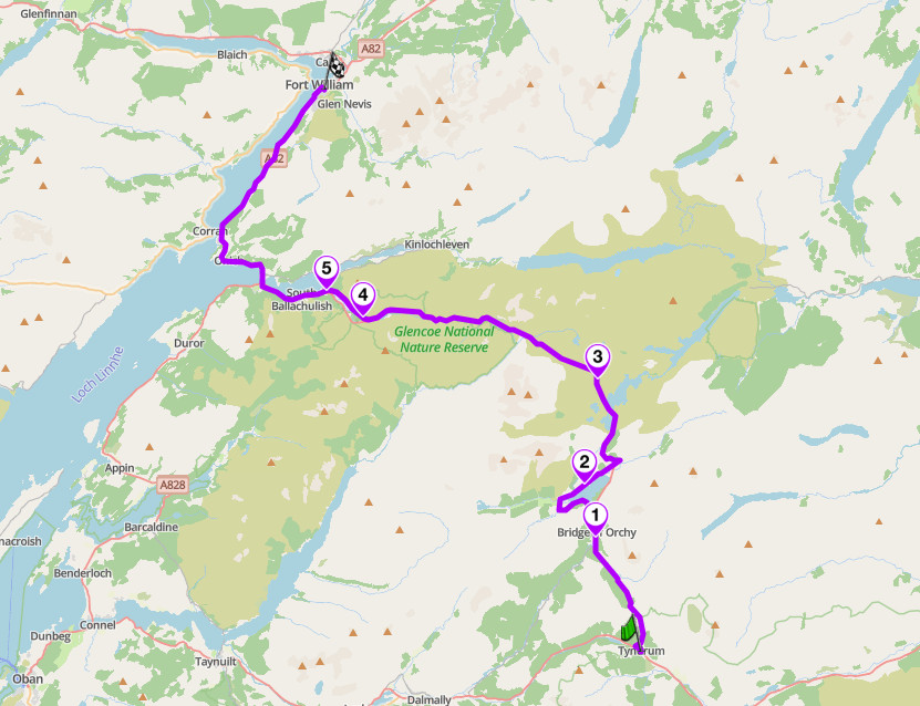
Glen Coe and Rannoch Moor, A82, Highlands
1. Bealach na Ba and the Applecross Coast: Lochcarron to Shieldaig, Wester Ross
Distance: around 42 miles (67 km), Lochcarron to Shieldaig via Applecross
Altitude: 626 m at the summit of the Bealach na Ba
Best for: technical alpine-style riding, single-track mastery, the best pure corners in the guide
Best time: May to September
The Route:
Bealach na Ba is the closest Britain comes to an Alpine pass, rated on the riding itself, which is why it takes the top spot. Engineered in 1822, the single-track road climbs from sea level to 626 m in a little over six kilometres, gradients touching 20 percent, no barrier on the exposed sections: the steepest sustained ascent in the UK. From Lochcarron the road runs to Tornapress, then climbs through several corries to a summit plateau with views to Skye and the Outer Hebrides. The descent into Applecross is as demanding as the climb. From there the road hugs the coast north through Fearnmore to Shieldaig, the right way to complete the peninsula: the hard pass one way, a quieter coastal road the other.
There are no barriers on the pass and few passing places on the tightest hairpins, so this is not a road for poor visibility or a nervous pillion. Fuel does not exist on the pass, and Applecross’s own pump keeps limited hours, so fill up in Lochcarron first. Snow gates close the pass for weeks at a time in winter. Since it forms part of the North Coast 500, expect heavy campervan traffic in July and August. The coastal road north from Applecross carries far less traffic, with sheep and blind bends the main hazards, and views east across Loch Torridon among the best in the guide.
Scenic tip:
Stop at the summit car park before you start the descent into Applecross. It is the highest point on the route and the best view in the entire guide for the effort required to reach it: Skye, the Cuillin ridge, and on a clear day Harris and Lewis laid out across the water. Do not linger if cloud is coming in, since visibility here can drop to a few metres within minutes.
Ride this route:
Start (Lochcarron): 57.3974, -5.5035
Summit (Bealach na Ba): 57.4189, -5.7087
End (Shieldaig): 57.5229, -5.6507
Or get the whole route free here, with Scenic: https://scenicapp.space/route/qDpddrCL
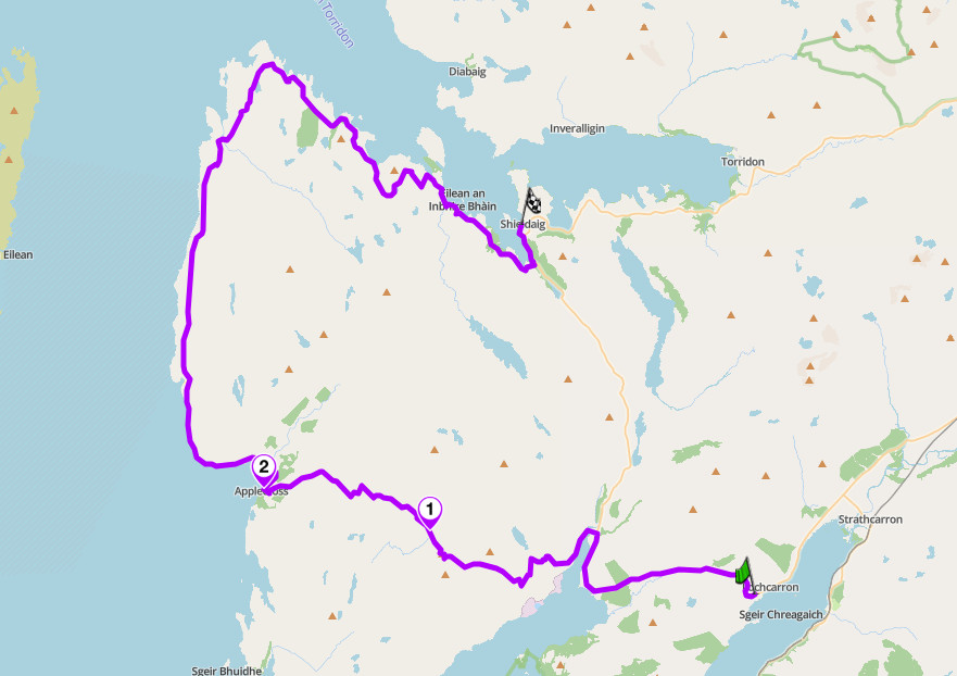
Bealach na Ba, Applecross, Wester Ross
Planning Your Ride
Scotland’s riding season runs roughly April to October, and it is shorter and less predictable at altitude than the calendar suggests. The Lecht and Bealach na Ba both carry snow gates and can close for weeks at a time outside summer, with closures announced at short notice rather than on a fixed date. Weather changes fast at altitude even in July: cloud can drop visibility on an exposed summit to a few metres within minutes, so carry layers and do not push on if conditions turn on a pass with no barriers.
The A83 at the Rest and Be Thankful has an active history of landslide closures and is currently subject to ongoing engineering works; check Traffic Scotland before you travel rather than assuming the road is clear. Deer are a genuine hazard on several of these routes, particularly the A82, and are worst at dawn and dusk. Midges are a serious practical nuisance from late spring through summer, especially near lochs and in the glens; fuel stops and photo stops both go faster if you keep moving.
Ferries matter for two of these routes. The Golden Road requires a crossing to the Outer Hebrides, and the Trotternish Loop connects naturally onward to Harris via the Uig to Tarbert ferry, so the two make sense as a combined island trip. Book ferry crossings ahead in summer.
If you already have a route built elsewhere, Scenic’s Import handles Google Maps URLs, GPX, KML, KMZ, GDB and ITN files, so a route shared by a riding club or a tour operator arrives whole rather than needing to be rebuilt from scratch. Use Go offline on the Golden Road, Glen Clova and Bealach na Ba especially, since mobile coverage is unreliable on all three.
Where to base yourself
Fort William. The best-connected base for the northern half of this guide. Glen Coe, Rannoch Moor and the road on to Skye are all within reach, and the town has full services, fuel and a wide choice of accommodation.
Portree. The natural base for the Trotternish Loop and for onward travel to the Outer Hebrides via the Uig ferry. Skye’s largest town, with full services and a working harbour.
Callander. Central for Duke’s Pass and a good stop for anyone approaching the Highlands from the central belt. A well-established Trossachs tourist town with plenty of accommodation.
Moffat. The natural base for the A708 and the wider Scottish Borders, roughly equidistant from Glasgow, Edinburgh and Carlisle, with a good choice of pubs and places to stay.
Lochcarron. The starting point for the Bealach na Ba and the natural base for exploring the Applecross peninsula, with fuel, shops and a range of accommodation on the shore of Loch Carron.
Frequently asked questions
What is the best motorcycle road in Scotland? On riding quality specifically, independent sources consistently rate Bealach na Ba above every other road checked for this guide, including the more famous A82 through Glen Coe. The A82 wins on fame and scale, Bealach na Ba wins on the actual cornering, which is why this guide ranks the latter first.
When does Bealach na Ba close? It varies year to year rather than following a fixed date. Snow gates operate at both ends of the pass, and closures of several weeks are not unusual once winter weather sets in. Check conditions locally before you travel, particularly outside the May to September season.
Do I need to book ferries in advance? Yes, if your route includes the Outer Hebrides. The Uig to Tarbert crossing connecting Skye and Harris, used to link the Trotternish Loop and the Golden Road, sells out in summer.
Which of these routes is hardest? Bealach na Ba, by a clear margin. Single track throughout, gradients up to 20 percent, no barriers, and a genuine risk of meeting oncoming traffic on a blind hairpin. Duke’s Pass is a distant second for technical demand, though far shorter.
Is the Rest and Be Thankful currently open? Yes, but it’s been under active landslide mitigation works since 2020, with temporary signals in place during works periods through 2026. The Old Military Road alongside the main road serves as a convoy-controlled diversion when landslides or hillside conditions require it. Check Traffic Scotland’s current notices before you travel, since the works schedule changes through the year.
What about midges? They are a genuine nuisance rather than a myth, worst near still water and in sheltered glens from late spring through summer. They are not dangerous and do not affect riding once you are moving, but they will find you the moment you stop for a break.
Where does the North Coast 500 fit into this guide? Its most famous single stretch, Bealach na Ba, leads this guide outright. The rest of the NC500 loop is a broader touring route combining many roads rather than a single ranked entry, which is why it is not listed separately here.
Scenic Premium gives you turn-by-turn navigation with a rider-focused display you can customise, global offline maps, and automatic curvy routing that finds the mountain pass rather than the valley shortcut. On three of the routes above there is no reliable mobile signal for long stretches, which is the case for having the maps on the phone rather than in the cloud.
If you go, tag us and use the hashtag #ridewithscenic for your chance to win a free Scenic t-shirt.
You’ve made it to the end of the article! At Scenic we like to reward people who plan their trips properly. If you’re not already a premium member, use this code to get 20% off your first year of Scenic Premium: ScenicBlog20


