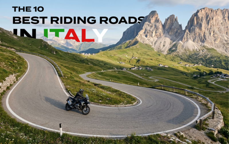
Italy has more rideable variety per square kilometre than anywhere else in Europe. The best motorcycle roads in Italy run from the 2,757-metre hairpins of the Stelvio Pass to the clifftop ledge of the Amalfi Coast, with Dolomite spires, Tuscan vineyards, and Sardinian canyon roads in between. Motorcycle touring in Italy means Alpine passes that close in October, coastal roads that are impassable in August, and espresso stops that turn a 3-hour ride into a 5-hour day. Motorcycle riding in Italy rewards the rider who plans around seasons, avoids weekends on the famous roads, and knows where to fuel up before the next pass.
This guide covers 10 routes across the country. Alps, Dolomites, lakes, coast, Tuscany, islands. Each one verified, each one worth the flight.
In this guide:
Contents
1. Stelvio Pass — SS38, South Tyrol/Lombardy
Distance: 45 km (Prato allo Stelvio to Bormio)
Altitude: 2,757 m
Hairpins: 48 (north/Trafoi side), 36 (south/Bormio side)
Best for: Bucket-list riding, Alpine scenery, technical hairpins
Best time: June to early October (weather dependent)
The Route:
The Stelvio Pass is the highest paved mountain pass in the Eastern Alps and the road that put Italian motorcycle touring on the global map. Built between 1820 and 1825 by the Austrian Empire to connect Lombardy with Austria, the route has changed very little since. The northern ascent from Prato allo Stelvio via Trafoi features 48 numbered hairpin bends climbing through pine forest, then breaking above the treeline into a landscape of glaciers, rock walls, and the Ortles massif at 3,905 m. The southern descent to Bormio drops through 36 hairpins via the Braulio Valley, with a series of short, dark, unlit tunnels carved into the mountainside. Jeremy Clarkson called it “15 miles of asphalt spaghetti draped on an Alp.” He was not wrong.
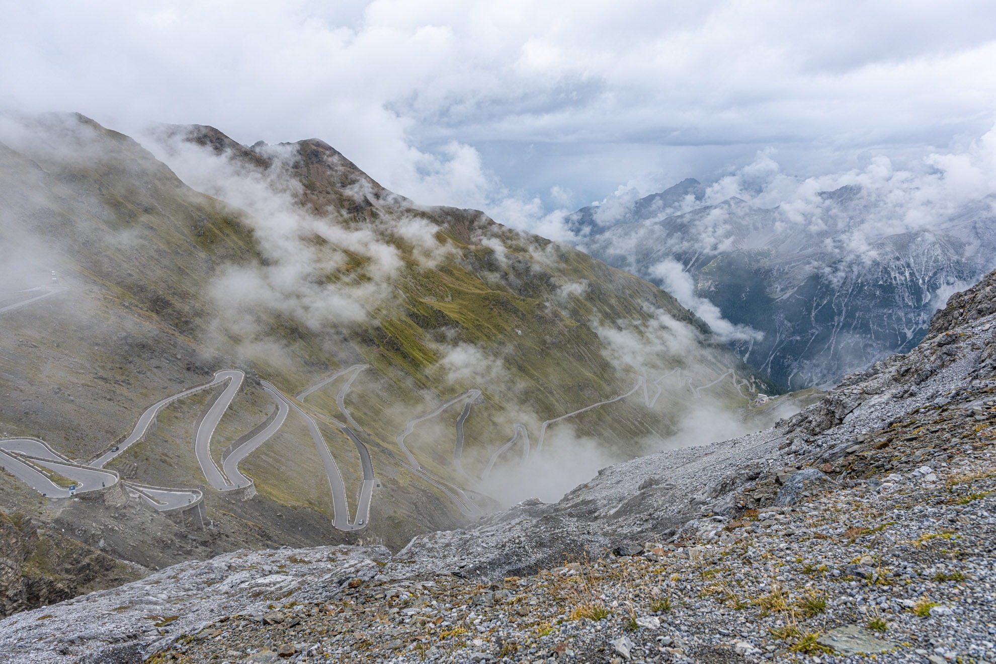
image credit – our wonderful @LNR – LNRmoto.com
Ride from Prato allo Stelvio (north) to Bormio (south). This direction gives you the iconic 48-hairpin wall on the ascent, where you can see the switchbacks stacking above you. The descent through the Braulio tunnels is more dramatic from above. Arrive before 9 AM or after 5 PM in summer to avoid tour buses, campervans, and cyclists. The pass gets extremely busy on weekends between July and August. Many hairpins must be taken at 30 km/h or less. The road is narrow in places and does not always accommodate two vehicles. Temperatures at the summit rarely exceed 10°C even in summer: bring layers. The tunnels on the Bormio side are unlit and narrow; use your headlight and stay right. Fuel is available in Prato allo Stelvio and Bormio. From the summit, the Umbrail Pass crosses into Switzerland on a road that is even narrower and less trafficked, our ambassador Leonoor likes to call this the ‘mini Stelvio without traffic’.
Scenic tip:
At the summit, skip the souvenir stalls and walk 200 metres east along the ridge path. The view south down the Bormio hairpins is the one you have seen in every photograph, but from this angle you also see the Ortles glacier directly above. It is the best vantage point on the entire pass and most riders never leave the car park.
Technicality: Expert. Extremely tight hairpins, steep gradients (average 7.4%, max ~12%), narrow tunnels, high altitude, heavy traffic in summer.
Max gradient: 12%
Ride this route:
Start (Prato allo Stelvio): 46.6190, 10.5914
End (Bormio): 46.4683, 10.3714
Summit (Stelvio Pass): 46.5285, 10.4533
Or get the whole route free here, with Scenic: https://scenicapp.space/route/xGASvquy
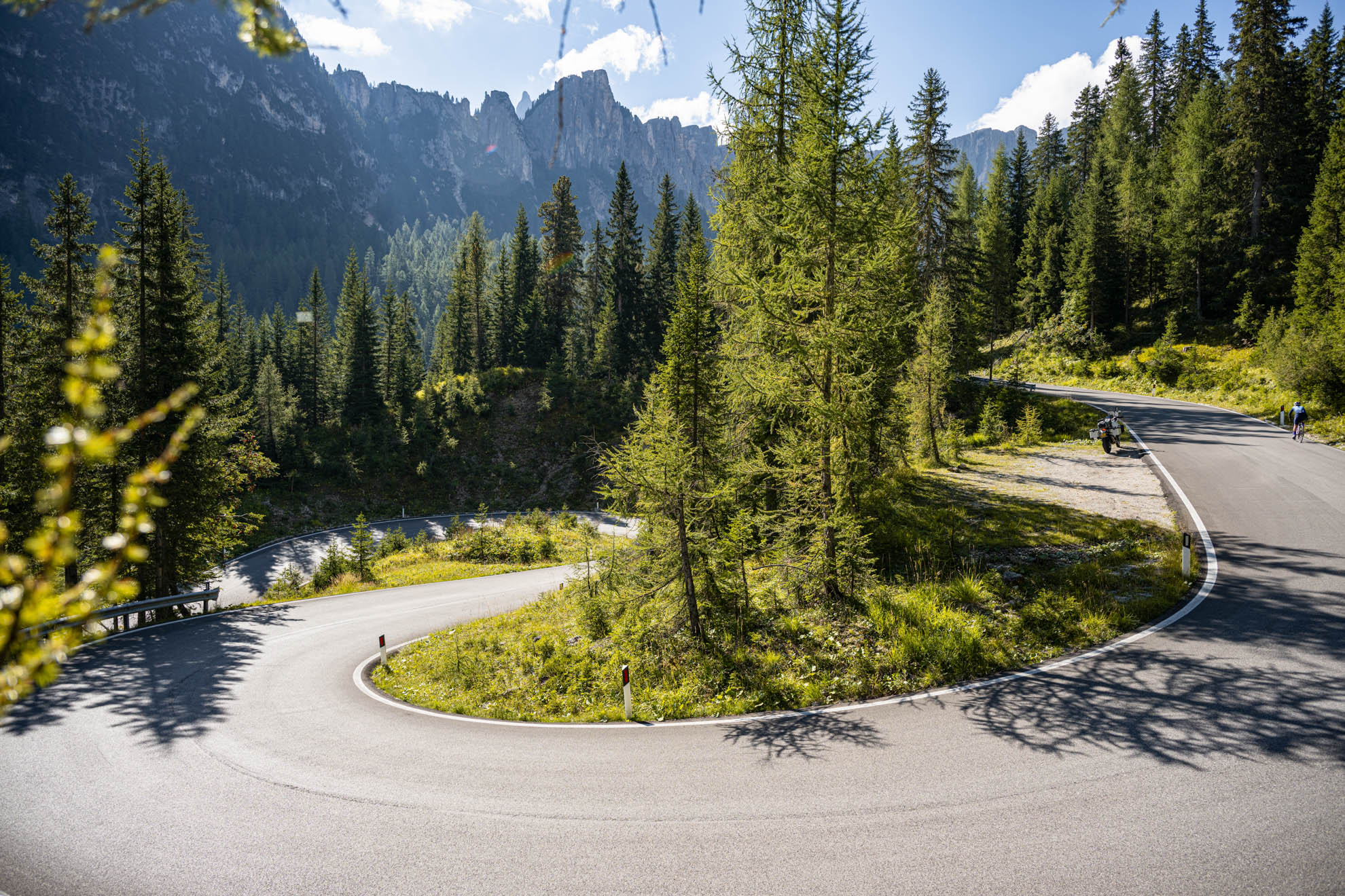
2. Sella Ronda — SS242/SS48/SS243, Dolomites
Distance: 52 km (loop)
Altitude: Passo Pordoi 2,239 m (highest point)
Key passes: Passo Gardena (2,121 m), Passo Sella (2,218 m), Passo Pordoi (2,239 m), Passo Campolongo (1,875 m)
Best for: Dolomite scenery, multi-pass loops, intermediate to advanced riders
Best time: June to September
The Route:
The Sella Ronda is a 52 km loop around the Sella massif in the Dolomites, crossing four passes in a single ride. Each pass has its own character. Passo Gardena opens with 19 flowing hairpins and views of Sassolungo. Passo Sella climbs through 23 switchbacks with the Sella Group looming overhead. Passo Pordoi is the highest point, with a cable car to 2,950 m and a wide, well-cambered road. Passo Campolongo is the gentlest, a recovery section before the loop restarts. The Dolomites are a UNESCO World Heritage site, and riding through them feels like moving through a geological exhibition: vertical limestone towers, pink-hued cliffs at sunset, and meadows that look artificial in their perfection. The loop can be ridden in either direction and takes 2 to 3 hours without stops, though stops are inevitable.
images – @lnrmoto
Ride clockwise for the best views on the descent from Passo Pordoi. The loop is well-signposted and the road surface is excellent throughout. Traffic is the main issue: the Sella Ronda is one of the most popular motorcycle routes in Europe, and in July and August it can feel like a procession. Ride midweek or in early June/late September for a cleaner experience. Fuel is available in Corvara, Canazei, and Selva di Val Gardena. The towns along the route have excellent rifugi (mountain huts) for coffee and food. From Corvara, you can extend the day by adding Passo Valparola and Passo Falzarego toward Cortina d’Ampezzo, adding another 50 km of first-rate riding.
Scenic tip:
Use Scenic’s curvy routing mode to build a full-day Dolomites loop from Bolzano. The default routing will send you via the valley motorways. Curvy mode routes you over Passo Gardena, through the Sella Ronda, and back via Passo Costalunga: 180 km of concentrated Alpine riding with no motorway in sight.
Technicality: Moderate. Well-surfaced, well-cambered roads with good sight lines. Hairpins are tight but manageable. Altitude and traffic are the main challenges.
Ride this route:
Start/End (Corvara): 46.5500, 11.8740
Passo Pordoi: 46.4872, 11.8128
Passo Sella: 46.5089, 11.7592
Or get the whole route free here, with Scenic: https://scenicapp.space/route/jJvNufJB
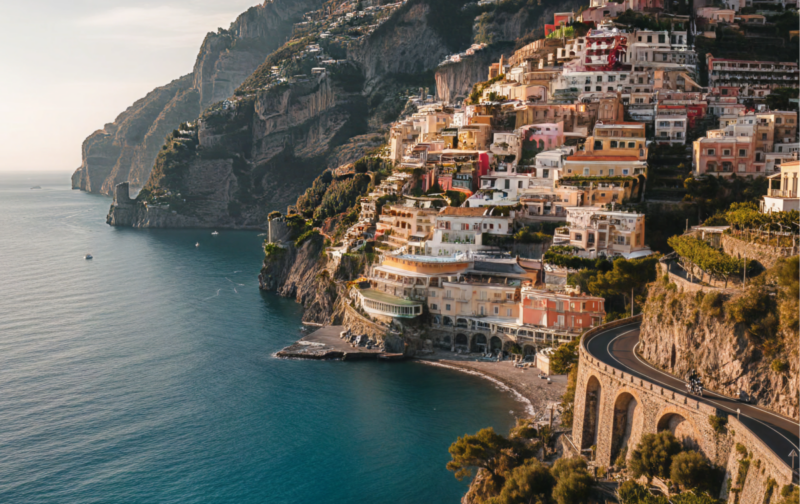
3. Amalfi Coast — SS163, Campania
Distance: 50 km (Vietri sul Mare to Positano)
Best for: Coastal scenery, iconic Mediterranean riding, photography
Best time: April to May, September to October
The Route:
The SS163 Amalfitana is the road that appears on every Italian tourism poster, and for good reason. It clings to the cliffs of the Sorrentine Peninsula between Vietri sul Mare and Positano, carved into the rock face above the Tyrrhenian Sea. UNESCO lists the entire coast as a World Heritage Site. The road passes through Amalfi, Ravello (via a detour up SS373), and a string of villages where pastel buildings stack vertically above tiny harbours. The corners are tight, the views are relentless, and the drop to the sea is real. This is not a fast road. It is a road that demands your attention and rewards your patience.
Do not ride the Amalfi Coast in July or August. The road is choked with tour buses, rental cars, and scooters. Buses take the full width of the road on blind corners, and there is nowhere to go. Spring and autumn are the windows: warm enough for the views, quiet enough for the ride. Start at dawn. By 10 AM even in shoulder season the traffic builds. Ride east to west (Vietri to Positano) for the sea on your left and the best sightlines around right-hand bends. Fuel up before you start: there are stations in Vietri and Amalfi, but they are small and the queues can be long. The road has a one-way system in places during peak hours. Watch for scooters overtaking on blind corners. The detour up to Ravello is worth the extra 15 minutes for the views from the Duomo.
Scenic tip:
Between Amalfi and Positano, there is an unmarked pullover on the seaward side of the road approximately 1 km west of the Grotta dello Smeraldo car park. It fits two bikes. From here, looking west, you can see Positano stacked on the cliff with Li Galli islands beyond. Early morning, before the haze builds, this is the view. Approximate coordinates: 40.6280, 14.5990.
Technicality: Moderate. Narrow road, tight blind corners, steep drops without guardrails in places, heavy bus traffic. The technical difficulty is not the road surface but the other users.
Ride this route:
Start (Vietri sul Mare): 40.6674, 14.7260
Amalfi: 40.6340, 14.6026
End (Positano): 40.6281, 14.4849
Or get the whole route free here, with Scenic: https://scenicapp.space/route/KMoOGVRD
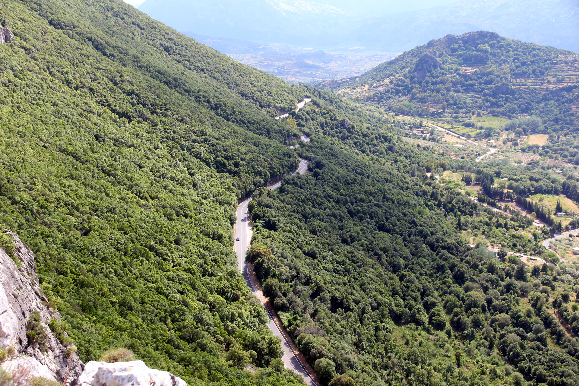
4. Passo Gavia — SS300, Lombardy
Distance: 43 km (Ponte di Legno to Bormio)
Altitude: 2,618 m
Hairpins: Approximately 40 (south side)
Best for: Serious mountain riding, solitude, Stelvio extension
Best time: June to September
The Route:
Passo Gavia is the road that the Stelvio wishes it still was: raw, quiet, and genuinely intimidating. At 2,618 m, it is the second-highest paved pass in Italy. The south side from Ponte di Legno climbs 17 km at an average gradient of 8%, with pitches up to 16%. The hairpins are insanely tight. Sections of the road are barely wide enough for one vehicle, and guardrails are optional. The summit sits at the edge of permanent snowfields, and the views into the Valfurva are immense. The north descent into Bormio is more forgiving. The Gavia is a regular stage of the Giro d’Italia, and in 1988 a stage over the pass in a snowstorm became one of the most legendary days in cycling history. On a motorcycle, it delivers the same intensity with better shelter from the elements.
Ride south to north (Ponte di Legno to Bormio) to tackle the harder climb first and descend into Bormio, where you can refuel and connect directly to the Stelvio Pass for a two-pass day. The Gavia plus Stelvio combination is one of the great day rides in the Alps: approximately 90 km of continuous mountain road. The south side of the Gavia has sections of rough surface and occasional potholes near the edges. Check road condition reports before riding. The pass is snow-closed from October to June. There are no services between Ponte di Legno and Bormio: fuel up at either end. A small coffee bar operates at the summit during peak season, but do not rely on it.
Scenic tip:
Use Scenic’s offline maps for the Gavia. Cell coverage drops to zero between Ponte di Legno and Bormio, and the road has several unsigned junctions where a wrong turn puts you on a gravel track into a ski area. Download the Lombardy region before you start.
Technicality: Expert. Very steep gradients (up to 16%), extremely tight hairpins, narrow road, minimal guardrails, high altitude, no services. Not for inexperienced riders.
Max gradient: 16%
Ride this route:
Start (Ponte di Legno): 46.2579, 10.5095
End (Bormio): 46.4683, 10.3714
Summit (Passo Gavia): 46.3447, 10.4917
Or get the whole route free here, with Scenic: https://scenicapp.space/route/ocfcEwEq
5. Strada della Forra — SP38, Lake Garda
Distance: 16 km (Porto di Tremosine to Pieve); 40 km for the full Lake Garda loop
Best for: Short, intense experience riding, James Bond fans, Lake Garda day trips
Best time: April to June, September to October (weekdays only)
The Route:
The Strada della Forra is 16 km of road carved into the gorge of the Brasa River on the western shore of Lake Garda. Winston Churchill called it “the eighth wonder of the world.” The opening chase scene of James Bond’s Quantum of Solace was filmed here. The road climbs from 65 m at Porto di Tremosine to 420 m at Pieve through a succession of tight hairpins, dark tunnels overgrown with climbing plants, rock overhangs, and sudden views of the lake below. It was built in 1913 to connect the isolated communities of Tremosine to the lakeside. It is short, it is not fast, and it is not to be missed.
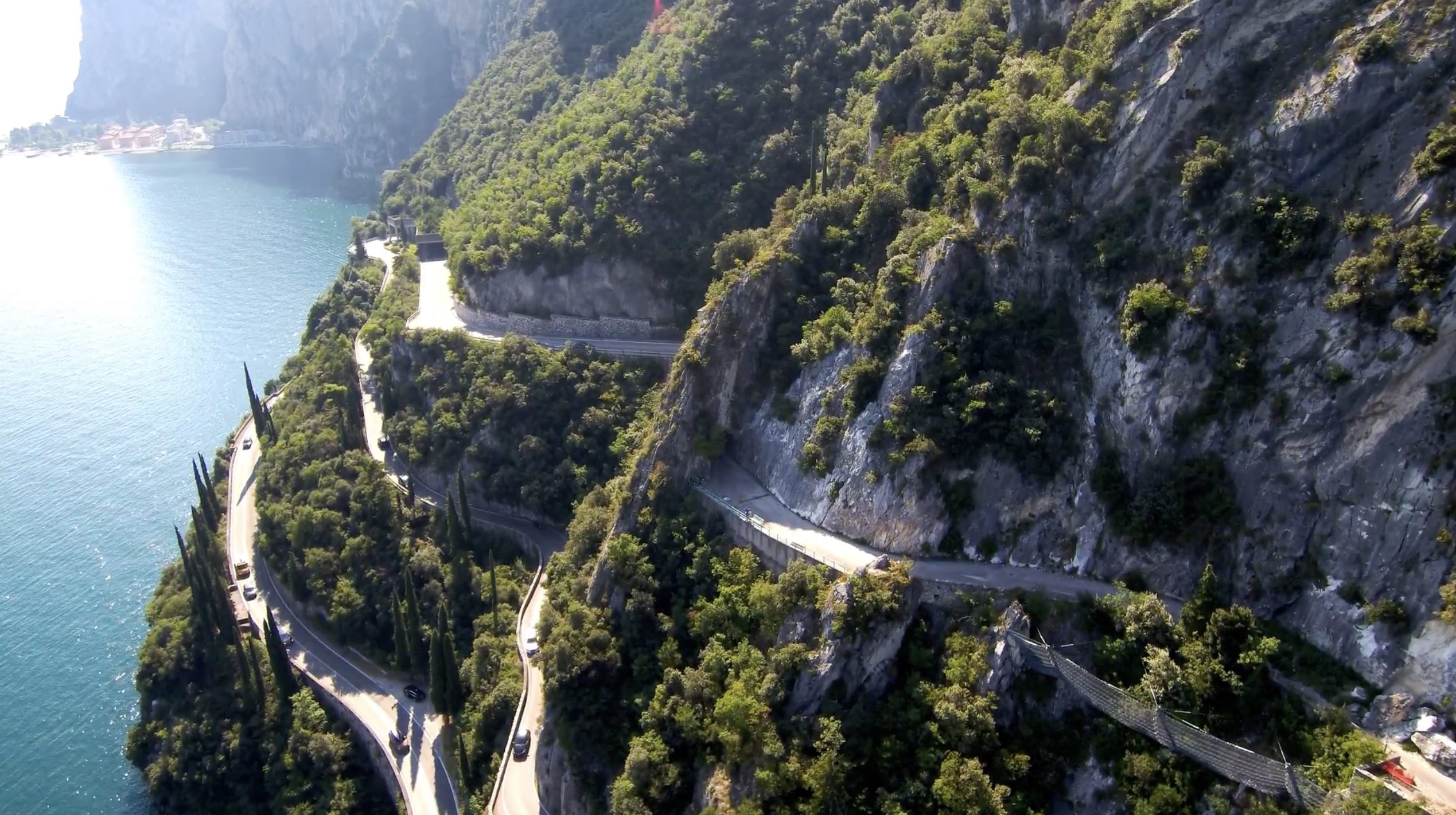
The Forra reopened in August 2025 after a major rockfall closure. A permanent one-way system now operates uphill from the Gardesana road junction to Pizzeria la Forra. From there to Pieve it remains two-way. Ride it uphill for the best experience: the lake views open up behind you as you climb. Do not ride it on weekends or in August: the road is very narrow, buses use it, and traffic jams in a tunnel are no fun on a motorcycle. Combine the Forra with the SP115 from Pieve to Limone sul Garda for a 40 km lakeside loop. The Terrazza del Brivido in Pieve is a glass-floored viewing platform suspended 350 m above the lake, accessible free via the Hotel Paradiso bar. Fuel is available in Limone sul Garda and along the Gardesana road.
Scenic tip:
The Terrazza del Brivido (Thrill Terrace) in Pieve di Tremosine is a cantilevered platform 350 m above Lake Garda. It is free to access through the Hotel Paradiso bar. Have a coffee, look down, and appreciate the engineering that put a road through the cliff you are standing on. Coordinates: 45.7895, 10.7585.
Technicality: Moderate. Narrow road, tight tunnels with low headroom, variable surface. Not technically extreme but requires full attention and modest speeds.
Ride this route:
Start (Porto di Tremosine, Gardesana junction): 45.7686, 10.7621
Pieve di Tremosine: 45.7895, 10.7585
End (Vesio): 45.7920, 10.7450
Or get the whole route free here, with Scenic: https://scenicapp.space/route/THkVJGEV
6. Via Chiantigiana — SR222, Tuscany
Distance: 82 km (Florence to Siena)
Best for: Touring pace, wine country, rolling Tuscan hills, all experience levels
Best time: April to June, September to November
The Route:
The SR222, known as the Via Chiantigiana, is the road through the heart of Chianti. It connects Florence and Siena through 82 km of vineyards, olive groves, cypress-lined ridges, and medieval villages. The road surface is smooth, the curves are flowing rather than technical, and the pace is set by the landscape rather than the gradient. This is not a road you attack. It is a road you cruise, stopping in Greve in Chianti for a coffee, in Castellina for a view, and in Radda for a plate of pici with wild boar ragu. The Chianti region is the Italy that people imagine before they arrive, and the SR222 delivers it without pretension.

Ride south from Florence to Siena: the approach to Siena through the final Chianti hills is a fitting end to the day. The road is well-signed and carries moderate traffic, heavier near Florence. It is not a fast road, and the speed limits through villages are enforced. For a longer day, combine the Chiantigiana with the Crete Senesi area south of Siena, where the terrain changes to bare clay hills and isolated farmsteads: the road from Asciano to Buonconvento is a masterclass in Tuscan scenery. Wine tasting is everywhere. Leave the helmet at the bike and walk into any cantina with a sign. Castello Vicchiomaggio, between Greve and Panzano, has a wine shop with views worth the stop.
Scenic tip:
Between Panzano and Castellina in Chianti, there is a stretch of the SR222 that crests a ridge with vineyards falling away on both sides. In the late afternoon, the light turns golden and the rows of vines cast long shadows down the hillside. It is not a named viewpoint. It does not need to be.
Technicality: Easy. Smooth, flowing road with gentle curves. Suitable for all riders, all bikes, and riders who have been drinking espresso all morning.
Ride this route:
Start (Florence, Porta Romana): 43.7590, 11.2490
Greve in Chianti: 43.5833, 11.3190
End (Siena): 43.3188, 11.3308
Or get the whole route free here, with Scenic: https://scenicapp.space/route/NNuXdjKl
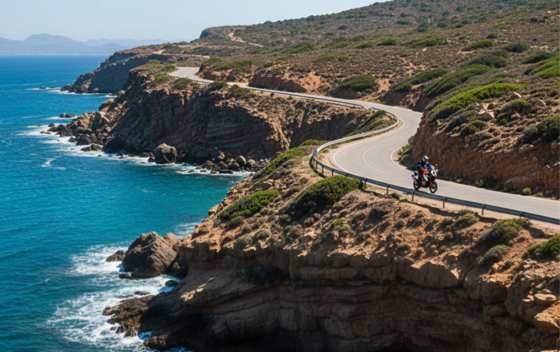
7. SS125 Orientale Sarda — Dorgali to Arbatax, Sardinia
Distance: 60 km
Best for: Endless curves, perfect tarmac, wild Mediterranean scenery
Best time: April to June, September to November
The Route:
The SS125 between Dorgali and Arbatax is one of the finest motorcycle roads in Europe, and most European riders have never heard of it. The road follows the eastern flank of the Supramonte mountains above the Gulf of Orosei, threading through 60 km of continuous curves on flawless asphalt. The rhythm is addictive: short straights into flowing bends, right-left-right, never repeating, never boring. The landscape is wild Sardinia: chalky limestone peaks, dense maquis scrub, and occasional glimpses of the sea far below. Traffic is almost nonexistent outside summer. The full SS125 runs from Cagliari to Olbia (the entire eastern coast), but this section is the concentrated highlight.
Ride north to south (Dorgali to Arbatax) for the best light on the mountain faces in the morning. Fuel up in Dorgali before starting: there is nothing between Dorgali and Baunei, a stretch of nearly 40 km. The road passes through Baunei, where a short detour east leads down to Cala Gonone on the coast, emerging from a tunnel with the entire Gulf of Orosei spread below. At Passo Ghenna Silana, near the top, there is a small coffee bar where riders gather, drink espresso, and buy commemorative t-shirts. Getting to Sardinia requires a ferry: Civitavecchia to Olbia (6–8 hours) or Genoa to Olbia (10–12 hours). Book motorcycle spaces early in summer.
Scenic tip:
At the exit of the tunnel approaching Cala Gonone (a short detour east from the SS125 at Dorgali), the Gulf of Orosei opens up below you in a single panoramic hit. It is one of the great reveal moments in European motorcycling. Park at the tunnel exit and take it in before descending to the harbour for lunch.
Technicality: Moderate. Continuous curves requiring sustained concentration, good surface, minimal traffic. The challenge is maintaining focus over 60 km of non-stop corners.
Ride this route:
Start (Dorgali): 40.2880, 9.5920
Baunei: 40.0340, 9.6670
End (Arbatax/Tortolì): 39.9380, 9.6880
Or get the whole route free here, with Scenic: https://scenicapp.space/route/XhzQijNk
8. Alghero to Bosa — SP105/SP206, Sardinia
Distance: 45 km
Best for: Coastal riding, Mediterranean views, a short ride worth the journey
Best time: April to November
The Route:
The coastal road from Alghero to Bosa on Sardinia’s northwest coast is consistently rated as one of the most beautiful coastal roads in the Mediterranean. The SP105 (becoming SP106, which is SP49 on Google Maps, at the provincial border) runs 45 km along cliff tops above the sea, with the water on your right if riding south and nothing between you and the horizon. The road alternates between flowing straights and technical curves cut into the rock. There is almost no development along the route: no towns, no petrol stations, no traffic lights. Just road, cliff, and sea. Bosa, at the far end, is one of the most colourful small towns in Italy, with pastel houses stacked along the Temo River.
This is a short ride: about 1 hour without stops. To build a full day, combine it with the island’s interior. From Bosa, ride east on the SS129 through the Barbagia region toward Nuoro, then loop back north to Alghero via the SS131 and SS291. This gives you coast, mountain, and plains in a single day of approximately 250 km. Alternatively, ride the Alghero–Bosa road in both directions: it is genuinely different each way, and the second run lets you notice what you missed the first time. Fuel up in Alghero before starting. There is a fuel stop in Bosa but nothing in between. Sardinian roads can have gravel washed onto the surface after rain, particularly on cliff sections.
Scenic tip:
Scenic’s Round Trip feature is useful for Sardinia exploration. Set your start point in Alghero, your desired distance (200–250 km), and let Scenic generate a loop that incorporates the coastal road to Bosa and the mountain interior. It solves the problem of planning return routes on an island where the obvious option is always the motorway.
Technicality: Easy to moderate. Well-surfaced, flowing coastal road with some tighter cliff sections. Suitable for most riders.
Ride this route:
Start (Alghero): 40.5580, 8.3190
End (Bosa): 40.2985, 8.5006
Or get the whole route free here, with Scenic: https://scenicapp.space/route/GnrSigNk
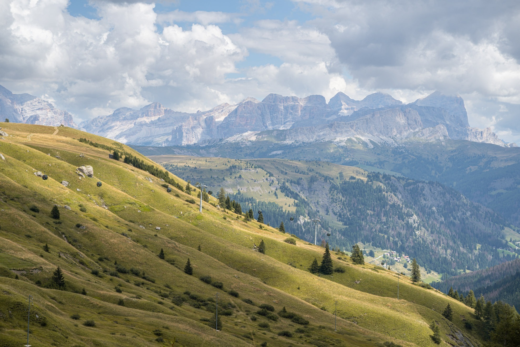
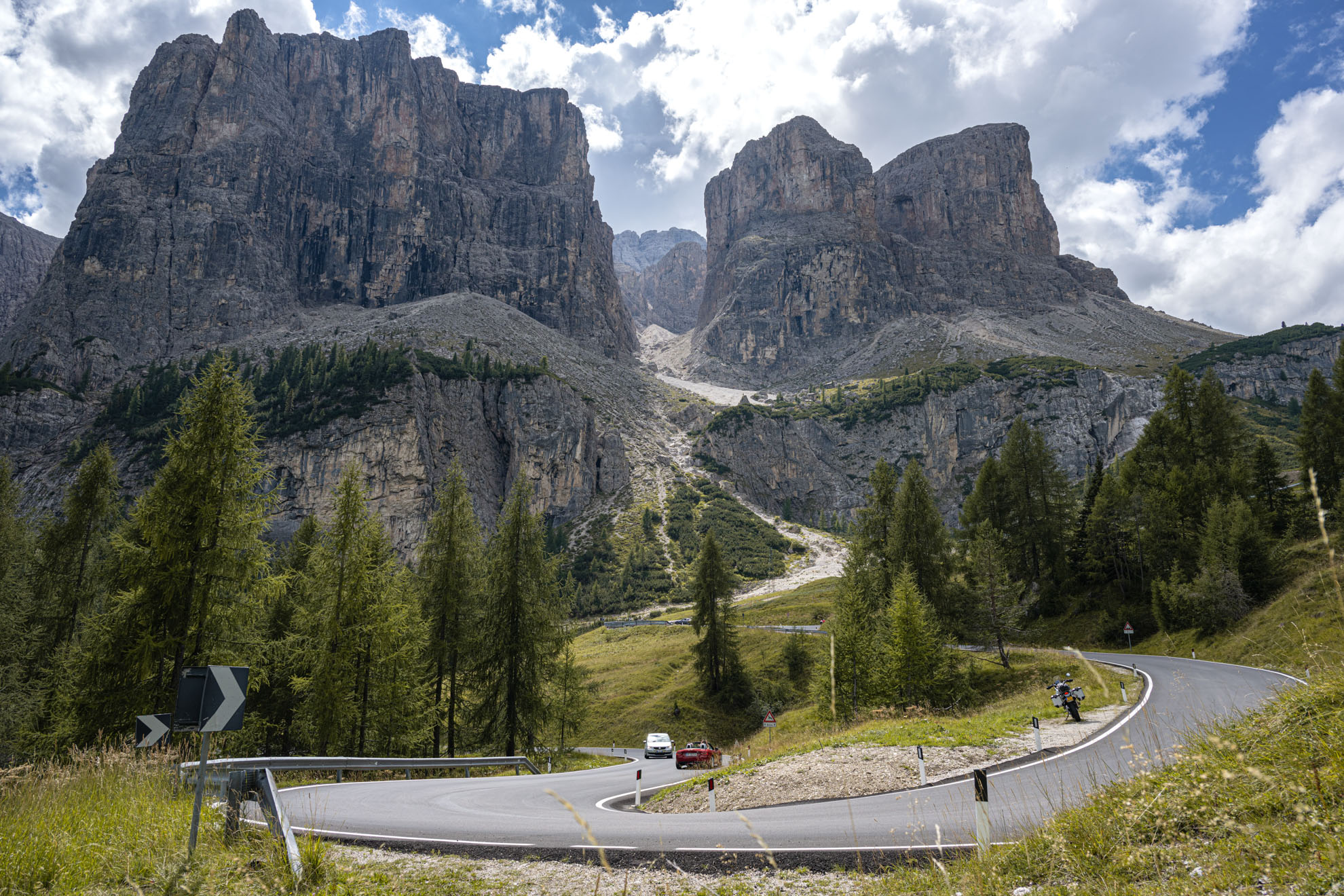
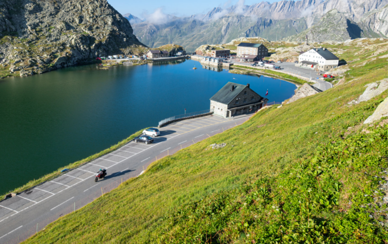
9. Passo Giau — SP638, Dolomites/Veneto
Distance: 28 km (Cortina d’Ampezzo to Selva di Cadore)
Altitude: 2,236 m
Best for: Technical riding, Dolomite photography, quieter alternative to Sella Ronda
Best time: June to September
The Route:
Passo Giau is the Dolomite pass that separates tourists from riders. The north side, descending toward Cortina d’Ampezzo, features a series of tight, technical hairpins that demand precision and reward clean lines. The road is narrower than the Sella Ronda passes, the surface is good but not forgiving, and the views of the Cinque Torri rock formation and the Nuvolau peak are among the finest in the range. The south side from Selva di Cadore climbs more gradually but still delivers. This is not a warm-up road. It is a road for riders who have already dialled in their Alpine technique on the Sella Ronda and want something that asks more questions. It is also less crowded than the main Dolomite circuit.
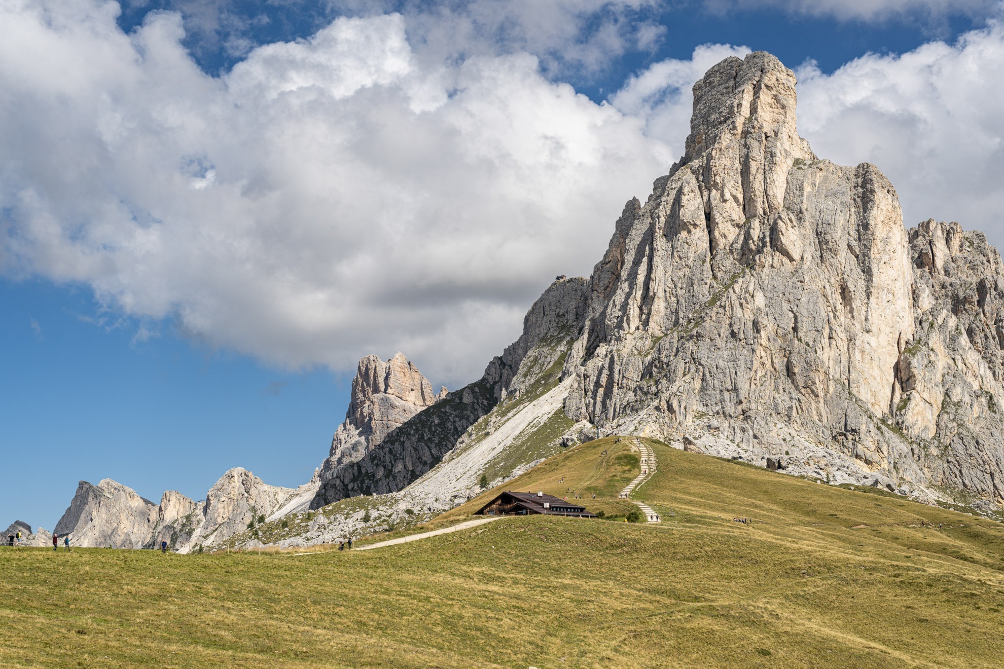
Image credit – our very own @LNR <3
This is a short route: 28 km takes well under an hour. Combine it with Passo Falzarego (2,105 m) to the north and Passo Staulanza to the south for a full day of Dolomite riding. From Cortina, you can build a loop via Passo Falzarego, Passo Valparola, down to Corvara, then back through the Sella Ronda and returning via Passo Giau: approximately 120 km with six passes. Fuel is available in Cortina and Selva di Cadore. The road is snow-closed from October to June. In early summer, check reports for residual ice patches on the north-facing hairpins.
Scenic tip:
At the summit of Passo Giau, the Rifugio Passo Giau serves coffee with a view of the Nuvolau massif that alone justifies the ride. From the rifugio terrace, looking north, the entire amphitheatre of Dolomite peaks is laid out in front of you. Go before 9 AM for the best light and empty tables.
Technicality: Advanced. Narrow road, tight technical hairpins on the north side, altitude. Requires solid cornering technique. Not for beginners.
Ride this route:
Start (Cortina d’Ampezzo): 46.5369, 12.1361
Summit (Passo Giau): 46.4832, 12.0525
End (Selva di Cadore): 46.4525, 12.0272
Or get the whole route free here, with Scenic: https://scenicapp.space/route/nbMZOiqA
10. Passo del Gran San Bernardo — SS27, Valle d’Aosta
Distance: 34 km (Aosta to Swiss border)
Altitude: 2,469 m
Key passes: Gran San Bernardo (2,469 m)
Best for: Alpine touring, Italy–Switzerland crossing, history
Best time: June to September
The Route:
The Great St Bernard Pass is one of the oldest crossings in the Alps, used since the Bronze Age and made famous by Napoleon’s crossing in 1800. The SS27 climbs from Aosta through the Aosta Valley to the summit at 2,469 m, where a hospice run by Augustinian monks has sheltered travellers since the 11th century (and where the St Bernard dog breed originates). The road is wide by Alpine standards, well-maintained, and the hairpins are open enough to flow through at a proper pace. The scenery is classic high Alps: green valley floor rising to rock and permanent snowfields. At the summit, the hospice and a small lake sit at the border with Switzerland.
Ride from Aosta north to the summit. The return to Aosta by the same road is satisfying in itself, but to extend the day, continue into Switzerland (road conditions and border formalities are minimal) and loop back via the Simplon or Lötschberg tunnels. The pass is a natural pairing with the Mont Blanc tunnel (to Chamonix) for riders doing a multi-day Alpine tour. Fuel is available in Aosta and at the Saint-Rhémy-en-Bosses village partway up. The summit hospice serves food and is worth a stop for the history alone. The road is snow-closed from October to June.
Scenic tip:
The Augustinian hospice at the summit has operated continuously for over 1,000 years. You can visit the kennels where St Bernard dogs were bred for mountain rescue (the breeding programme relocated in 2005, but the hospice maintains a small exhibition). It is the oldest travellers’ refuge in the Alps. Have lunch at the hospice restaurant and absorb a millennium of history.
Technicality: Moderate. Well-surfaced, wide hairpins, steady gradients. Good for competent riders who want Alpine scenery without Stelvio-level intensity.
Ride this route:
Start (Aosta): 45.7370, 7.3150
Summit (Gran San Bernardo): 45.8688, 7.1706
Or get the whole route free here, with Scenic: https://scenicapp.space/route/zCBHJWtH
Planning Your Ride
The Italian riding season runs from April to October for most of the country, with significant regional variation. Alpine passes (Stelvio, Gavia, Giau, Gran San Bernardo) are snow-closed from October to June: check exact opening dates annually, as they depend on snowfall. Sardinia and the south are rideable year-round, though summer heat (July–August) makes midday riding uncomfortable. The Amalfi Coast and Lake Garda are unusable on summer weekends due to traffic. Spring (April–June) and autumn (September–October) are the optimal windows for the entire country.
Italian motorcycle law requires headlights on at all times, a high-visibility vest to be carried on the bike (for use if you stop on the roadside), and a helmet with CE certification. Dipped beam must be used during the day on motorways and dual carriageways. ZTL (Zona Traffico Limitato) zones in city centres are enforced by cameras and apply to motorcycles: check before entering any historic centre. Motorway tolls are charged by distance; motorcycles pay a reduced rate. The Telepass electronic toll device works on motorcycles and avoids queuing at booths. Speed cameras are common on the approach to towns and in tunnels.
Scenic’s offline maps are essential for Alpine passes and Sardinia, where mobile coverage is unreliable. Download region maps before leaving your accommodation each morning.
Italy has more good roads than any single trip can cover. Pick your region, plan your loop, and go.
Where to base yourself
Bolzano is the gateway to the Dolomites: the Sella Ronda, Passo Giau, and the approach to the Stelvio are all within 90 minutes. It has excellent accommodation, fuel infrastructure, and a bilingual Italian–German culture that makes logistics easy. Bormio serves the Stelvio and Gavia passes directly, and is the natural base for a two-pass day. Sirmione or Riva del Garda cover the Lake Garda area including the Strada della Forra. Alghero is the best base for Sardinia’s northwest coast road to Bosa and a launching point for the SS125 via the island’s interior.
Frequently asked questions
What is the best time of year to ride a motorcycle in Italy? Late May to mid-June and September to early October. The Alpine passes are open, the coastal roads are quiet, and temperatures are comfortable at all altitudes. July and August bring extreme heat in the south, heavy traffic on tourist routes, and crowded passes in the Dolomites.
When does the Stelvio Pass open and close? The Stelvio typically opens in late May or early June and closes in late October, depending on snowfall. Exact dates are announced annually by the Province of Bolzano. The Gavia and Giau follow a similar schedule. Always check current status before riding.
Do you need a high-vis vest to ride a motorcycle in Italy? You must carry one on the bike. You are required to wear it if you stop on the roadside or in an emergency outside built-up areas. It does not need to be worn while riding.
How do motorway tolls work for motorcycles in Italy? Motorcycles pay a reduced toll rate (Category A). You can pay by cash, card, or Telepass at toll booths. Telepass is the most convenient option: it attaches to the bike and processes tolls automatically. You can rent a Telepass device for short trips.
Can you take a motorcycle to Sardinia? Yes, by ferry. The main routes are Civitavecchia to Olbia (6–8 hours), Genoa to Olbia (10–12 hours), and Livorno to Olbia (8 hours). Tirrenia, Moby, and Grimaldi operate motorcycle-friendly ferries. Book early in summer: motorcycle spaces sell out.
Is lane splitting legal in Italy? There is no specific law prohibiting or permitting it. Italian riders routinely filter through stationary traffic in cities, and police generally tolerate it at low speed. On open roads and motorways, stay in your lane.
What’s the deal with Scenic? Scenic Premium gives you turn-by-turn navigation designed for motorcyclists, global offline maps, and automatic curvy routing that keeps you on the passes and off the motorways. For an Italian trip, the offline maps alone justify it: Alpine coverage drops to zero on the best roads in this article.
You Made It: Join Us
If you go, tag us and use the hashtag #ridewithscenic for your chance to win a free Scenic t-shirt.
You’ve made it to the end of the article! At Scenic we like to reward people who plan their trips properly. If you’re not already a premium member, use this code to get 15% off your first year of Scenic Premium: Premium15


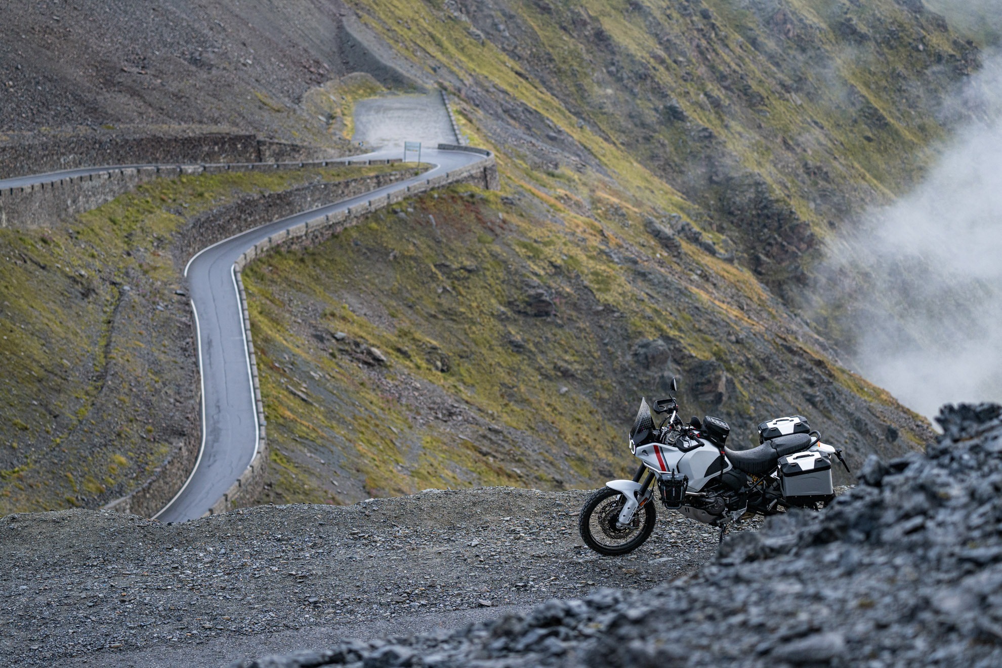
The image under 4 Passio Gavia doesn’t show Passo Gavia. It’s an image of Passio Giau
🤦♂️ thanks for the spot! Must have gotten muddled