England packs more riding variety into a small island than most countries ten times its size. The best motorcycle roads in England range from technical mountain passes with 33% gradients to open moorland sweepers, coastal cliff roads and historic day loops through some of the finest countryside in Europe. This guide covers ten verified routes across ten distinct regions. Whether you are planning motorcycle touring in England for the first time or filling in gaps on a map you have been building for years, these are the routes worth your time.
In this guide:
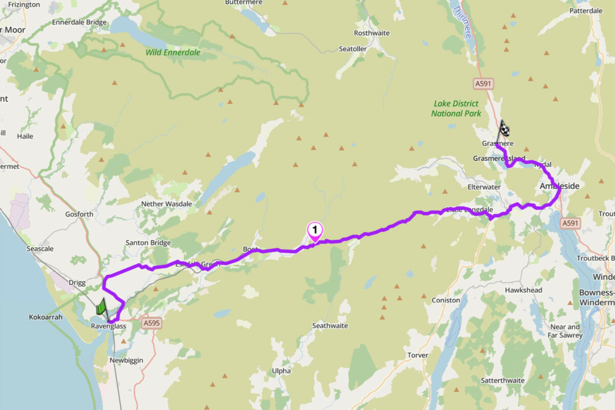
1. Hardknott Pass: Ravenglass to Grasmere, Lake District
Distance: 27 miles (Ravenglass to Grasmere, including Hardknott and Wrynose passes)
Altitude: 1,289 ft (Hardknott summit), 1,360 ft (Wrynose summit)
Max gradient: 33% (1 in 3)
Best for: Technical riding, adventure bikes, bucket list passes
Best time: May to September (closed or hazardous in winter)
The Route
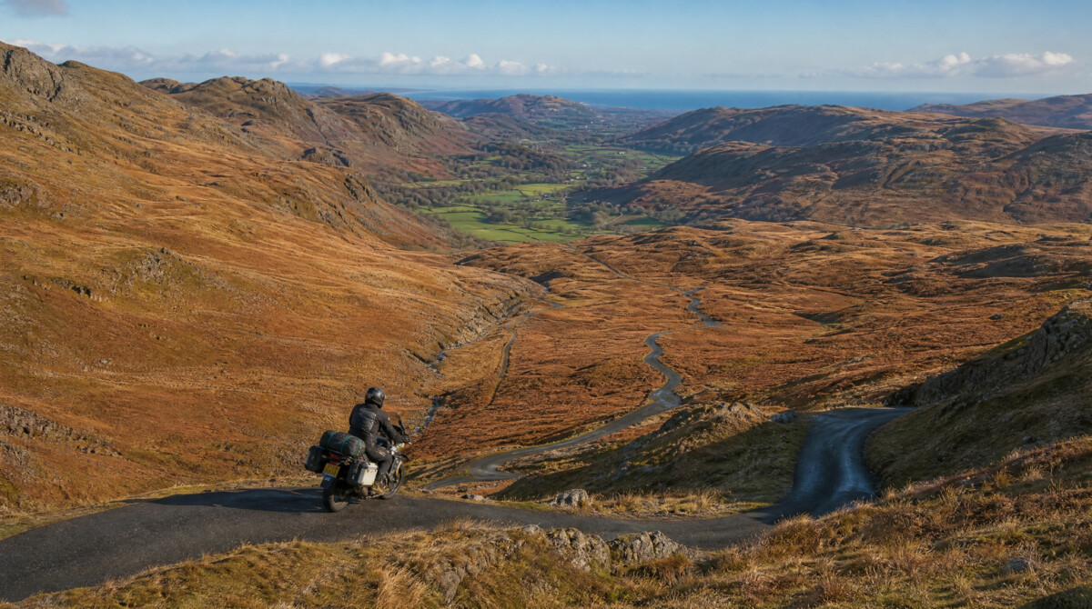
This is the hardest road in England. Hardknott Pass connects Eskdale in the west to Cockley Beck in the east, linking directly to Wrynose Pass and continuing to Little Langdale. The gradient reaches 33% on the final approach from both sides, with 13 hairpin bends on the ascent. The road is single-track for most of its length, with unguarded drops and sections where passing is impossible. At the summit, the remains of Hardknott Roman Fort (Mediobogdum) sit above the road, built around AD 120 to guard this crossing. Standing there, you understand why the Romans went through the trouble.
The route starts at Ravenglass on the A595, passing Muncaster Castle before the road picks up the Eskdale valley at Eskdale Green – an easy warm-up with the fells closing in as you head east. East of Boot the road narrows and the gradient signals what is coming: lower slopes at 11%, then switchbacks at 30%+ that force you into first gear. Pause at the Roman Fort before the descent into Cockley Beck, the climb of Wrynose Pass at 1,360 ft, and the descent to Little Langdale. The A593 east to Ambleside and Grasmere closes the route with easy valley riding. This road is not suitable for inexperienced riders or heavily loaded adventure bikes: the narrow hairpins at 33% demand low-speed technical confidence.
Scenic tip
Stop at the Hardknott summit on a clear day and look west. On the right conditions you can see the Isle of Man from here. Set off early. By mid-morning in summer, tourist traffic builds on the approach roads and passing becomes a slow negotiation. Weekdays in May or September give you the best chance of having the pass to yourself.
Ride this route
Start (Ravenglass, A595): 54.3557, -3.4073
Summit (Hardknott Pass): 54.4031, -3.1885
End (Grasmere, A591): 54.4594, -3.0237
Or get the whole route free here, with Scenic: https://scenicapp.space/route/UfyKYPXE
Hardknott Pass — Ravenglass to Grasmere, Lake District
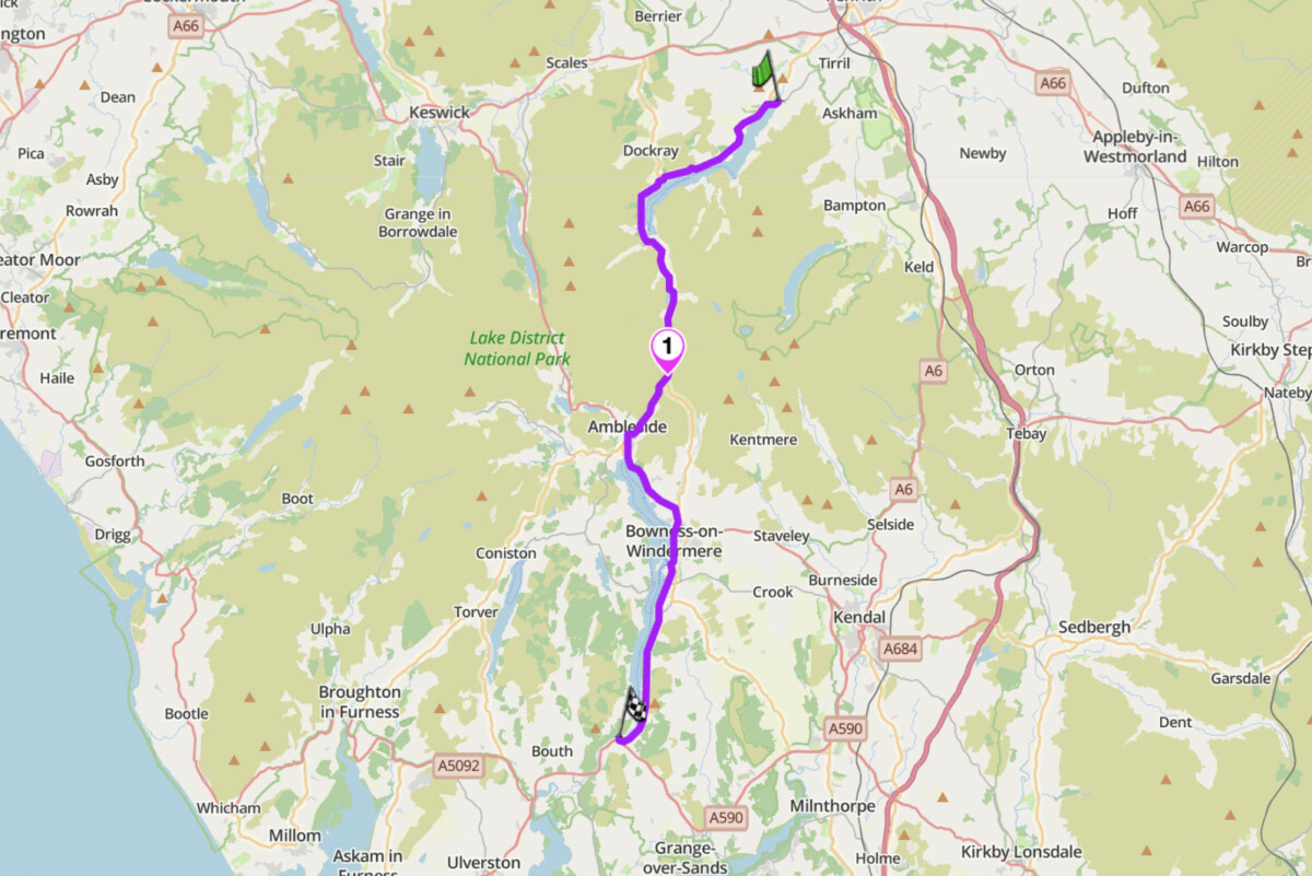
2. Kirkstone Pass: A592, Lake District
Distance: 32 miles (Pooley Bridge to Newby Bridge via Kirkstone Pass)
Altitude: 1,489 ft (highest open road in the Lake District)
Max gradient: 25%
Best for: Fast touring, scenery, all abilities
Best time: April to October
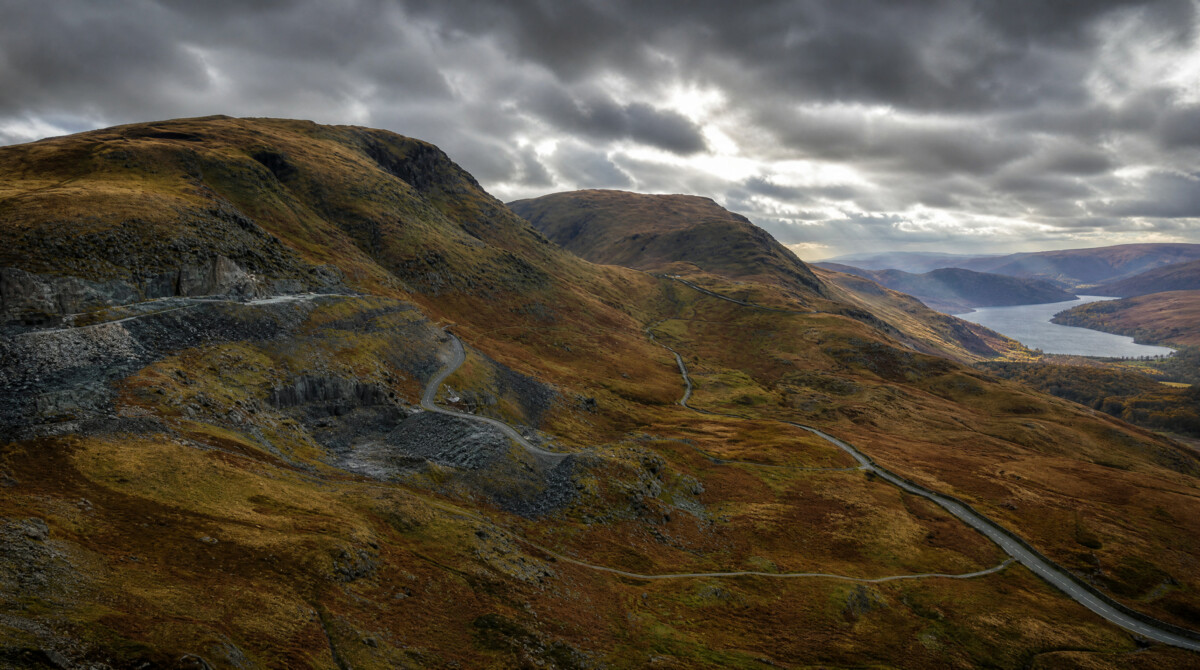
The Route
Kirkstone Pass is the highest motor road in the Lake District and the most accessible of the major passes. The A592 runs from Ullswater in the north to Windermere in the south, climbing to 1,489 ft with a maximum gradient of 25%. At the summit sits the Kirkstone Pass Inn, second highest pub in England, open for over 500 years. Below the northern descent, Brothers Water sits in the valley, flat and still on a calm morning. Ullswater, at the northern end, is regularly rated the most beautiful lake in England.
The route starts at Pooley Bridge at the northern tip of Ullswater, following the A592 south along the lake shore to Patterdale – the approach road is the warm-up, and the light on the water on a clear morning is worth the ride alone. From Patterdale, the road climbs past Brothers Water to the summit at the Kirkstone Inn before the descent through Troutbeck to Windermere. The descent has long, well-sighted corners that reward smooth, flowing lines. From Windermere the route continues south through Bowness to Newby Bridge, an easy lakeside run that closes the route without demanding anything further. Coaches pull over without warning on this road and the surface collects standing water after rain. Keep your pace honest on the descent.
Scenic tip
Download Scenic’s offline maps before leaving Pooley Bridge. Signal disappears around Brothers Water and stays absent to the Patterdale end. The A592 is easy to navigate without signal if you have the route saved, but the junctions around Glenridding can send you wrong without it.
Ride this route
Start (Pooley Bridge, A592): 54.6127, -2.8196
Summit (Kirkstone Pass Inn): 54.4653, -2.9248
End (Newby Bridge, A592): 54.2671, -2.9670
Or get the whole route free here, with Scenic: https://scenicapp.space/route/jOqCnFCr
Kirkstone Pass — A592, Lake District
3. Buttertubs Pass: B6270, Yorkshire Dales
Distance: 25 miles (Muker to Leyburn via Buttertubs Pass and Wensleydale)
Altitude: 1,726 ft (summit)
Max gradient: 20% (northern approach)
Best for: Pass riding, dramatic moorland scenery, Yorkshire Dales day loop
Best time: April to October
The Route
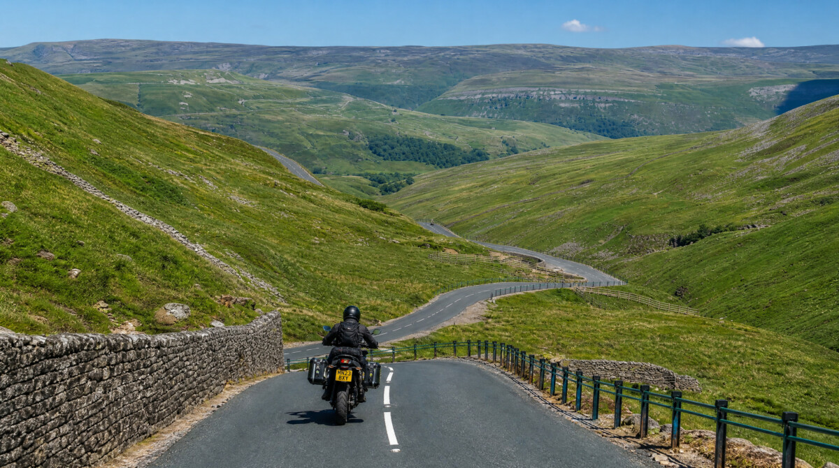
Jeremy Clarkson called Buttertubs Pass “England’s only truly spectacular road.” That is an overstatement, but not by much. The B6270 crosses high moorland between Wensleydale in the south and Swaledale in the north, climbing to 1,726 ft with two Alpine-style switchbacks on the northern approach. The road takes its name from the limestone potholes near the summit: vertical shafts up to 20 metres deep, formed over millennia by water eroding carboniferous rock. Farmers reputedly used them to cool butter on hot market days. The pass featured in Stage 1 of the 2014 Tour de France Grand Depart.
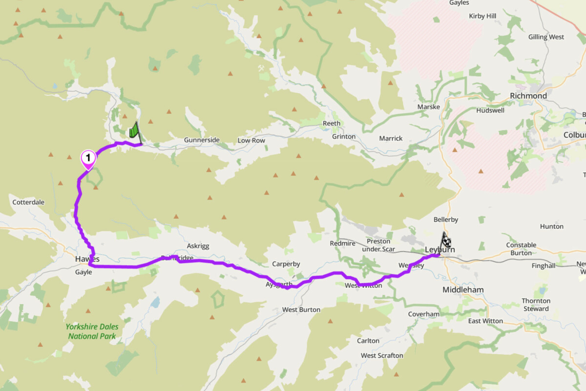
The route starts in Muker, following the B6270 west to Thwaite before the road climbs south toward the pass. The switchbacks arrive at around a mile from Thwaite. Past the summit pull-in, the road drops more gently toward Hawes – fuel, food and the Wensleydale Creamery. The return east along the A684 through Askrigg and Aysgarth to Leyburn is easy, flowing valley riding: wide open, good surface, light traffic. Aysgarth Falls is a natural stop on the way through. The summit is genuinely exposed to crosswind, which is the main hazard here, not the gradient. Approach the northern switchbacks with smooth throttle and be aware that the road is narrow enough to make an oncoming vehicle a problem at speed.
Scenic tip
The pull-in at the summit is small but always used by riders. The potholes sit immediately beside the road on both sides. Look into them on a wet day: water cascades directly into the shafts. Search public routes tagged “Yorkshire Dales” on Scenic and sort by rating. Local riders have mapped several full-day loops that take in Buttertubs, Swaledale and Wharfedale in a single circuit.
Ride this route
Start (Muker, B6270): 54.3763, -2.1404
Summit (Buttertubs Pass): 54.3600, -2.1950
End (Leyburn): 54.3098, -1.8285
Or get the whole route free here, with Scenic: https://scenicapp.space/route/QWhaXODZ
Buttertubs Pass — B6270, Yorkshire Dales
4. Cat and Fiddle: A537 / A54, Peak District / Cheshire
Distance: 30 miles (Alderley Edge to Bakewell via the Cat and Fiddle)
Altitude: 1,690 ft (Cat and Fiddle Inn summit)
Speed limit: 50 mph throughout (average speed cameras in operation)
Best for: Technical corners, exposed moorland riding, Peak District bucket list
Best time: April to October
The Route
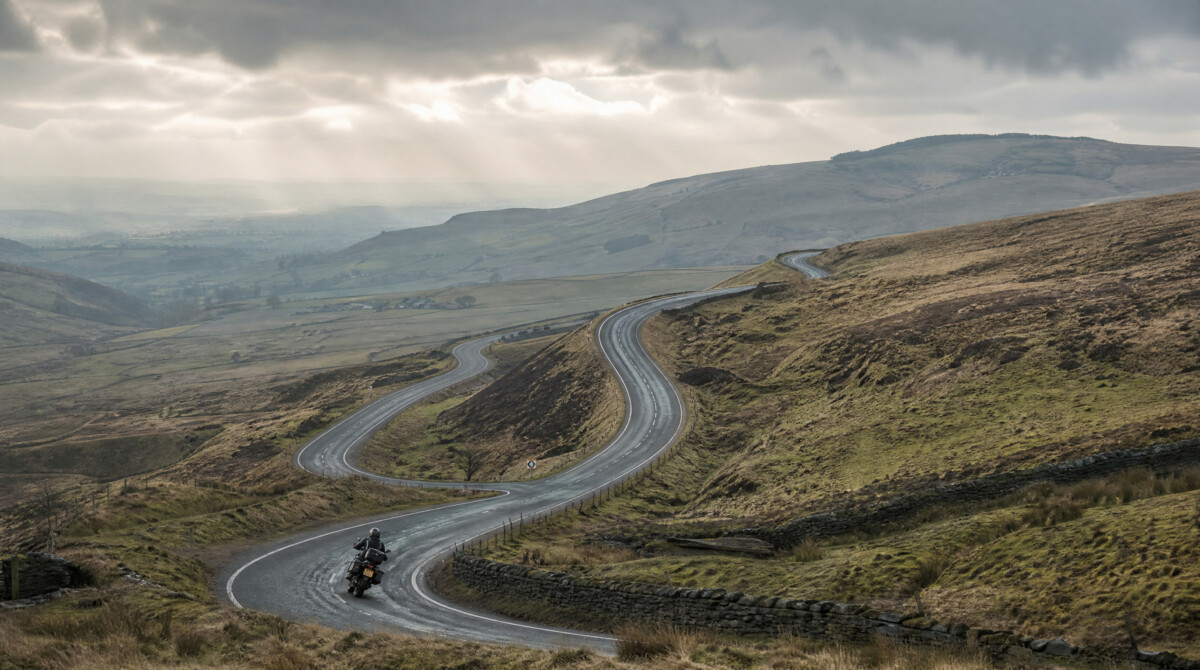
The Cat and Fiddle is England’s most famous motorcycle road, and it has a harder edge than most lists acknowledge. The A537 between Macclesfield and the Cat and Fiddle Inn at 1,690 ft, combined with the A54 to Buxton, is 12 miles of exposed moorland road with a concentrated sequence of technical corners, adverse cambers and surface changes. A blanket 50 mph limit is enforced by rear-facing average speed cameras installed along the Macclesfield-to-summit section, specifically designed to catch motorcycles. The Cat and Fiddle Inn at the summit closed in 2015 and reopened in 2020 as a distillery and bar. The view west toward Manchester and the Cheshire Plain on a clear day is worth the ride alone.
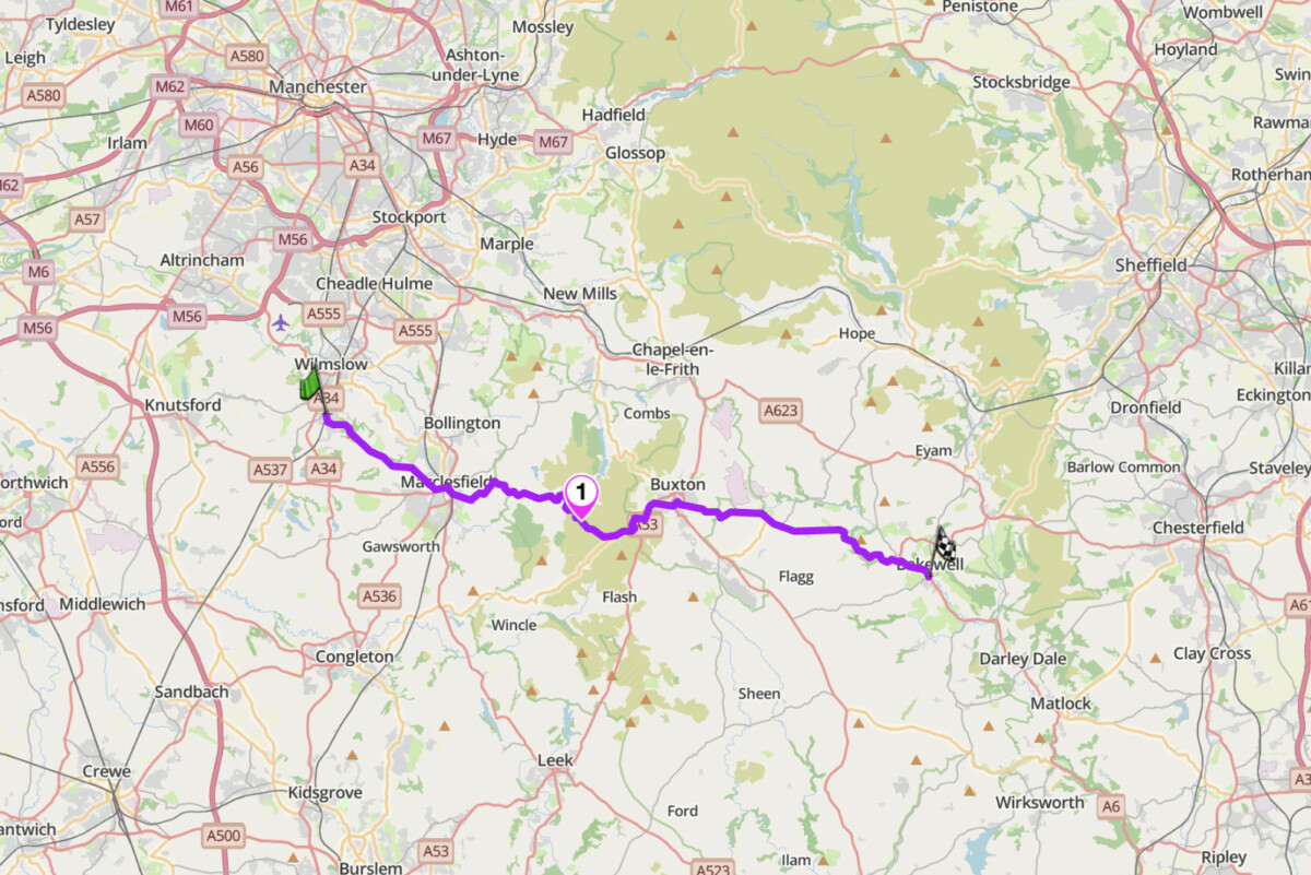
The route starts in Alderley Edge, following the A538 and A523 east to Macclesfield before picking up the A537 onto open moorland. The corners come early and the road demands full attention throughout. The summit section flattens briefly before the A54 junction and the final descent to Buxton. From Buxton the A6 south to Bakewell is an easy, pleasant closer through the limestone Peak District. The road is heavily patrolled on weekends and summer evenings. Weekday mornings in spring or autumn give the cleanest experience.
Extended route, Snake Pass: For a full Peak District day, add the Snake Pass as a second leg. From Bakewell, take the A6 north through Baslow and Hathersage to the A57 junction, then west over the Snake Pass at 1,679 ft to Ladybower Reservoir and on to Glossop. Tighter and more technical than the Cat and Fiddle, with a different mood entirely. Around 60 miles in total. Note that the Snake Pass closes periodically in winter due to snow and landslides. Check road status before riding between November and April.
Scenic tip
The average speed cameras on the Cat and Fiddle are rear-facing and calibrated specifically for motorcycles. Scenic’s navigation gives you accurate speed feedback in real time. Keep it at or below 50 mph through the camera zones and ride the road on its own merits. The A5004 Long Hill road from Buxton toward Whaley Bridge is worth knowing: same elevation, same moorland exposure, far fewer riders and no enforcement infrastructure.
Ride this route
Start (Alderley Edge, A538): 53.3038, -2.2290
Summit (Cat and Fiddle Inn): 53.2447, -1.9995
End (Bakewell, A6): 53.2148, -1.6741
Or get the whole route free here, with Scenic: https://scenicapp.space/route/vPdguMqZ
Cat and Fiddle — A537 / A54, Peak District / Cheshire
5. Military Road: B6318, Northumberland
Distance: 28 miles (Heddon-on-the-Wall to Greenhead)
Best for: Touring, history, Northumberland landscape, decompression riding
Best time: April to October
The Route
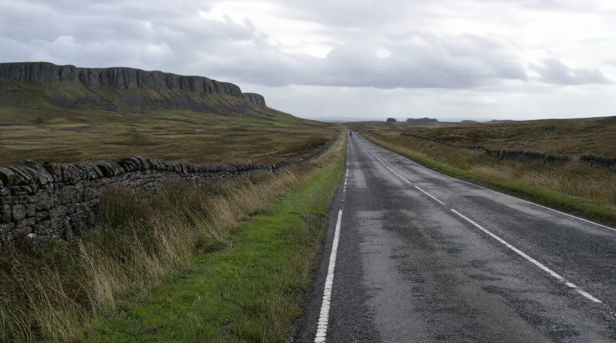
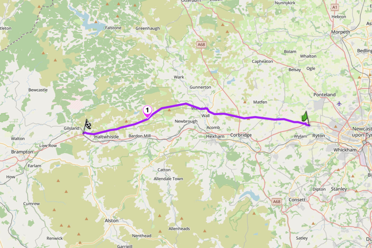
The B6318 runs alongside Hadrian’s Wall from Heddon-on-the-Wall east of Newcastle to Greenhead near the Cumbrian border, covering 28 miles of the most historically significant ground in England. Parts of the road are built directly on the Wall’s foundations. The Romans built Hadrian’s Wall in AD 122 as the northern frontier of the empire. The B6318 follows it because construction of this military road began in 1751, using the Wall’s stone for hardcore: an expedient that historians still argue about. The road is largely straight, resembling a Roman road in design, but crosses a landscape of sudden dips and ridges formed by the Whin Sill escarpment. The blind dips are the hazard. Local traffic knows them and uses the road quickly. Treat each crest as a junction until you know it.
West to east, Greenhead to Heddon-on-the-Wall, keeps the Whin Sill escarpment on your left with views north into Northumberland National Park. From Greenhead the B6318 runs east past Walltown Quarry, Housesteads Roman Fort and Chesters Bridge before descending toward the Tyne valley. Housesteads is one of the best-preserved Roman forts in Britain. The walk from the road takes 20 minutes. Steel Rigg car park gives direct access to the best surviving stretch of the Wall itself. A full day from Newcastle: west on the A69 to Greenhead, east back on the B6318 to Heddon, then north through the national park on the minor roads toward Kielder or Rothbury for a second half in a completely different landscape.
Scenic tip
Download Scenic’s offline maps for Northumberland before you leave. Mobile signal is patchy along the Wall corridor and absent entirely across the national park interior. The deep blind dips between Housesteads and Chesters are the most hazardous section. Cross-traffic from minor junctions can be difficult to see until you are at the junction. Ride the B6318 as if every dip conceals something on the other side.
Ride this route
Start (Greenhead): 54.9820, -2.5344
Key point (Housesteads Roman Fort): 55.0132, -2.3303
End (Heddon-on-the-Wall, B6318 eastern end): 54.9974, -1.7929
Or get the whole route free here, with Scenic: https://scenicapp.space/route/xBKUOxyu
Military Road — B6318, Northumberland
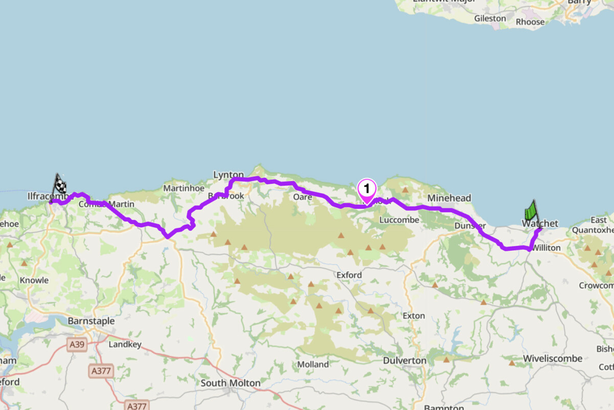
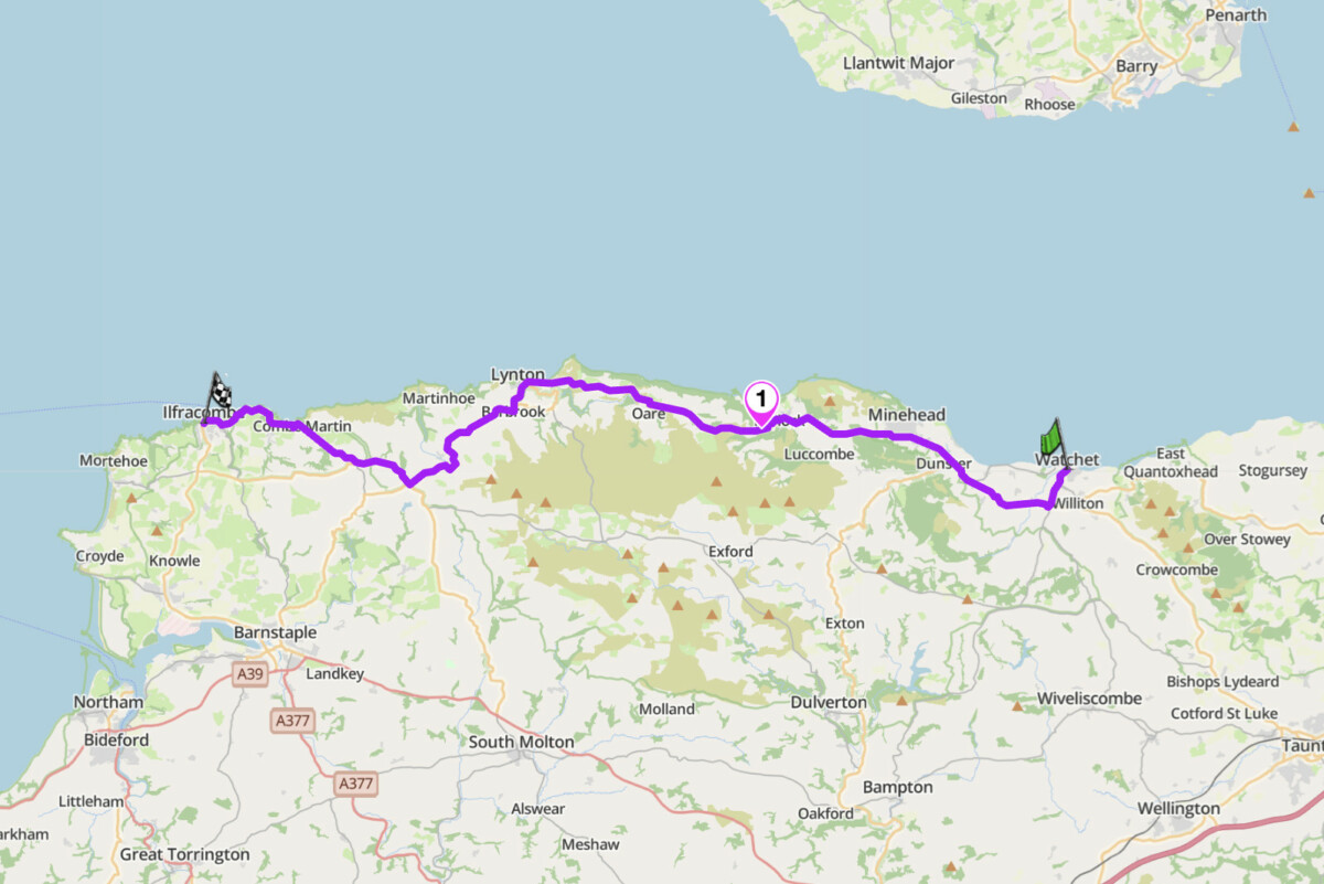
6. A39 Exmoor: Watchet to Ilfracombe, Somerset / Devon
Distance: 44 miles (Watchet to Ilfracombe via Porlock Hill and Lynmouth)
Altitude: 1,141 ft (Porlock Hill summit)
Max gradient: 25% (Porlock Hill, steepest A-road in the UK)
Best for: Coastal moorland touring, dramatic climbing, southwest England adventure
Best time: April to October
The Route
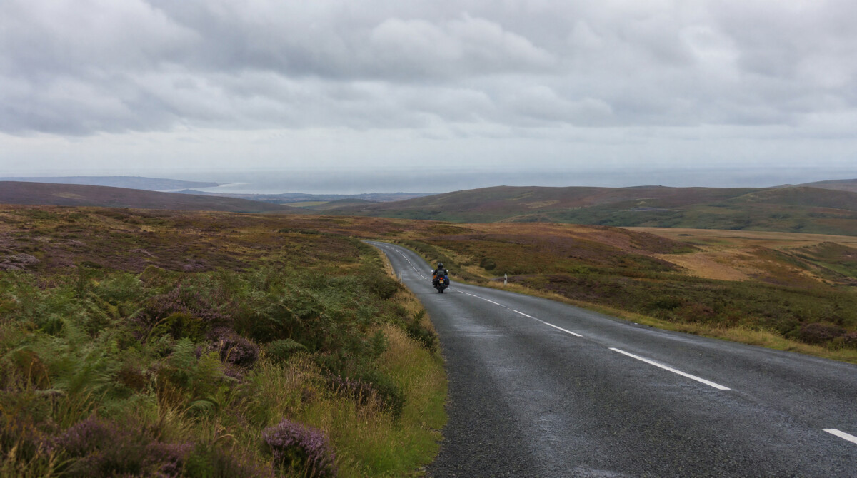
The A39 between Watchet and Lynmouth is the route that defines motorcycle riding in the southwest. It crosses Exmoor National Park along the Bristol Channel coast, climbing twice onto the high moor and descending twice to sea level. The centrepiece is Porlock Hill: the steepest A-road in the UK, climbing steeply onto Exmoor in under 2 miles with a maximum gradient of 25% and two hairpin bends. It is the only A-road in England with escape lanes for runaway vehicles. Warning signs at both ends advise caravans and HGVs to use the adjacent toll road. As a motorcycle, you take the hill.
The route starts in Watchet, following the A39 west through Minehead before Porlock village arrives and the hill begins at its western edge. Climb through the hairpins and break onto open moorland at the top. The road runs across Exmoor with wide views and faster open sections before the descent drops steeply off the moor on a long run into Lynmouth, with a sharp 25% section at the very foot of the hill. From Lynton the A399 continues west through Combe Martin to Ilfracombe, completing the full length of Exmoor’s coast in a single run. Porlock Hill descending is harder than ascending. Use engine braking through both hairpins on the way down. The second hairpin arrives faster than the first. In summer, coaches use this road in both directions.
Scenic tip
Exmoor’s weather changes quickly. The moor sits directly in Atlantic weather systems and mist descends without warning. Download Scenic’s offline maps before departure and check the forecast for the high ground specifically, not just the coast. The moorland section between the two hills, above 1,000 ft, is where the ride opens up. Take your time on the descents at each end.
Ride this route
Start (Watchet, A39): 51.1826, -3.3321
Key point (Porlock Hill summit): 51.2037, -3.6114
End (Ilfracombe): 51.2079, -4.1155
Or get the whole route free here, with Scenic: https://scenicapp.space/route/vogNznZI
A39 Exmoor — Watchet to Ilfracombe, Somerset / Devon
7. B3212 Dartmoor: Bovey Tracey to Tavistock, Devon
Distance: 28 miles (Bovey Tracey to Tavistock via the B3212)
Altitude: 1,476 ft (Princetown)
Speed limit: 40 mph across open moorland sections
Best for: Moorland atmosphere, adventure touring, southwest England decompression
Best time: April to October (fog common year-round on high ground)
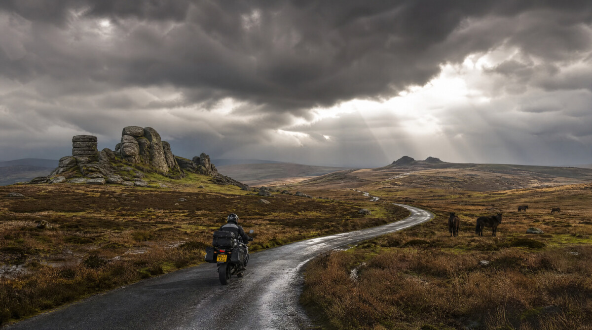
The Route
The B3212 is Dartmoor’s main cross-moorland road, and it is unlike anything else in southern England. From Moretonhampstead the road climbs steadily west, entering the open moor above Headland Warren and running through the heart of the national park past Bennett’s Cross and the Warren House Inn (the highest pub in southern England at 1,425 ft) to Postbridge, Two Bridges and Princetown. The moor here is wild: granite tors emerge from the high ground, Dartmoor ponies graze beside the road, and the sky takes up half the view. The 40 mph limit across the open sections exists because animals wander onto the road without warning. Take it seriously.
The route starts in Bovey Tracey, following the A382 north to Moretonhampstead – the last town before the moor with fuel – before the B3212 climbs west onto the open high ground. East to west is the natural direction: you climb progressively from the enclosed Devon lanes at the eastern edge to the fully open moor. Postbridge, midway, has the ancient clapper bridge over the East Dart River, believed to date from the 13th century. After Princetown the B3357 drops west to Tavistock, an easy finish through enclosed Devon lanes after the exposed crossing. Dartmoor mist is the main hazard: it descends in minutes and reduces visibility severely on the open moor.
Scenic tip
Scenic’s offline maps are essential on Dartmoor: signal is absent across most of the high moor and the junctions around Two Bridges and Dartmeet are easy to misread without navigation. Download the Devon region before departure and keep the screen on for the full length of the B3212. The B3357 south from Two Bridges to Dartmeet gives access to a loop back via Widecombe in the Moor and Hay Tor, adding a further 22 miles of excellent riding.
Ride this route
Start (Bovey Tracey, A382): 50.5932, -3.6784
Key point (Postbridge): 50.5946, -3.9109
End (Tavistock, A386): 50.5496, -4.1426
Or get the whole route free here, with Scenic: https://scenicapp.space/route/NonSliJC
A39 Exmoor — Watchet to Ilfracombe, Somerset / Devon
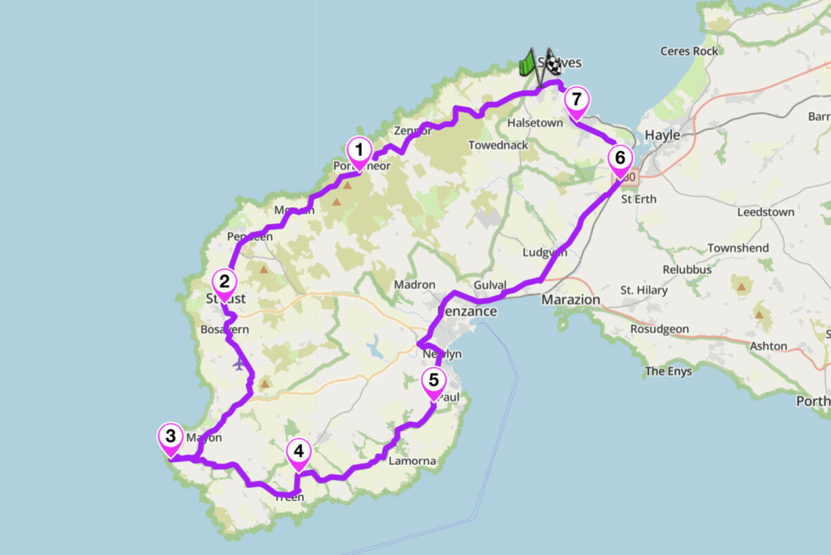
8. Penwith Peninsula Circuit: B3306, Cornwall
Distance: 40 miles (full circuit from St Ives)
Headline road: B3306 St Ives to St Just, 13 miles
Best for: Coastal cliff riding, Atlantic views, technical B-road character
Best time: May to June, September (avoid July to August: tourist coaches on the B3306)
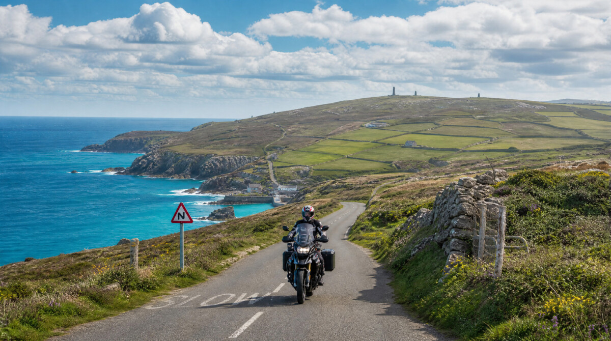
The Route
The B3306 runs along the northern edge of the Penwith Peninsula from St Ives to St Just, 13 miles of coastal cliff road with the Atlantic to the north and the granite moorland of West Penwith rising to the south. The road is tight, technical and constantly undulating, with a surface that demands full attention and views that compete for it. Ruined engine houses from Cornwall’s 19th-century tin and copper mining era appear at regular intervals above the cliff edge. Botallack Mine, where the shaft extends around 400 metres under the seabed, sits directly beside the road near St Just. The B3306 appears on almost every published list of the finest roads in Britain.
East to west, St Ives to St Just, is the preferred direction: the sea sits to your right and the light is better on the morning run. St Ives requires navigation through a one-way system at the top of town before the road climbs onto the open coast. The best riding is in the first five miles before Zennor, where the road is at its most exposed and the corners at their most demanding. The Tinners Arms in Zennor is the natural stop. Continue through Pendeen and past Botallack to St Just. From St Just, the circuit continues south on the A3071 to Land’s End, 4 miles, giving you the westernmost point of mainland England. From Land’s End, take the B3315 east along the south coast of the peninsula through Treen and St Buryan. This southern stretch is narrower and slower than the B3306 but carries its own coastal drama. At Newlyn, join the A30 back north to St Ives via Penzance, completing the circuit at around 40 miles total.
Scenic tip
Avoid the B3306 on summer weekends in July and August. Tourist coaches use this road and the passing places are few. The same road in late May or September is a different experience: empty, fast-flowing within its limits, and genuinely remote-feeling for a road this close to a popular tourist destination. The section past Botallack in low evening light, with the mine stacks silhouetted above the cliff, is one of the most visually distinctive miles of road in England.
Ride this route
Start / End (St Ives, B3306 eastern end): 50.2114, -5.4808
Key point (Zennor village): 50.1917, -5.5677
Key point (Land’s End): 50.0656, -5.7147
Or get the whole route free here, with Scenic: https://scenicapp.space/route/ohEkmpfW
Penwith Peninsula Circuit — B3306, Cornwall
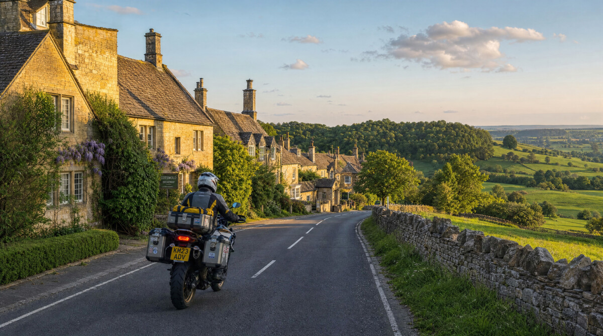
9. Cotswolds Day Loop: Bath to Broadway, Gloucestershire
Distance: 134 miles (loop from Bath via Cheltenham, Broadway, Moreton-in-Marsh, Cirencester and Tetbury)
Best for: Touring, village-to-village riding, accessible day out from the Midlands or M4 corridor
Best time: April to October
The Route
The Cotswolds does not have a single headline road the way the Lake District does. What it has is a network of B-roads and lanes through honey-coloured stone villages across a limestone escarpment that drops away dramatically on its western edge. This loop from Bath covers 134 miles and packs in almost everything the area offers: the escarpment climb, a genuine pass, market towns, and roads that reward a touring pace without demanding technical skill.
From Bath, take the A46 north through Nailsworth, Stroud and Painswick to Cheltenham. From Cheltenham, the B4632 branches northeast, the old A46 alignment, climbing through Winchcombe and up onto the escarpment toward Broadway. From Broadway, the A44 climbs Fish Hill: as close to an Alpine pass as central England gets, with wide sweeping bends opening up as you climb and the Vale of Evesham spreading below to the west.
The return takes a completely different corridor. The A44 east reaches Moreton-in-Marsh in 5 miles, then the A429 Fosse Way runs south through Stow-on-the-Wold to Cirencester. The Fosse Way is a Roman road: well-surfaced, consistent, and faster than the escarpment lanes without losing the Cotswold character. From Cirencester, the A433 southwest runs through Tetbury and past Westonbirt Arboretum back to the A46 and into Bath. The Cotswolds is genuinely busy in summer, particularly in Broadway. Weekday riding gives you a fraction of the traffic.
Scenic tip
Set Scenic to curvy routing from Bath and it will find the B-roads through Painswick and Nailsworth automatically rather than defaulting to the A-roads. The A433 between Cirencester and the A46 is the least-known road on this loop: straight Cotswold limestone country through Tetbury and past Westonbirt Arboretum, light traffic, and a clean run back to Bath.
Ride this route
Start / End (Bath, A46 north junction): 51.3783, -2.3616
Key point (Fish Hill summit, A44): 52.0299, -1.8267
Or get the whole route free here, with Scenic: https://scenicapp.space/route/OUcoiFlu
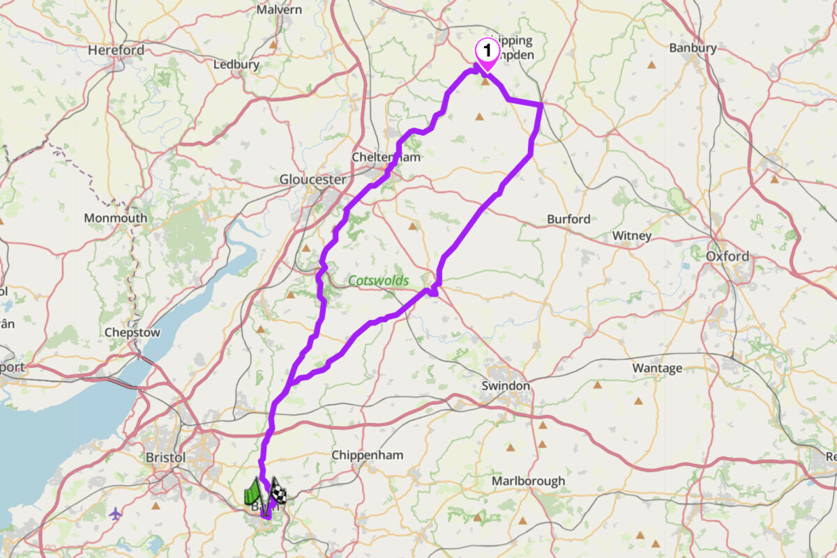
Cotswolds Day Loop — Bath to Chipping Campden, Gloucestershire
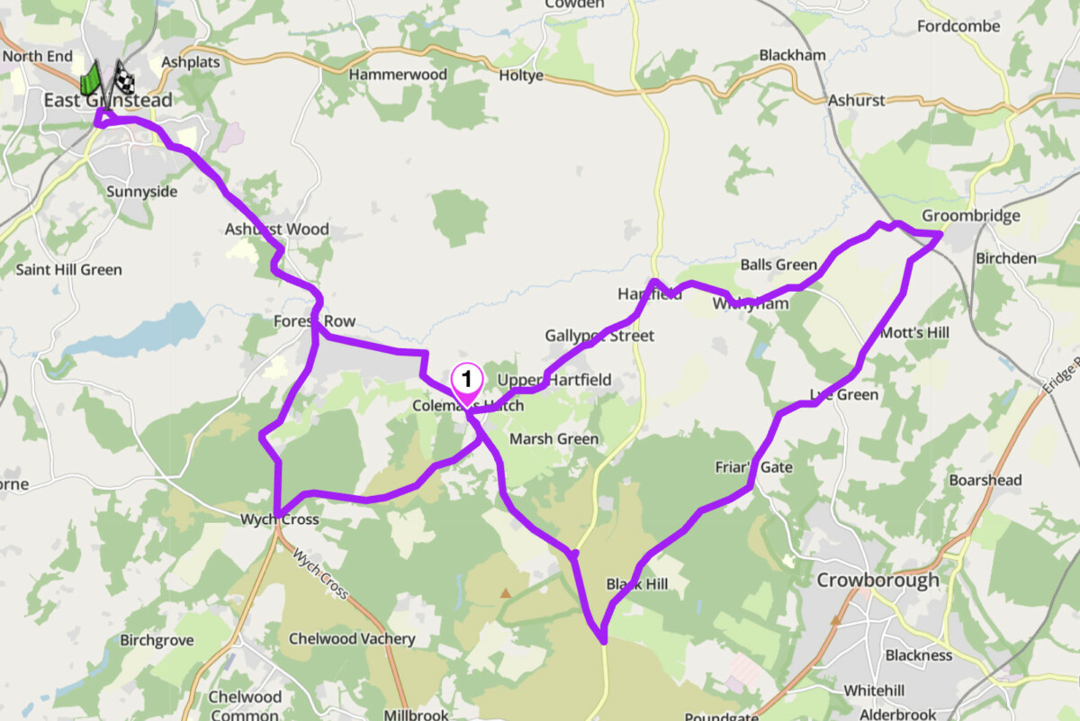
10. Ashdown Forest Loop — B2026 / B2110, East Sussex
Distance: 28 miles (core loop from East Grinstead); 55 miles combined with the Kent border lanes and Groombridge extension
Best for: London-accessible day ride, High Weald lanes, all abilities
Best time: April to October
The Route
Ashdown Forest is the best motorcycle riding within an hour of central London, and it is consistently overlooked in favour of the Surrey Hills or the Kent downs. The forest covers 6,500 acres of the High Weald in East Sussex, and the roads that cross it give you everything the south-east offers on two wheels: fast, flowing single-carriageway lanes through heathland and oak woodland, sudden ridge views across the Weald, and a network of connecting roads that can extend the day in any direction. The area is also the setting for A.A. Milne’s Hundred Acre Wood. This does not affect the quality of the riding.
The A22 south from East Grinstead drops through Forest Row and climbs to Wych Cross, where the forest begins in earnest. Turn left off the A22 and follow Coleman’s Hatch Road past the Ashdown Forest Centre to Coleman’s Hatch. The Hatch Inn is the natural stop here, one of the oldest pubs in Sussex. From Coleman’s Hatch the B2026 climbs south onto the highest point of the forest, with open heathland on both sides. At King’s Standing, pull over and look south: the Weald stretches to the South Downs on a clear day. From there the B2188 drops north on a long, undulating descent through Five Hundred Acre Wood toward Groombridge, passing under a railway bridge before the short climb to the B2110 junction. The return west on the B2110 runs through Hartfield and Coleman’s Hatch back to Forest Row. The A22 north closes the loop.
The core loop is 28 miles. To build a full day, extend east from Groombridge into the Kent border lanes, adding another 30 miles of quieter, more enclosed Wealden riding. The two together make a proper day out without ever touching a dual carriageway.
Scenic tip
At King’s Standing, pull over and look south. The Weald stretches to the South Downs on a clear day, one of the better views in south-east England. Download Scenic’s offline maps before leaving East Grinstead: signal drops out across much of the forest and the junctions around Coleman’s Hatch are easy to misread without navigation.
Ride this route
Start / End (East Grinstead, A22 junction): 51.1253, -0.0077
Key point (Coleman’s Hatch): 51.0853, 0.0684
Or get the whole route free here, with Scenic: https://scenicapp.space/route/TgOYhVDj
Ashdown Forest Loop — B2026 / B2110, East Sussex
Planning Your Ride
Where to base yourself
Ambleside is the natural base for the Lake District passes: Hardknott, Kirkstone and the Wrynose extension are all within 30 minutes. Hawes sits in the middle of the Yorkshire Dales and puts Buttertubs on your doorstep with easy access to the Swaledale and Wharfedale loops. Buxton is 15 minutes from the Cat and Fiddle summit and well-placed for the Snake Pass extension. Brampton in Cumbria sits at the western end of the Military Road with easy access west into the Lakes for a two-region week. Minehead covers Exmoor; Moretonhampstead or Princetown serves Dartmoor. St Ives is the obvious base for the Penwith Peninsula circuit. For the Cotswolds, Bourton-on-the-Water or Burford puts you central to the loop. East Grinstead is practical for Ashdown Forest if coming from London.
Honourable mentions
Two routes that narrowly missed the top ten are worth knowing. The A149 North Norfolk Coast from Hunstanton to Cromer covers 34 miles of single-carriageway road through salt marshes, fishing villages and stretches of coast that are among the finest in England. It is not technically demanding, but the light on this coastline in the early morning is worth a separate trip. Wells-next-the-Sea and Blakeney are the places to stop. The B1010 Burnham Bends in Essex, detailed above in the Ashdown Forest section, is the other. Ten right-angle turns over 1.34 miles near Burnham-on-Crouch: nowhere else in England rides quite like it.
Frequently asked questions
What is the best time of year for motorcycle riding in England? May to September gives the most reliable weather and the widest window of daylight. Late April and October are excellent for emptier roads with better light. Most mountain passes are rideable from late March but carry ice risk until May. The Norfolk coast, the Cotswolds and Ashdown Forest are good almost year-round in terms of road conditions.
Do any of these routes have speed cameras? The Cat and Fiddle (A537) has rear-facing average speed cameras in operation between Macclesfield and the summit, specifically calibrated for motorcycles. Mobile cameras operate on the Snake Pass and several Peak District roads through summer. The Burnham Bends (B1010, Essex) are regularly patrolled.
Are there toll roads on any of these routes? Porlock Hill on the A39 has a parallel toll road as a gentler alternative. As a motorcyclist, take the hill. There are no other tolls on routes in this guide.
Which route is best for an adventure bike? Hardknott Pass and Wrynose are the natural answer, though a heavily loaded large adventure bike and an inexperienced rider should reconsider: the 33% gradient demands low-speed technical confidence. The B3212 Dartmoor, the Military Road and the A39 Exmoor all suit a standard adventure touring setup well.
Which routes work best for riders based in London? Ashdown Forest is the strongest option: 50 minutes from central London and genuine riding. The Cotswolds loop is around 90 minutes. The Burnham Bends in Essex are 45 minutes east and work well as a half-day run. For a longer commitment, the A39 Exmoor is around 3 hours by motorway and worth planning a full weekend around.
How do I use Scenic for route planning in England? Set your start and end points, adjust the curviness slider upward, and download offline maps for the region before departure. Signal is unreliable across all ten of these routes at some point. For the Lake District and Yorkshire Dales, maximum curviness routing takes you off the main A-roads and onto the passes automatically. For Northumberland and the Cotswolds, a moderate setting keeps you on the scenic corridors without adding unnecessary distance.
England has more good roads than any single trip can cover. Pick your region, plan your loop, and go.
Scenic Premium gives you turn-by-turn navigation with curviness routing that finds roads like these automatically, global offline maps so you are covered when signal disappears on the moor, and a rider-focused display designed for a helmet visor glance. Plan your next England ride at scenic.app. Use code Premium15 for 15% off your first year.
If you go, tag us and use the hashtag #ridewithscenic for your chance to win a free Scenic t-shirt.
You have made it to the end of the article. At Scenic we like to reward people who plan their trips properly. If you are not already a premium member, use this code to get 15% off your first year of Scenic Premium: Premium15


