
Several feature requests

Quote from Asphalt on 27.07.2026, 13:16Hi,
Before my trip I purchased the paid subscription, and I used Scenic (Android Beta, July 1–14, 2026) for about 5,600 km of motorcycle riding in Finland, Norway, and Sweden. I gained a lot of practical experience with the app on asphalt, gravel, and forest roads. Many of my observations are based on using the app in rainy conditions. I want to thank you for a great app — it worked well, and I was very satisfied. I definitely recommend SCENIC to anyone considering it!
The app crashed from time to time and restarted automatically. Sometimes the restart took several minutes, but it always eventually came back. A highly appreciated feature is that Ride recording continues exactly from where it left off before the crash. This ensured that the entire Ride was always saved.
I used the app with my phone in landscape mode, mounted slightly angled backwards. I’m not sure whether this was due to the phone, but the compass rose on the screen often showed incorrect directions. It frequently got stuck pointing north (N), even when I was riding in completely different directions, and it didn’t rotate when the direction changed. The compass is especially important when riding on off‑road or forest tracks.
The Track Color (follow‑the‑line) sometimes appeared as the color I had selected in the Settings, but it often changed automatically to another color.
I don’t know if this is due to the mobile phone’s weak GPS signal, but the recorded driving trace often appeared tens of meters off the road, and at intersections it continued straight ahead even when you were actually turning. The line often returned to the correct position only after tens of seconds — sometimes even after a full minute — despite having a clear view of the sky.
Here are some development suggestions that came to mind:
1. Since I use the app in landscape mode, the track or route appears in the right third of the screen, while the left two‑thirds show the map. Could there be a setting that allows placing the route in the middle of the screen (middle/right)? This would allow more map visibility on the right side as well.
2. Before the trip, I saved several hundred My Location markers on the map and along the routes. Importing them from Google My Maps is easy, and mass‑handling them works well.
2.1. If these markers could appear larger on the map in Ride mode, it would be easier to see what type of symbol they represent (e.g., café / attraction / gas station).
2.2. If the markers had also to choose clear, built‑in symbol shortcuts — selectable from a larger set of Scenic’s own icons rather than only phone keyboard emojis. For example: gas station, café, attraction, accommodation, etc. Around 30 basic symbols would likely be enough.
2.3. When such a marker is located, for example, 5 km off the route and not showing on the map when riding, it would be useful if some kind of notification appeared on the screen showing information about that marker — for example that symbol, a direction indicator, and the distance. This would help riders notice before marked places and decide whether to stop or detour.
3. In landscape mode, could there be a small box on the left side of the screen showing the name of the current city/town/village, plus information about the next 1–2 larger towns ahead and the distance to them? This could also appear periodically and stay visible for about 30 seconds.
4. A quick‑access button on the screen to instantly mark a location while riding. This would allow marking, for example, a nice viewpoint while riding, and later adding a name, symbol, and color to the marker.
5. When zooming the map, it would be helpful if street names and road numbers also increased slightly in size. This would make them easier to read in bad conditions.
6. In voice navigation instructions, the Finnish language would sound more natural if the unit (e.g. “metriä”, meters) came immediately after the distance, for example: “Kun 200 metriä on ajettu, käänny vasemmalle kadulle Presidentinkatu.” ("After driving 200 meters, turn left onto Presidentinkatu.") Currently the unit comes at the end: “Kun 200 on ajettu metriä, käänny vasemmalle kadulle Presidentinkatu.” (After 200 has been driven meters, turn left onto Presidentinkatu.)
7. If the app allowed editing a recorded route — for example removing “tails” when riding past a turn and coming back, or correcting sections where the track drifted tens of meters off the road — it would be great to have a “magnet” feature. By clicking a magnet icon, the recorded track could snap to the actual road line visible on the map.This way, you wouldn’t need to edit the route in another app before sharing it onward.
8. In route planning, it would be useful to have an option to start riding the route directly without saving planned route first. This would be helpful in quick situations. The route could automatically be saved into a default folder and named later.
9. I imported and saved very popular Trans Euro Trail (TET) tracks into the app. These tracks in Finland mostly follow gravel roads and forest roads, which are visible on the map which Scenic is using and drivable by car. Route navigation does not follow these tracks precisely, so I had to ride them in follow‑the‑line mode. Would it be possible to add a feature that allows Scenic to treat these tracks as routable routes? In other words, the app could recognize the actual road underneath the track line and provide turn‑by‑turn instructions, especially at intersections.
Hi,
Before my trip I purchased the paid subscription, and I used Scenic (Android Beta, July 1–14, 2026) for about 5,600 km of motorcycle riding in Finland, Norway, and Sweden. I gained a lot of practical experience with the app on asphalt, gravel, and forest roads. Many of my observations are based on using the app in rainy conditions. I want to thank you for a great app — it worked well, and I was very satisfied. I definitely recommend SCENIC to anyone considering it!
The app crashed from time to time and restarted automatically. Sometimes the restart took several minutes, but it always eventually came back. A highly appreciated feature is that Ride recording continues exactly from where it left off before the crash. This ensured that the entire Ride was always saved.
I used the app with my phone in landscape mode, mounted slightly angled backwards. I’m not sure whether this was due to the phone, but the compass rose on the screen often showed incorrect directions. It frequently got stuck pointing north (N), even when I was riding in completely different directions, and it didn’t rotate when the direction changed. The compass is especially important when riding on off‑road or forest tracks.
The Track Color (follow‑the‑line) sometimes appeared as the color I had selected in the Settings, but it often changed automatically to another color.
I don’t know if this is due to the mobile phone’s weak GPS signal, but the recorded driving trace often appeared tens of meters off the road, and at intersections it continued straight ahead even when you were actually turning. The line often returned to the correct position only after tens of seconds — sometimes even after a full minute — despite having a clear view of the sky.
Here are some development suggestions that came to mind:
1. Since I use the app in landscape mode, the track or route appears in the right third of the screen, while the left two‑thirds show the map. Could there be a setting that allows placing the route in the middle of the screen (middle/right)? This would allow more map visibility on the right side as well.
2. Before the trip, I saved several hundred My Location markers on the map and along the routes. Importing them from Google My Maps is easy, and mass‑handling them works well.
2.1. If these markers could appear larger on the map in Ride mode, it would be easier to see what type of symbol they represent (e.g., café / attraction / gas station).
2.2. If the markers had also to choose clear, built‑in symbol shortcuts — selectable from a larger set of Scenic’s own icons rather than only phone keyboard emojis. For example: gas station, café, attraction, accommodation, etc. Around 30 basic symbols would likely be enough.
2.3. When such a marker is located, for example, 5 km off the route and not showing on the map when riding, it would be useful if some kind of notification appeared on the screen showing information about that marker — for example that symbol, a direction indicator, and the distance. This would help riders notice before marked places and decide whether to stop or detour.
3. In landscape mode, could there be a small box on the left side of the screen showing the name of the current city/town/village, plus information about the next 1–2 larger towns ahead and the distance to them? This could also appear periodically and stay visible for about 30 seconds.
4. A quick‑access button on the screen to instantly mark a location while riding. This would allow marking, for example, a nice viewpoint while riding, and later adding a name, symbol, and color to the marker.
5. When zooming the map, it would be helpful if street names and road numbers also increased slightly in size. This would make them easier to read in bad conditions.
6. In voice navigation instructions, the Finnish language would sound more natural if the unit (e.g. “metriä”, meters) came immediately after the distance, for example: “Kun 200 metriä on ajettu, käänny vasemmalle kadulle Presidentinkatu.” ("After driving 200 meters, turn left onto Presidentinkatu.") Currently the unit comes at the end: “Kun 200 on ajettu metriä, käänny vasemmalle kadulle Presidentinkatu.” (After 200 has been driven meters, turn left onto Presidentinkatu.)
7. If the app allowed editing a recorded route — for example removing “tails” when riding past a turn and coming back, or correcting sections where the track drifted tens of meters off the road — it would be great to have a “magnet” feature. By clicking a magnet icon, the recorded track could snap to the actual road line visible on the map.This way, you wouldn’t need to edit the route in another app before sharing it onward.
8. In route planning, it would be useful to have an option to start riding the route directly without saving planned route first. This would be helpful in quick situations. The route could automatically be saved into a default folder and named later.
9. I imported and saved very popular Trans Euro Trail (TET) tracks into the app. These tracks in Finland mostly follow gravel roads and forest roads, which are visible on the map which Scenic is using and drivable by car. Route navigation does not follow these tracks precisely, so I had to ride them in follow‑the‑line mode. Would it be possible to add a feature that allows Scenic to treat these tracks as routable routes? In other words, the app could recognize the actual road underneath the track line and provide turn‑by‑turn instructions, especially at intersections.

Quote from Guido on 28.07.2026, 11:51Thanks for your detailed feedback @asphalt. I appreciate you taking the time.
The app crashed from time to time and restarted automatically. Sometimes the restart took several minutes, but it always eventually came back. A highly appreciated feature is that Ride recording continues exactly from where it left off before the crash. This ensured that the entire Ride was always saved.
Good to hear that resuming the ride worked well. Obviously it would be best if there were no crashes. We'll work on that as we get automated crash reports.
I used the app with my phone in landscape mode, mounted slightly angled backwards. I’m not sure whether this was due to the phone, but the compass rose on the screen often showed incorrect directions. It frequently got stuck pointing north (N), even when I was riding in completely different directions, and it didn’t rotate when the direction changed. The compass is especially important when riding on off‑road or forest tracks.
Hmmm. We don't have any other reports about this. Do you remember if it was when you were moving very slow or not moving, or did this also happen at speeds, let's say, above 20 km/h?
The Track Color (follow‑the‑line) sometimes appeared as the color I had selected in the Settings, but it often changed automatically to another color.
We'll take a look at that.
I don’t know if this is due to the mobile phone’s weak GPS signal, but the recorded driving trace often appeared tens of meters off the road, and at intersections it continued straight ahead even when you were actually turning. The line often returned to the correct position only after tens of seconds — sometimes even after a full minute — despite having a clear view of the sky.
GPS receivers inherently have inaccuracies. Most modern phones however should have a GPS accuracy of about 5 to 10 meter in 'clear sky' conditions. This is probably related to the compass issues mentioned above (GPS receiver also reports heading). It sounds like your GPS is having difficulty getting a clear signal. What phone are you using, and how is it mounted to your bike? The rainy conditions could influence this somewhat, but not to the extent you are describing I believe. Having said that, it could also be a performance issue.
1. Since I use the app in landscape mode, the track or route appears in the right third of the screen, while the left two‑thirds show the map. Could there be a setting that allows placing the route in the middle of the screen (middle/right)? This would allow more map visibility on the right side as well.
This is done on purpose, because the left side of the screen, when you are navigating a route with turn by turn instructions, is used to display the turn by turn instructions and distance and time to arrival panel. I realize when you are following a track you don't have the turn by turn instruction panel, so it might seem that there is a bit of unused space. We'll add it to the list to horizontally center the map origin when following a track / doing follow the line.
2. Before the trip, I saved several hundred My Location markers on the map and along the routes. Importing them from Google My Maps is easy, and mass‑handling them works well.
2.1. If these markers could appear larger on the map in Ride mode, it would be easier to see what type of symbol they represent (e.g., café / attraction / gas station).2.2. If the markers had also to choose clear, built‑in symbol shortcuts — selectable from a larger set of Scenic’s own icons rather than only phone keyboard emojis. For example: gas station, café, attraction, accommodation, etc. Around 30 basic symbols would likely be enough.
2.3. When such a marker is located, for example, 5 km off the route and not showing on the map when riding, it would be useful if some kind of notification appeared on the screen showing information about that marker — for example that symbol, a direction indicator, and the distance. This would help riders notice before marked places and decide whether to stop or detour.
OK. We'll add the to the feature request list.
3. In landscape mode, could there be a small box on the left side of the screen showing the name of the current city/town/village, plus information about the next 1–2 larger towns ahead and the distance to them? This could also appear periodically and stay visible for about 30 seconds.
We'll add that to the list too. Not sure if this is possible as the routing engine is not reporting nearby town names at the moment. We'll dig into this once we have some more time.
4. A quick‑access button on the screen to instantly mark a location while riding. This would allow marking, for example, a nice viewpoint while riding, and later adding a name, symbol, and color to the marker.
This one has been requested a lot and is on the list. Still some more urgent things to tackle though, but it has a high priority.
5. When zooming the map, it would be helpful if street names and road numbers also increased slightly in size. This would make them easier to read in bad conditions.
They already do, but maybe not enough. You will be able to customize this (and much more) with the map customizer. It's already available on iOS, and is in beta for Android. Will be released in a few weeks. Here's more info on the map customizer: https://scenic.app/forum/topic/scenic-4-custom-map-styles/#postid-12240
6. In voice navigation instructions, the Finnish language would sound more natural if the unit (e.g. “metriä”, meters) came immediately after the distance, for example: “Kun 200 metriä on ajettu, käänny vasemmalle kadulle Presidentinkatu.” ("After driving 200 meters, turn left onto Presidentinkatu.") Currently the unit comes at the end: “Kun 200 on ajettu metriä, käänny vasemmalle kadulle Presidentinkatu.” (After 200 has been driven meters, turn left onto Presidentinkatu.)
Unfortunately this is out of our control. The voice instructions are generated by the 3rd party routing engine we are using. I'll open a ticket with them, but can't make any promises.
7. If the app allowed editing a recorded route — for example removing “tails” when riding past a turn and coming back, or correcting sections where the track drifted tens of meters off the road — it would be great to have a “magnet” feature. By clicking a magnet icon, the recorded track could snap to the actual road line visible on the map.This way, you wouldn’t need to edit the route in another app before sharing it onward.
OK. Good suggestion. Will add to the list.
8. In route planning, it would be useful to have an option to start riding the route directly without saving planned route first. This would be helpful in quick situations. The route could automatically be saved into a default folder and named later.
This is already possible. When in plan mode, design your route. Then simply press the back button top left to go to Home Screen, and then tap "ride". The route won't be saved at all. Working on some UI improvements to make this more intuitive.
9. I imported and saved very popular Trans Euro Trail (TET) tracks into the app. These tracks in Finland mostly follow gravel roads and forest roads, which are visible on the map which Scenic is using and drivable by car. Route navigation does not follow these tracks precisely, so I had to ride them in follow‑the‑line mode. Would it be possible to add a feature that allows Scenic to treat these tracks as routable routes? In other words, the app could recognize the actual road underneath the track line and provide turn‑by‑turn instructions, especially at intersections.
Maybe, but this requires some manual work during import. Here's more information on that: https://scenic.app/help/offroad-dual-sport-trail-routes/ and also here: https://scenic.app/help/routes-vs-tracks-and-save-blue-line-as-track-during-import/
Thanks for your detailed feedback @asphalt. I appreciate you taking the time.
The app crashed from time to time and restarted automatically. Sometimes the restart took several minutes, but it always eventually came back. A highly appreciated feature is that Ride recording continues exactly from where it left off before the crash. This ensured that the entire Ride was always saved.
Good to hear that resuming the ride worked well. Obviously it would be best if there were no crashes. We'll work on that as we get automated crash reports.
I used the app with my phone in landscape mode, mounted slightly angled backwards. I’m not sure whether this was due to the phone, but the compass rose on the screen often showed incorrect directions. It frequently got stuck pointing north (N), even when I was riding in completely different directions, and it didn’t rotate when the direction changed. The compass is especially important when riding on off‑road or forest tracks.
Hmmm. We don't have any other reports about this. Do you remember if it was when you were moving very slow or not moving, or did this also happen at speeds, let's say, above 20 km/h?
The Track Color (follow‑the‑line) sometimes appeared as the color I had selected in the Settings, but it often changed automatically to another color.
We'll take a look at that.
I don’t know if this is due to the mobile phone’s weak GPS signal, but the recorded driving trace often appeared tens of meters off the road, and at intersections it continued straight ahead even when you were actually turning. The line often returned to the correct position only after tens of seconds — sometimes even after a full minute — despite having a clear view of the sky.
GPS receivers inherently have inaccuracies. Most modern phones however should have a GPS accuracy of about 5 to 10 meter in 'clear sky' conditions. This is probably related to the compass issues mentioned above (GPS receiver also reports heading). It sounds like your GPS is having difficulty getting a clear signal. What phone are you using, and how is it mounted to your bike? The rainy conditions could influence this somewhat, but not to the extent you are describing I believe. Having said that, it could also be a performance issue.
1. Since I use the app in landscape mode, the track or route appears in the right third of the screen, while the left two‑thirds show the map. Could there be a setting that allows placing the route in the middle of the screen (middle/right)? This would allow more map visibility on the right side as well.
This is done on purpose, because the left side of the screen, when you are navigating a route with turn by turn instructions, is used to display the turn by turn instructions and distance and time to arrival panel. I realize when you are following a track you don't have the turn by turn instruction panel, so it might seem that there is a bit of unused space. We'll add it to the list to horizontally center the map origin when following a track / doing follow the line.
2. Before the trip, I saved several hundred My Location markers on the map and along the routes. Importing them from Google My Maps is easy, and mass‑handling them works well.
2.1. If these markers could appear larger on the map in Ride mode, it would be easier to see what type of symbol they represent (e.g., café / attraction / gas station).2.2. If the markers had also to choose clear, built‑in symbol shortcuts — selectable from a larger set of Scenic’s own icons rather than only phone keyboard emojis. For example: gas station, café, attraction, accommodation, etc. Around 30 basic symbols would likely be enough.
2.3. When such a marker is located, for example, 5 km off the route and not showing on the map when riding, it would be useful if some kind of notification appeared on the screen showing information about that marker — for example that symbol, a direction indicator, and the distance. This would help riders notice before marked places and decide whether to stop or detour.
OK. We'll add the to the feature request list.
3. In landscape mode, could there be a small box on the left side of the screen showing the name of the current city/town/village, plus information about the next 1–2 larger towns ahead and the distance to them? This could also appear periodically and stay visible for about 30 seconds.
We'll add that to the list too. Not sure if this is possible as the routing engine is not reporting nearby town names at the moment. We'll dig into this once we have some more time.
4. A quick‑access button on the screen to instantly mark a location while riding. This would allow marking, for example, a nice viewpoint while riding, and later adding a name, symbol, and color to the marker.
This one has been requested a lot and is on the list. Still some more urgent things to tackle though, but it has a high priority.
5. When zooming the map, it would be helpful if street names and road numbers also increased slightly in size. This would make them easier to read in bad conditions.
They already do, but maybe not enough. You will be able to customize this (and much more) with the map customizer. It's already available on iOS, and is in beta for Android. Will be released in a few weeks. Here's more info on the map customizer: https://scenic.app/forum/topic/scenic-4-custom-map-styles/#postid-12240
6. In voice navigation instructions, the Finnish language would sound more natural if the unit (e.g. “metriä”, meters) came immediately after the distance, for example: “Kun 200 metriä on ajettu, käänny vasemmalle kadulle Presidentinkatu.” ("After driving 200 meters, turn left onto Presidentinkatu.") Currently the unit comes at the end: “Kun 200 on ajettu metriä, käänny vasemmalle kadulle Presidentinkatu.” (After 200 has been driven meters, turn left onto Presidentinkatu.)
Unfortunately this is out of our control. The voice instructions are generated by the 3rd party routing engine we are using. I'll open a ticket with them, but can't make any promises.
7. If the app allowed editing a recorded route — for example removing “tails” when riding past a turn and coming back, or correcting sections where the track drifted tens of meters off the road — it would be great to have a “magnet” feature. By clicking a magnet icon, the recorded track could snap to the actual road line visible on the map.This way, you wouldn’t need to edit the route in another app before sharing it onward.
OK. Good suggestion. Will add to the list.
8. In route planning, it would be useful to have an option to start riding the route directly without saving planned route first. This would be helpful in quick situations. The route could automatically be saved into a default folder and named later.
This is already possible. When in plan mode, design your route. Then simply press the back button top left to go to Home Screen, and then tap "ride". The route won't be saved at all. Working on some UI improvements to make this more intuitive.
9. I imported and saved very popular Trans Euro Trail (TET) tracks into the app. These tracks in Finland mostly follow gravel roads and forest roads, which are visible on the map which Scenic is using and drivable by car. Route navigation does not follow these tracks precisely, so I had to ride them in follow‑the‑line mode. Would it be possible to add a feature that allows Scenic to treat these tracks as routable routes? In other words, the app could recognize the actual road underneath the track line and provide turn‑by‑turn instructions, especially at intersections.
Maybe, but this requires some manual work during import. Here's more information on that: https://scenic.app/help/offroad-dual-sport-trail-routes/ and also here: https://scenic.app/help/routes-vs-tracks-and-save-blue-line-as-track-during-import/
Quote from Asphalt on 29.07.2026, 03:20Quote from Guido on 28.07.2026, 11:51Thank you, Guido, for your responses. It’s real development work when users are listened to! Of course, these were only ideas from my own perspective. Some of them specifically concerned situations where it’s raining, the road is in poor condition, or there’s traffic. In those moments, it doesn’t feel safe or comfortable to stop. Also after using recorded tracks in videos.I used the app with my phone in landscape mode, mounted slightly angled backwards. I’m not sure whether this was due to the phone, but the compass rose on the screen often showed incorrect directions. It frequently got stuck pointing north (N), even when I was riding in completely different directions, and it didn’t rotate when the direction changed. The compass is especially important when riding on off‑road or forest tracks.
Hmmm. We don't have any other reports about this. Do you remember if it was when you were moving very slow or not moving, or did this also happen at speeds, let's say, above 20 km/h?
The compass malfunction occurred at all speeds, and stopping did not change the situation. The tendency to get stuck pointing directly north (the letter N and the red arrow symbol) could last for several hours at a time, and the compass wouldn’t move even when I stopped for a break. This north‑pointing issue also happened while I was driving hundreds of kilometers south on 'clear-sky' conditions.
I don’t know if this is due to the mobile phone’s weak GPS signal, but the recorded driving trace often appeared tens of meters off the road, and at intersections it continued straight ahead even when you were actually turning. The line often returned to the correct position only after tens of seconds — sometimes even after a full minute — despite having a clear view of the sky.
GPS receivers inherently have inaccuracies. Most modern phones however should have a GPS accuracy of about 5 to 10 meter in 'clear sky' conditions. This is probably related to the compass issues mentioned above (GPS receiver also reports heading). It sounds like your GPS is having difficulty getting a clear signal. What phone are you using, and how is it mounted to your bike? The rainy conditions could influence this somewhat, but not to the extent you are describing I believe. Having said that, it could also be a performance issue.
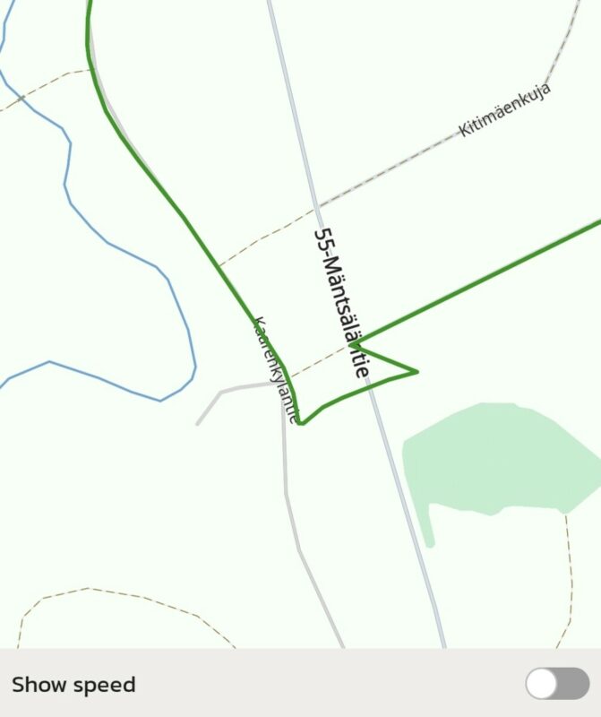
Similarly, I believe that in some situations the issue is caused by poor GPS reception and partly by the phone itself. In particular, this is completely normal for GPS devices on stretches where taller forest or high buildings are close to both sides of the road for an extended period. However, this wasn’t always the case — the issue also occurred while driving through 'clear sky' areas. On the same trip, I occasionally used Google Maps for navigation in similar situations with the same phone. Based on my observations, the location marker seemed to follow the road more accurately. My phone is a Samsung A55 5G 256GB. It is mounted on top of the BMW R1200 GS motorcycle’s navigation bracket, slightly under the windscreen. I’m including an example (pic) where I was riding from the north, turned onto the road marked with a dashed line, and continued east. In this case, the wandering of the track was under 100 meters, and it corrected itself when I stopped to yield to crossing traffic. The sky view at that location can be seen from the following link: https://maps.app.goo.gl/oyHEUZzMckdVA1GP6 I want to emphasize, that the route was drawn on the map perfectly well and accurately enough, so this is not a major issue.
7. If the app allowed editing a recorded route — for example removing “tails” when riding past a turn and coming back, or correcting sections where the track drifted tens of meters off the road — it would be great to have a “magnet” feature. By clicking a magnet icon, the recorded track could snap to the actual road line visible on the map.This way, you wouldn’t need to edit the route in another app before sharing it onward.
OK. Good suggestion. Will add to the list.
1) For these extra U‑loops, a simple solution would be the ability to select two route points and click “scissors,” which would remove all route points between them and connect those two points directly. If possible, Scenic could also automatically suggest such spots on the route where two route points appear close together within a short distance in both directions, and ideally allow removing the U‑loop with a single click. The connection would naturally occur at an appropriate intersection.
2) Correcting a route line that wanders away from the road (GPS error) could often be done in the same way: selecting two route points and deleting the points in between. However, if the road is winding or curving, it would be better if Scenic itself could recognize the road and move the route roughly onto it by creating new route points or adjusting existing ones and removing unnecessary ones.
3) It would also be a very useful feature if single route or several points could be simultaneously moved, deleted or added.
Another extremely useful feature would be the ability to merge two or more separate route recordings. In other words, the endpoint of Route A would connect to the starting point of Route B, forming a new route whose starting point is the original start of Route A and whose endpoint is the original end of Route B. I ended up with several routes on the same day that continued from the previous route’s endpoint, partly because I was cautious about not losing a multi‑hour continuous recording or other reasons. This could be implemented under My Rides > actions > Merge Rides, after which you could select two or more routes to merge, resulting in a new combined route saved to the list.
8. In route planning, it would be useful to have an option to start riding the route directly without saving planned route first. This would be helpful in quick situations. The route could automatically be saved into a default folder and named later.
This is already possible. When in plan mode, design your route. Then simply press the back button top left to go to Home Screen, and then tap "ride". The route won't be saved at all. Working on some UI improvements to make this more intuitive.
Sorry, my mistake not to understand this. Great!
9. I imported and saved very popular Trans Euro Trail (TET) tracks into the app. These tracks in Finland mostly follow gravel roads and forest roads, which are visible on the map which Scenic is using and drivable by car. Route navigation does not follow these tracks precisely, so I had to ride them in follow‑the‑line mode. Would it be possible to add a feature that allows Scenic to treat these tracks as routable routes? In other words, the app could recognize the actual road underneath the track line and provide turn‑by‑turn instructions, especially at intersections.
Maybe, but this requires some manual work during import. Here's more information on that: https://scenic.app/help/offroad-dual-sport-trail-routes/ and also here: https://scenic.app/help/routes-vs-tracks-and-save-blue-line-as-track-during-import/
I'll study this!
Quote from Guido on 28.07.2026, 11:51
I used the app with my phone in landscape mode, mounted slightly angled backwards. I’m not sure whether this was due to the phone, but the compass rose on the screen often showed incorrect directions. It frequently got stuck pointing north (N), even when I was riding in completely different directions, and it didn’t rotate when the direction changed. The compass is especially important when riding on off‑road or forest tracks.
Hmmm. We don't have any other reports about this. Do you remember if it was when you were moving very slow or not moving, or did this also happen at speeds, let's say, above 20 km/h?
The compass malfunction occurred at all speeds, and stopping did not change the situation. The tendency to get stuck pointing directly north (the letter N and the red arrow symbol) could last for several hours at a time, and the compass wouldn’t move even when I stopped for a break. This north‑pointing issue also happened while I was driving hundreds of kilometers south on 'clear-sky' conditions.
I don’t know if this is due to the mobile phone’s weak GPS signal, but the recorded driving trace often appeared tens of meters off the road, and at intersections it continued straight ahead even when you were actually turning. The line often returned to the correct position only after tens of seconds — sometimes even after a full minute — despite having a clear view of the sky.
GPS receivers inherently have inaccuracies. Most modern phones however should have a GPS accuracy of about 5 to 10 meter in 'clear sky' conditions. This is probably related to the compass issues mentioned above (GPS receiver also reports heading). It sounds like your GPS is having difficulty getting a clear signal. What phone are you using, and how is it mounted to your bike? The rainy conditions could influence this somewhat, but not to the extent you are describing I believe. Having said that, it could also be a performance issue.
Similarly, I believe that in some situations the issue is caused by poor GPS reception and partly by the phone itself. In particular, this is completely normal for GPS devices on stretches where taller forest or high buildings are close to both sides of the road for an extended period. However, this wasn’t always the case — the issue also occurred while driving through 'clear sky' areas. On the same trip, I occasionally used Google Maps for navigation in similar situations with the same phone. Based on my observations, the location marker seemed to follow the road more accurately. My phone is a Samsung A55 5G 256GB. It is mounted on top of the BMW R1200 GS motorcycle’s navigation bracket, slightly under the windscreen. I’m including an example (pic) where I was riding from the north, turned onto the road marked with a dashed line, and continued east. In this case, the wandering of the track was under 100 meters, and it corrected itself when I stopped to yield to crossing traffic. The sky view at that location can be seen from the following link: https://maps.app.goo.gl/oyHEUZzMckdVA1GP6 I want to emphasize, that the route was drawn on the map perfectly well and accurately enough, so this is not a major issue.
7. If the app allowed editing a recorded route — for example removing “tails” when riding past a turn and coming back, or correcting sections where the track drifted tens of meters off the road — it would be great to have a “magnet” feature. By clicking a magnet icon, the recorded track could snap to the actual road line visible on the map.This way, you wouldn’t need to edit the route in another app before sharing it onward.
OK. Good suggestion. Will add to the list.
1) For these extra U‑loops, a simple solution would be the ability to select two route points and click “scissors,” which would remove all route points between them and connect those two points directly. If possible, Scenic could also automatically suggest such spots on the route where two route points appear close together within a short distance in both directions, and ideally allow removing the U‑loop with a single click. The connection would naturally occur at an appropriate intersection.
2) Correcting a route line that wanders away from the road (GPS error) could often be done in the same way: selecting two route points and deleting the points in between. However, if the road is winding or curving, it would be better if Scenic itself could recognize the road and move the route roughly onto it by creating new route points or adjusting existing ones and removing unnecessary ones.
3) It would also be a very useful feature if single route or several points could be simultaneously moved, deleted or added.
Another extremely useful feature would be the ability to merge two or more separate route recordings. In other words, the endpoint of Route A would connect to the starting point of Route B, forming a new route whose starting point is the original start of Route A and whose endpoint is the original end of Route B. I ended up with several routes on the same day that continued from the previous route’s endpoint, partly because I was cautious about not losing a multi‑hour continuous recording or other reasons. This could be implemented under My Rides > actions > Merge Rides, after which you could select two or more routes to merge, resulting in a new combined route saved to the list.
8. In route planning, it would be useful to have an option to start riding the route directly without saving planned route first. This would be helpful in quick situations. The route could automatically be saved into a default folder and named later.
This is already possible. When in plan mode, design your route. Then simply press the back button top left to go to Home Screen, and then tap "ride". The route won't be saved at all. Working on some UI improvements to make this more intuitive.
Sorry, my mistake not to understand this. Great!
9. I imported and saved very popular Trans Euro Trail (TET) tracks into the app. These tracks in Finland mostly follow gravel roads and forest roads, which are visible on the map which Scenic is using and drivable by car. Route navigation does not follow these tracks precisely, so I had to ride them in follow‑the‑line mode. Would it be possible to add a feature that allows Scenic to treat these tracks as routable routes? In other words, the app could recognize the actual road underneath the track line and provide turn‑by‑turn instructions, especially at intersections.
Maybe, but this requires some manual work during import. Here's more information on that: https://scenic.app/help/offroad-dual-sport-trail-routes/ and also here: https://scenic.app/help/routes-vs-tracks-and-save-blue-line-as-track-during-import/
I'll study this!
Quote from Guido on 29.07.2026, 10:51OK. Thanks for the additional information. Scenic doesn't snap the raw GPS location to roads on the map at this moment in time. That is one reason why you might see "drift". This doesn't explain the compass issue though, so there is something wrong there. We'll investigate this.
Thanks for your suggestion on the recorded ride editing. We'll take those into account when we start working on that (which may be a while as there are many more things on the list still, especially for Android).
OK. Thanks for the additional information. Scenic doesn't snap the raw GPS location to roads on the map at this moment in time. That is one reason why you might see "drift". This doesn't explain the compass issue though, so there is something wrong there. We'll investigate this.
Thanks for your suggestion on the recorded ride editing. We'll take those into account when we start working on that (which may be a while as there are many more things on the list still, especially for Android).


