
The best motorcycle roads in New Zealand’s South Island cross three mountain ranges, two coastlines and one gravel high road that only opens for four months a year. Motorcycle touring here rewards riders who treat the island as a loop rather than a list: alpine passes at 900 to 1,300 metres, temperate rainforest running straight into glacier ice, and a coastline that swings from fiord to petrified forest. This guide covers ten routes across the island, verified for distance, altitude, season and road number, from the country’s most famous drive to a private-land toll road that closes for winter entirely.
In this guide:
Contents
1. Milford Road — SH94, Fiordland
Distance: 119 km (74 miles), Te Anau to Milford Sound
Altitude: 945 m
Best for: benchmark riding, glacial scenery, single-road destinations
Best time: November to April
The Route:
There is exactly one road to Milford Sound, and this is it. From Te Anau the road runs the eastern shore of the lake before entering the Eglinton Valley, a wide glacial floor with the Earl Mountains on both sides. Past Mirror Lakes and Lake Gunn the valley narrows, and the road climbs to the Homer Tunnel: a 1.2 km bore through solid granite at 945 m, unlined, on a 1-in-10 gradient, opened in 1953 after nineteen years of construction and the only way through. It drops into the Cleddau Valley beneath 800 m rock walls, past The Chasm, and out to the fiord at Milford Sound, where Mitre Peak rises straight from the water.
Fill up in Te Anau. Ride early: the road empties before the day-tour buses arrive from Te Anau and Queenstown, and cloud tends to build over the fiord by early afternoon. In winter, NZTA runs avalanche control at the tunnel corridor, usually in the morning, and closures can run to a couple of hours; check the road status before you leave. Snow chains may be compulsory near the tunnel between May and September. Sandflies are constant at Milford Sound itself; keep moving or cover up.
Scenic tip:
Stop at Mirror Lakes in the first hour of light. Wind picks up through the Eglinton Valley from mid-morning, and the reflection only holds while the surface is still.
Ride this route:
Start (Te Anau): -45.4145, 167.7183
Summit (Homer Tunnel): -44.7648, 167.9885
End (Milford Sound): -44.6682, 167.9268
Or get the whole route free here, with Scenic: https://scenicapp.space/route/fSKcBNoc
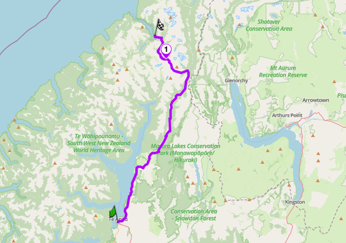
Milford Road, SH94, Fiordland
2. Crown Range Road — SH89, Otago
Distance: 67 km (42 miles), Wanaka to Queenstown
Altitude: 1,121 m
Hairpins: 7 (Arrowtown-side climb, locally “the zig-zag”)
Best for: technical alpine riding, gold-rush history
Best time: November to April
The Route:
New Zealand’s highest sealed main road connects Wanaka and Queenstown over a single pass, sealed only in the late 1990s; before that it was gravel. From the Wanaka side the road climbs steadily through the Cardrona Valley past the historic Cardrona Hotel, one of the country’s oldest pubs. The summit sits on the Crown Terrace, a broad, farmed plateau, before the road drops away in seven hairpins toward Arrow Junction and Arrowtown. That descent is the reason riders come: tight, exposed, and with the Wakatipu Basin and the Remarkables laid out below.
There is only one passing bay on the entire road, about 5 km south of Cardrona, and it only serves traffic travelling Wanaka to Queenstown. Ride that direction if you want it. The road is busy in summer with campervans unused to the hairpins; ride early or late in the day. Between May and September the summit regularly ices over and carrying chains is standard practice, even though the road is rarely closed outright. Kea gather at the summit car park and will investigate mirrors and seals; do not feed them.
Scenic tip:
Stop at the Cardrona Hotel on the way up, not the way down. It is the last flat, easy parking before the climb starts in earnest, and the beer garden has the same view you are about to ride into.
Ride this route:
Start (Wanaka): -44.6944, 169.1418
Summit (Crown Saddle): -44.9920, 168.9388
End (Queenstown): -45.0302, 168.6614
Or get the whole route free here, with Scenic: https://scenicapp.space/route/eacmpWcf
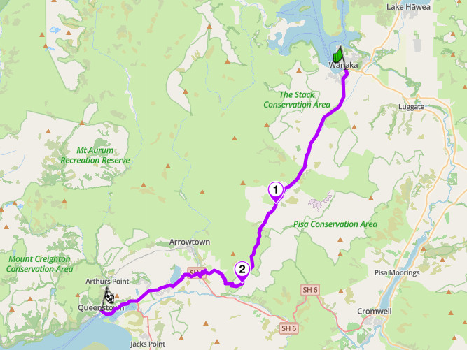
Crown Range Road, SH89, Otago
3. Arthur’s Pass — SH73, Canterbury/West Coast
Distance: 245 km (152 miles), Christchurch to Greymouth
Altitude: 920 m
Best for: engineering, national park scenery, an alpine benchmark ride
Best time: November to April
The Route:
The highest and most direct of the South Island’s three alpine crossings, and the one the TranzAlpine railway parallels for its 223 km run between Christchurch and Greymouth. The eastern approach climbs steadily across the Canterbury high country before the road tightens through Arthur’s Pass National Park to the summit at 920 m. The western descent through the Otira Gorge is the highlight: the Otira Viaduct, completed in 1999, spans 440 m of ground too unstable to hold a conventional road, replacing a section that used to close after every heavy rain.
Ride either direction; the gorge works well both ways, though descending it westbound gives you the viaduct in front of you rather than behind. Fuel at Springfield, Arthur’s Pass village or Otira on the way through. Rockfall and snow can close the road at short notice in winter, and NZTA periodically closes it for daytime resurfacing work; check before you travel.
Scenic tip:
Devil’s Punchbowl Falls is a short, well-formed walk from Arthur’s Pass village, 20 minutes each way to a 131 m waterfall. It is the easiest genuinely spectacular stop on the whole crossing.
Ride this route:
Start (Christchurch): -43.5319, 172.6366
Summit (Arthur’s Pass): -43.0281, 171.6313
End (Greymouth): -42.4613, 171.1988
Or get the whole route free here, with Scenic: https://scenicapp.space/route/hWENWGoa
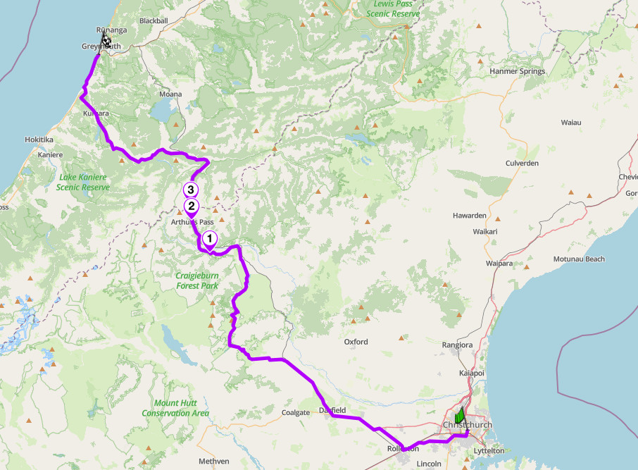
Arthur’s Pass, SH73, Canterbury/West Coast
4. Lewis Pass — SH7, Canterbury/West Coast
Distance: around 140 km (87 miles), Hanmer Springs to Reefton
Altitude: 907 m
Best for: an underrated pass, forest riding, hot pools
Best time: November to April
The Route:
The northernmost of the South Island’s three Southern Alps crossings, and the one most riders skip. Where Arthur’s Pass is dramatic and Haast is low and easy, Lewis Pass is quiet: a beech-forested climb through the Lewis Pass National Scenic Reserve to a gentle 907 m saddle, with none of the engineering drama of its neighbours. There is no viaduct here and no postcard hairpin, just tall red beech closing in on both sides of the road and a soft, unhurried gradient to the top. It was a Maori and early European trade route before being formed as a road during the 1930s Depression, built by relief labour rather than any grand engineering scheme, and it remains the least-trafficked way across the range, carrying a fraction of the traffic Arthur’s Pass sees in the same season.
Use this as the alternative when Arthur’s Pass is closed for weather or roadworks; it adds time but rarely has the same restrictions. Fuel at Hanmer Springs, Springs Junction or Reefton. Deer and other livestock stray onto the road in the forested sections, especially at dawn and dusk. The road is a genuine decompression ride after Arthur’s Pass or the Crown Range: wide, well-sighted, and easy to underestimate on a bike that wants more of a workout.
Scenic tip:
Maruia Springs, a few kilometres west of the summit, is a rustic hot pool complex with Japanese-style bathhouses and outdoor rock pools. Stop here rather than pushing straight through to Hanmer Springs’ more commercial pools.
Ride this route:
Start (Hanmer Springs): -42.1194, 171.8624
Summit (Lewis Pass): -42.3856, 172.3998
End (Reefton): -42.5257, 172.8288
Or get the whole route free here, with Scenic: https://scenicapp.space/route/uUzsmTGI
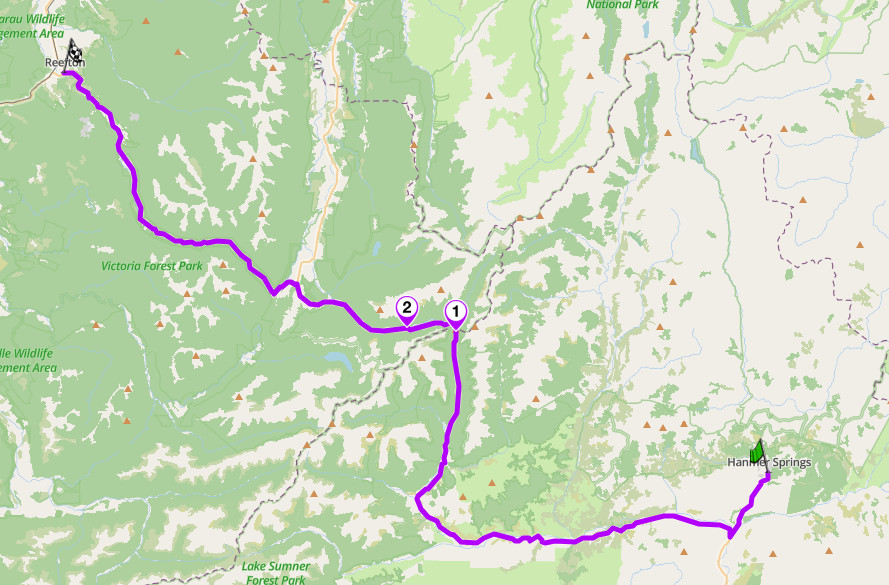
Lewis Pass, SH7, Canterbury/West Coast
5. Haast Pass — SH6, West Coast/Otago
Distance: around 145 km (90 miles), Haast to Wanaka
Altitude: 562 m
Best for: waterfalls, easy technicality, rainforest-to-lake touring
Best time: year-round, best November to April
The Route:
The lowest and gentlest of the South Island’s alpine passes, and a genuine change of pace after Arthur’s Pass or the Crown Range. From the coast at Haast the road follows the Haast River inland through temperate rainforest, part of the Te Wahipounamu World Heritage Area, climbing so gradually to its 562 m summit that many riders miss the moment they cross it. The reward is a run of short, well-marked stops clustered around the summit itself: Fantail Falls, Thunder Creek Falls, and the Blue Pools, a turquoise river pool reached by a swing bridge. Further east the road opens onto Lake Wanaka.
Ride either direction; there is no technical reason to prefer one way over the other. Fuel at Haast, Makarora or Wanaka. Rain is frequent and can be heavy on the coastal side; the waterfalls are more dramatic for it, but expect wet tarmac. Sandflies at Haast are a genuine nuisance at any stop; keep moving or cover exposed skin.
Scenic tip:
The Blue Pools walk, a short loop off the road with a swing bridge over glacier-fed water so clear the trout are visible from above. Twenty minutes there and back, and the best stop on the whole crossing.
Ride this route:
Start (Haast): -43.8796, 169.0435
Summit (Haast Pass): -44.1077, 169.3546
End (Wanaka): -44.6932, 169.1409
Or get the whole route free here, with Scenic: https://scenicapp.space/route/rTrnIEox
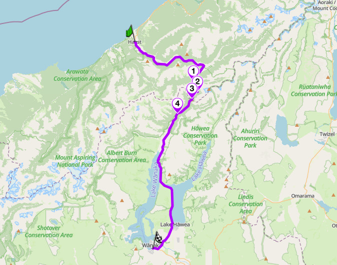
Haast Pass, SH6, West Coast/Otago
6. Lindis Pass — SH8, Mackenzie/Central Otago
Distance: around 110 km (68 miles), Omarama to Cromwell
Altitude: 971 m
Best for: open high country, an underrated inland alternative
Best time: year-round, occasional winter chains
The Route:
Everything else in this guide is forest, coast or granite. Lindis Pass is neither alpine nor coastal: it crosses dry, golden tussock country between the Mackenzie Basin and Central Otago, and the emptiness is the point. Despite sitting in the dry interior rather than the main divide, it is the highest point on the South Island’s state highway network, and the road rewards a rider who is not chasing hairpins: long sweeping curves through open country with almost nothing built on it. The only structures for kilometres at a time are the odd fence line and the occasional merino flock working its way across the hillside.
Wind is the main hazard, not gradient: crosswinds pick up through the open tussock sections and can catch a loaded bike off guard. Snow and ice are possible at the summit even in summer, more likely than the altitude alone suggests, so check conditions if the forecast looks marginal. Fuel at Omarama or Cromwell.
Scenic tip:
Ride it in the last hour of light. The tussock turns gold in low sun in a way that photographs well and that most riders miss entirely, because they treat this as a road to get through rather than a road to ride.
Ride this route:
Start (Omarama): -44.4876, 169.9655
Summit (Lindis Pass): -44.5865, 169.6478
End (Cromwell): -45.0466, 169.1958
Or get the whole route free here, with Scenic: https://scenicapp.space/route/bJUzdJXO
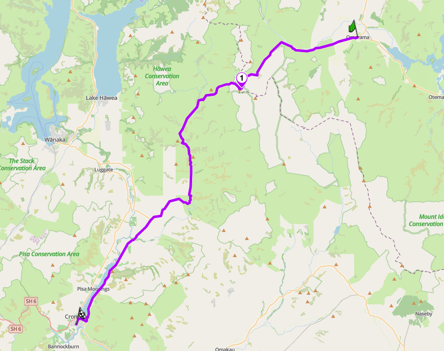
Lindis Pass, SH8, Mackenzie/Central Otago
7. Catlins Coast (Southern Scenic Route) — SH92, Southland
Distance: around 178 km (110 miles), Invercargill to Balclutha via the coast
Best for: remote coastal touring, wildlife, waterfalls
Best time: October to April
The Route:
The wildest coastline in this guide, and the one with the least traffic. The Southern Scenic Route runs from Invercargill through the Catlins to Balclutha, threading between native forest and exposed headlands, with almost every side road leading to a waterfall, a beach or a wildlife stop. Curio Bay has a 160-million-year-old petrified forest visible at low tide, and yellow-eyed penguins and Hector’s dolphins both use the bay. Slope Point, a short detour off the main road, marks the southernmost point of the South Island and is worth the stop for that alone. Nugget Point, a short drive east from the main route, is a lighthouse on a narrow headland with fur seals and sea lions below it.
Fuel is thin: Owaka is the main service town in the Catlins itself, so don’t rely on finding a station between the main towns at either end. Weather changes fast and the coast is exposed; carry wet-weather gear regardless of the forecast. Wildlife rules matter here: seals and sea lions haul out on beaches and roads alike, and DOC signage asks visitors to keep well back. Cathedral Caves, if you want to add the detour, are only accessible at low tide and only in season; check times before you commit to it.
Scenic tip:
Curio Bay at dusk. Yellow-eyed penguins come ashore in the evening, and the petrified forest at low tide is genuinely striking rather than a roadside curiosity.
Ride this route:
Start (Invercargill): -46.4127, 168.3503
End (Balclutha): -46.2357, 169.7445
Or get the whole route free here, with Scenic: https://scenicapp.space/route/uphOUZTD
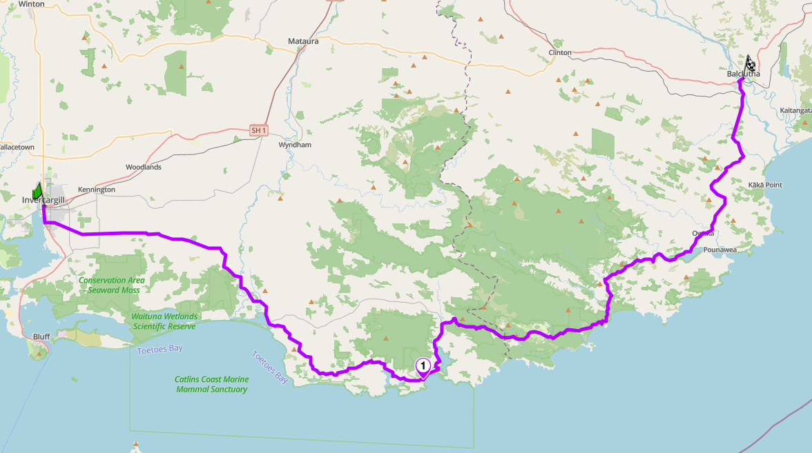
Catlins Coast (Southern Scenic Route), SH92, Southland
8. Queen Charlotte Drive — SH6, Marlborough
Distance: around 35 km (22 miles), Picton to Havelock
Best for: sounds-side coastal riding, a ferry-gateway entry
Best time: year-round, sealed
The Route:
The first real riding most visitors do in the South Island, since it sits directly off the Cook Strait ferry terminal at Picton. The road climbs and drops over three low saddles between Queen Charlotte Sound and Pelorus Sound, with turquoise water visible through native bush for most of its length. It is short, but it earns its place here as the natural on-ramp to everything else in this guide, and it is a good road in its own right, not just a formality.
Standard satnav routing will send you the long way round via Blenheim, because it is technically faster; ignore it if the coast road is what you came for. Watch for cyclists: the Link Pathway shadows much of the drive and is popular. The road is narrow with limited shoulder in places, so keep a margin on the bends, particularly on the Havelock side where lookouts encourage sudden stops.
Scenic tip:
Cullen Point Lookout, near the Havelock end. It is signposted with typical Kiwi understatement as just “lookout,” but the view across Pelorus Sound from there is the best on the road. Picton is a hub, not just a through-point: use Explore to build a loop that continues past Havelock and back to Picton via Blenheim and SH1, rather than riding the same 35 km out and back.
Ride this route:
Start (Picton): -41.2913, 174.0054
End (Havelock): -41.2866, 173.7671
Or get the whole route free here, with Scenic: https://scenicapp.space/route/wePlEkdj
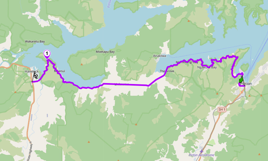
Queen Charlotte Drive, SH6, Marlborough
9. Glacier Highway — SH6, West Coast
Distance: 276 km (171 miles), Haast to Hokitika via Fox Glacier and Franz Josef
Best for: rainforest-to-glacier contrast, remote West Coast touring
Best time: November to April, subject to washout closures year-round
The Route:
Nothing else in this guide puts glacier ice this close to sea level. The road runs the length of the West Coast between Haast and Hokitika, with the Southern Alps rising directly off the Tasman Sea on one side. Fox Glacier and Franz Josef, 25 minutes apart, both descend from the icefield toward temperate rainforest, though both have retreated well up their valleys in recent decades; expect a longer walk to the ice than older guides suggest. Along the way, Knights Point and Bruce Bay give open coastal views, and Lake Matheson near Fox Glacier is a still-water mirror lake with a view of Aoraki/Mount Cook on a clear morning.
The fuel gap between Fox Glacier and Haast is 120 km with nothing in between; fill up before you leave. Rain is frequent and can be heavy, and the road has a history of washouts, including a 2019 bridge failure at Franz Josef that closed the highway for weeks. Single-lane bridges are common, some shared with rail traffic; watch for signage. Sandflies are a serious nuisance at every stop; don’t linger with your helmet off near still water.
Scenic tip:
Lake Matheson, a 90-minute loop walk near Fox Glacier village. Go at first light for the mirror reflection of Aoraki/Mount Cook and Mount Tasman, before wind disturbs the surface. Go offline before you leave Franz Josef: coverage is patchy to nonexistent for most of the run south to Haast, and this is a road with washout history, so having the maps already downloaded is the safer play, not just the convenient one.
Ride this route:
Start (Haast): -43.8800, 169.0425
End (Hokitika): -42.7156, 170.9682
Or get the whole route free here, with Scenic: https://scenicapp.space/route/SrXnPcjh
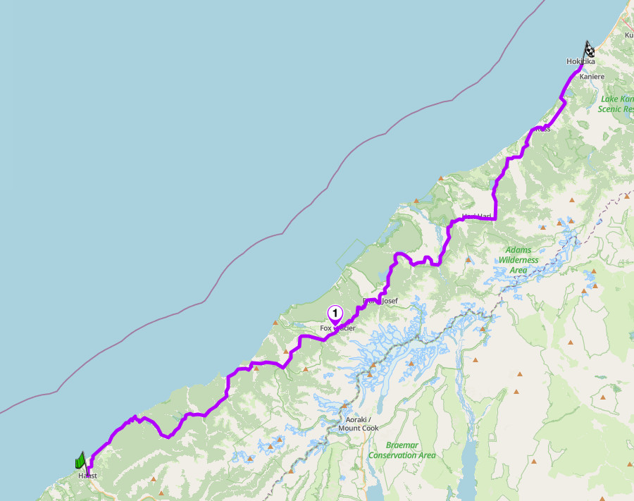
Glacier Highway, SH6, West Coast
10. Rainbow Road — Nelson Lakes/Canterbury
Distance: 112 km (70 miles), gravel, private toll road, Hanmer Springs to St Arnaud
Altitude: 1,347 m at Island Saddle, New Zealand’s highest public road
Best for: adventure and gravel riding, remote high country
Best time: 26 December to Easter Monday only. Closed to the public outside this window.
The Route:
The one genuinely off-tarmac entry in this guide, and a hard contrast to everything else on the list. Rainbow Road crosses Molesworth and Rainbow Stations, both working high-country farms, on a road built in the 1950s to service an electricity transmission line. It climbs from either end to Island Saddle at 1,347 m, the highest publicly accessible road in New Zealand, before dropping to the other valley. It is unsealed for its full length, fords several streams, and passes through a narrow gorge locally known as Hell’s Gate.
This is a toll road on private land: pay at the Rainbow Station gate, around NZ$20 for a motorcycle. It is only open to the public from 26 December to Easter Monday each year. There are no services anywhere on the route, so carry fuel, and water crossings can run deep after rain. Snow is possible at the saddle at any time of year. Check whether your travel or rental insurance actually covers this road before you ride it; several standard policies exclude it by name.
Scenic tip:
Lake Tennyson, a short detour near Island Saddle. A glacial moraine lake at the headwaters of the Clarence River, and one of the few spots on the whole road with an easy place to stop and take it in.
Ride this route:
Start (Hanmer Springs): -42.5295, 172.8311
Summit (Island Saddle): -42.1776, 172.7913
End (St Arnaud): -41.8012, 172.8478
Or get the whole route free here, with Scenic: https://scenicapp.space/route/rDZTFuoE
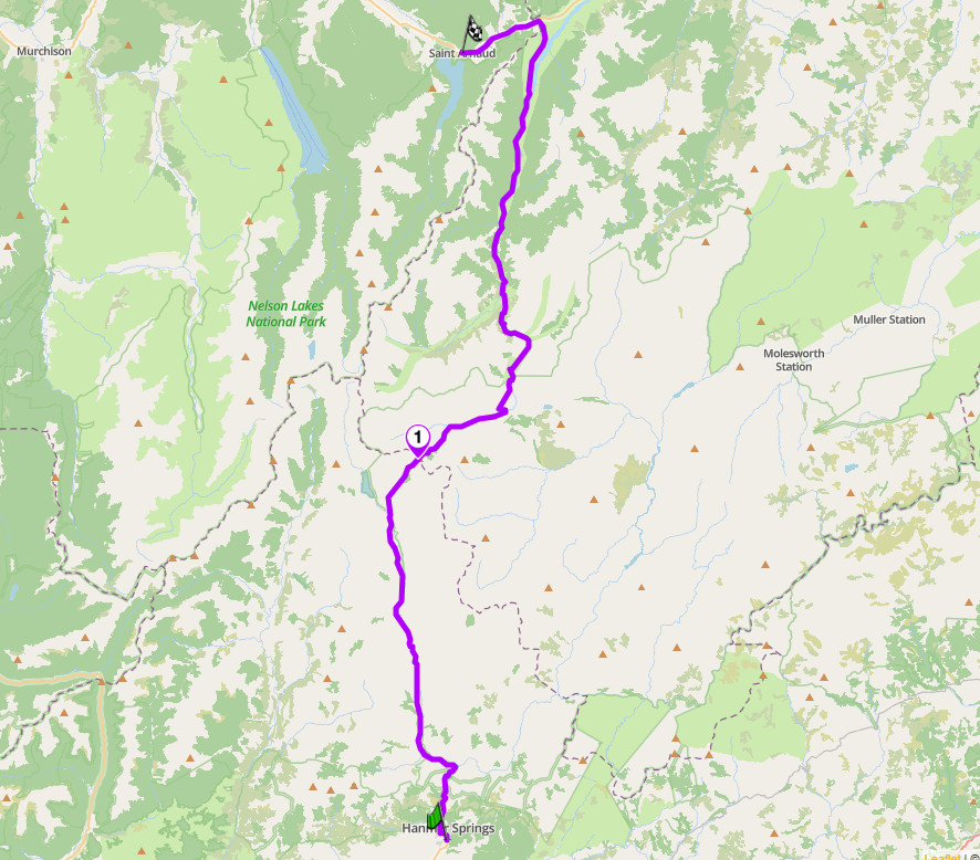
Rainbow Road, Nelson Lakes/Canterbury
Planning Your Ride
The South Island’s riding season runs roughly November to April. Outside that window, alpine passes carry snow and ice risk, Rainbow Road is closed outright, and several West Coast sections are more prone to washout closures. Summer (December to February) brings the most reliable weather and the most traffic; shoulder months either side give quieter roads at some cost to certainty.
New Zealand requires a full motorcycle licence or an appropriately endorsed international driving permit; a car licence does not cover a motorcycle regardless of engine size. Helmets are mandatory. Headlights on at all times is not currently a blanket legal requirement but is strongly advised given how many of these roads run through cloud, forest shade or rain. There are no tolls on any state highway in this guide; Rainbow Road’s access fee is a private arrangement with the landholder, not a government toll.
Mobile coverage is patchy to nonexistent on Rainbow Road, the Catlins, and long stretches of the West Coast. If you’re building routes yourself before you arrive, Scenic’s Import brings in Google Maps links, GPX, KML, KMZ, GDB or ITN files from a tour operator or riding partner, and Go offline lets you download the South Island sections before you lose signal rather than finding out you need them mid-ride.
Where to base yourself
Queenstown. The best base for the Crown Range, Lindis Pass and the southern lakes district, with full services and easy access to Milford Road via Te Anau.
Christchurch. The natural base for Arthur’s Pass and Lewis Pass, and the arrival point for most riders flying into the South Island.
Wanaka. Sits at the crossroads of Haast Pass, the Crown Range and the Lindis Pass, with a quieter, less touristed feel than Queenstown.
Hanmer Springs. The right base for both Lewis Pass and Rainbow Road, with hot pools to recover in after either.
Frequently asked questions
What is the best motorcycle road in the South Island? Milford Road has the strongest claim: it is the country’s most recognised drive and the only road to one of its most famous destinations. Riders chasing technical corners more often name the Crown Range or Arthur’s Pass.
When is Rainbow Road open? Only from 26 December to Easter Monday each year. It is closed to the public outside that window, and a toll applies to the section on Rainbow Station land.
Do I need a permit for any of these roads? No permits are required for any route in this guide. A correctly endorsed licence or international driving permit is required to ride at all.
Which of these roads are gravel? Only Rainbow Road. Every other route in this guide is fully sealed.
What is the hardest route here? Rainbow Road, by some distance: unsealed, seasonal, tolled, and with water crossings and no services. Among the sealed roads, the Crown Range is the most technical.
Do I need an adventure bike? Only for Rainbow Road, where ground clearance and suitable tyres matter. Every other route in this guide suits a standard touring bike.
The South Island fits more genuinely different riding into one landmass than almost anywhere else in this series: fiord, glacier, tussock and gravel, all within a few hours of each other. Pick your base, check the season, and go.
Scenic Premium gives you turn-by-turn navigation with a rider-focused display you can customise, global offline maps, and automatic curvy routing that finds the mountain road rather than the valley shortcut. On three of the routes above there is little or no mobile signal for long stretches, which is exactly the case for having the maps on the phone rather than in the cloud.
If you go, tag us and use the hashtag #ridewithscenic for your chance to win a free Scenic t-shirt.
You’ve made it to the end of the article! At Scenic we like to reward people who plan their trips properly. If you’re not already a premium member, use this code to get 20% off your first year of Scenic Premium: ScenicBlog20


