
The Best Motorcycle Roads in the World: Top 10 Routes
The best motorcycle roads in the world are not all in the Alps. Motorcycle touring rewards riders who look further than one mountain range: a 5,328 m pass in Ladakh, 1,240 km of Patagonian ripio, a one-lane ledge cut into the High Atlas in 1932 and never widened since. This guide ranks ten routes across six continents for motorcycle riding, from single-day climbs to multi-day expeditions, with verified distances, altitudes, pass opening dates and start and end coordinates for every one. Five of the ten take more than a day. Each one verified, each one worth the flight.
Two notes on what is in and what is out. We have ranked these on the quality of the riding first, the scale of the journey second, and how well known they are only as a tiebreak. And the Stelvio Pass is not here. It is one of the ten best roads on earth and it leads our Italy guide, so this is where to read about that route. The road that took the title of world’s greatest driving road off the Stelvio is at number one.
Our friends at Furkot have made this helpful map of all the routes mentioned in this guide. We think they’re great, you can see why:
In this guide:
Contents
10. Great Ocean Road — B100, Victoria, Australia
Distance: 243 km (151 miles), Torquay to Allansford
Best for: coastal touring, decompression, sightseeing
Best time: October to November, or late March to May
The Route:
It opens the countdown because it is the most famous road here and the least demanding to ride. Built between 1919 and 1932 by more than 3,000 returned First World War servicemen, working with picks, shovels and horse-drawn carts, it is widely described as the world’s largest war memorial. Howard Hitchcock, the Geelong mayor who part-funded it, died before it was finished. The riding is the 45 km between Lorne and Apollo Bay, cut into the cliff face at Mount Defiance and Cape Patton, with corners running from long sweepers to second-gear tight. West of Apollo Bay the road climbs inland through the Otways to Lavers Hill, then returns to the coast at Princetown for the Twelve Apostles and the Shipwreck Coast.
Ride westbound, Torquay to Allansford. The ocean sits to the south, so westbound keeps you in the seaward lane for the whole route, with every lookout a left turn and no oncoming traffic to cross. Leave Torquay at first light and clear Lorne to Apollo Bay before 09:30, ahead of the Melbourne coach tours. Avoid weekends and Victorian school holidays. Victoria runs the tightest speed camera tolerance in Australia, and the Twelve Apostles precinct carries a seasonal 40 km/h zone that is actively enforced.
Fuel is at Anglesea, Lorne, Apollo Bay, Lavers Hill and Port Campbell only, with gaps of up to 48 km between them. Sea fog is common on winter mornings and can cut visibility on the cliff bends. Rockfall closes the Lorne to Apollo Bay section after heavy rain, so check VicTraffic before you set off. Kangaroos are worst on the Port Campbell section in late afternoon.
Scenic tip:
Kennett River, on the cliff section. Park at Kafe Koala and walk up Grey River Road, the most reliable place to see wild koalas on the road, best early morning or late afternoon. Continue to Mount Defiance Lookout for the best view of the cliff road itself. For the Twelve Apostles without the crowds, stay overnight at Port Campbell and shoot them at sunrise instead.
Ride this route:
Start (Torquay): -38.3142, 144.3172
End (Allansford): -38.3847, 142.6066
Or get the whole route free here, with Scenic: https://scenicapp.space/viewRoute.php?rid=MCAPEXin
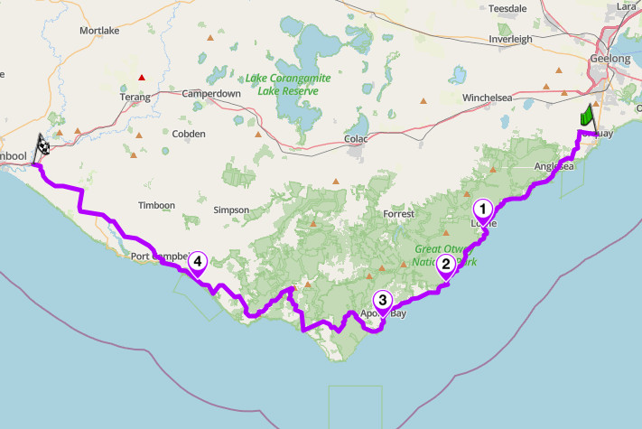
Great Ocean Road: B100, Victoria, Australia
9. Mae Hong Son Loop — Route 1095, Northern Thailand
Distance: 600 km (370 miles) loop from Chiang Mai. Five days.
Altitude: around 1,450 m (4,757 ft) at the Doi Kiew Lom ridge
Best for: continuous corners, multi-day touring, small-capacity bikes
Best time: November to February
The Route:
Three road numbers carry the loop. The 107 starts you off, running out of Chiang Mai before a left turn on to the 1095 which climbs from there through Pai. The 108 then takes you through Mae Hong Son and Mae Sariang before looping back to the start. The 1095 was originally cut by the Imperial Japanese Army in the Second World War. The famous curve counts painted on welcome signs do not survive scrutiny: use the physical numbered curve markers on the 1095 instead, where the Doi Kiew Lom viewpoint sits at curve 681. Doi Inthanon, Thailand’s highest point, is not on this loop: it is a 95 km round trip off Chom Thong.
Ride anticlockwise, Pai first, so the hardest riding comes on fresh legs and the wide, flowing 108 becomes the decompression run home. Ride November to February only: the burning season runs February to April and Mae Hong Son province is consistently worse for air quality than Chiang Mai. The named hazard is minivans on the Chiang Mai to Pai shuttle, which cut blind corners on the 1095, along with gravel on blind bends after the monsoon and no lighting on the mountain sections after dark. Fuel appears every 40 to 50 km and is thinnest between Pai and Mae Hong Son. An international driving permit with category A marked is required; a car licence does not cover a motorcycle here.
Scenic tip:
Chiang Mai has good roads radiating out in every direction, so the loop does not have to be the only plan. Use Explore to build round trips out of the city with curvy routing on, and try the Samoeng loop on the 107, 1096 and 1269 as a shakedown ride the day before you leave.
Ride this route:
Start and end (Chiang Mai, Tha Phae Gate): 18.7878, 98.9933
Summit (Doi Kiew Lom viewpoint, curve 681): 19.4455, 98.3193
Or get the whole route free here, with Scenic: https://scenicapp.space/route/damRIeYB
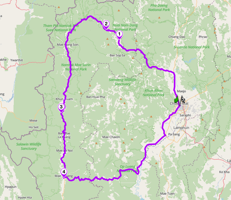
Mae Hong Son Loop: Route 1095, Northern Thailand
8. Tizi n’Test and the High Atlas — N7, Morocco
Distance: 637 km (395 miles) loop from Marrakech. Four to five days.
Altitude: 2,093 m (6,867 ft) at Tizi n’Test
Key passes: Tizi n’Test (2,093 m, N7), Tizi n’Tichka (2,205 m, N9)
Best for: exposure, adventure touring, Berber High Atlas
Best time: April to early June, late September to October
The Route:
The N7 was built between 1926 and 1932 as a French colonial military road and has never been widened: one vehicle wide in places, no barriers, no markings, 500 m drops as routine. The pass tops out at 2,093 m by survey, with a cafe at the summit because there is nowhere else to stop. What follows is a continuous 1,600 m descent to Taroudant, off the red rock and onto the green Souss plain. Ride it as a loop rather than a transit: over the N7, then back over the Tizi n’Tichka, North Africa’s highest major pass at 2,205 m and the faster, better-surfaced Atlas crossing.
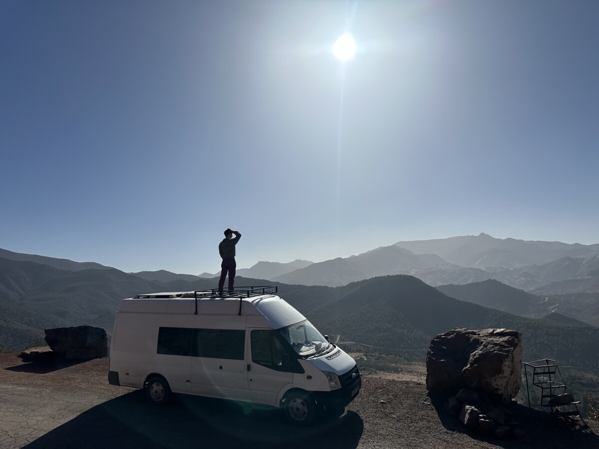
Joe and Rose in the Tizi n Test Pass in 2024
The 2023 Al Haouz earthquake was epicentred in this valley, and the route still shows corrugations, ruts, loose stone and active repair works, so verify condition close to your departure date. Snow blocks Tizi n’Test in winter, typically December to March, and landslides follow heavy rain: do not ride it after rain or arrive at the pass after dark. Goat and sheep herds stand on the carriageway rather than beside it, and the summit is usually in cloud with crosswinds at altitude. Ride uphill where you have the choice for better sightlines. Fuel and basic amenities run through Asni, Ouirgane, Ijoukak and Ouled Berhil, with Taroudant, a walled town with riads and a hospital, the right overnight stop.
Scenic tip:
Ask any satnav for Marrakech to Taroudant and it will send you round on the motorway. Turn on curvy routing and it takes the N7 over the pass instead. While planning, drop a stop at the Tin Mal mosque at Ijoukak, twelfth century and missed by most riders because the road bends away just before the turning. Riders with a spare day can detour into Ouarzazate itself for the UNESCO-listed Taourirt Kasbah and the Atlas Film Studios, though it means leaving the direct line between Taliouine and the Tichka junction.
Ride this route:
Start and end (Marrakech, Jemaa el-Fna): 31.6260, -7.8891
Summit (Tizi n’Test): 30.8592, -8.3714
Or get the whole route free here, with Scenic: https://scenicapp.space/route/cjSDornh
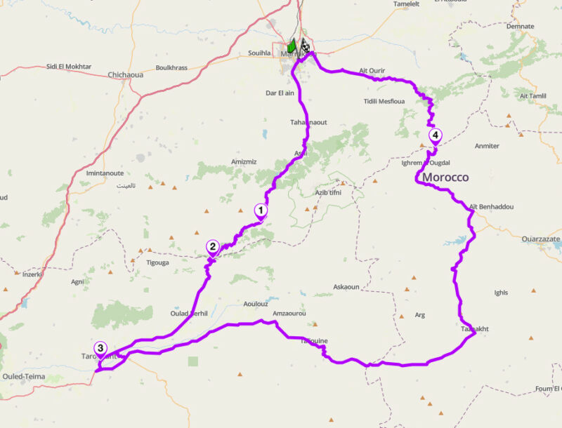
Tizi N’Test and the High Atlas: N7, Morocco
7. Manali to Leh Highway — NH3, India
Distance: 427 km (265 miles), Manali to Leh via the Atal Tunnel. Three days.
Altitude: 5,328 m (17,480 ft) at Tanglang La
Hairpins: 21 (Gata Loops)
Key passes: Baralacha La (4,890 m), Nakee La (4,739 m), Lachulung La (5,059 m), Tanglang La (5,328 m)
Best for: high-altitude adventure, Himalayan touring, adventure bikes
Best time: mid-June to September
The Route:
Four passes above 4,700 m in under 430 km, topping out at Tanglang La at 5,328 m. The route starts through the Atal Tunnel, which cut 46 km off the old alignment over the Rohtang La. Beyond Keylong the road empties out. The Gata Loops stack 21 hairpins into 10.3 km, then Nakee La, Lachulung La, the descent into Pang, and the More Plains, around 40 km of flat gravel at over 4,500 m with nothing in between. This is not a corner road: it is the highest sustained road riding most people will ever do.
Ride south to north, Manali to Leh, so you gain altitude in stages. Altitude is what hurts people here, not the surface: you reach 5,328 m from Manali’s 2,050 m in under 400 km. Do not sleep at Sarchu, whatever the tent camps tell you; break at Jispa or Keylong instead. The first day covers barely 70 km to Keylong, but it puts around 1,000 m of climbing behind you, over the Atal Tunnel at roughly 3,000 m, and that is the point: stop there and let your body adjust before the passes start. The road opens around 14 May and closes around 20 November. Water crossings are worst in the afternoon once meltwater comes down, so ride them in the morning. The fuel gap is the real constraint: 323 km from Tandi to Karu with nothing between. No permit is required for the highway itself, though side trips to Nubra, Pangong, Tso Moriri and Hanle need a Protected Area Permit through a Leh agency.
Scenic tip:
The More Plains. Most riders hammer across the dull bit between Pang and Debring. Stop in the middle instead and switch the engine off: it is the quietest place on the route and the part people describe years later.
Ride this route:
Start (Manali): 32.2433, 77.1890
Summit (Tanglang La): 33.5084, 77.7697
End (Leh): 34.1525, 77.5762
Or get the whole route free here, with Scenic: https://scenicapp.space/route/LKhpSiQt
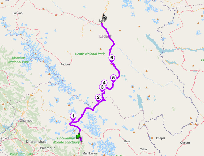
Manali to Leh Highway: NH3, Himachal Pradesh and Ladakh, India
6. Carretera Austral — CH-7, Patagonia, Chile
Distance: 1,234 km (767 miles), Puerto Montt to Villa O’Higgins. Ten to fourteen days.
Best for: expedition touring, ripio, fjord and steppe
Best time: November to April
The Route:
Ruta 7 runs from Puerto Montt to Villa O’Higgins, where it simply stops: there is no onward road for motorcycles. The northern end is fjord and rainforest. The middle brings the Queulat hanging glacier and the run to Coyhaique, the only city on the route. South of Villa Cerro Castillo the tarmac gives out and the best of it starts: the turquoise shoreline of Lago General Carrera, the marble caves at Puerto Rio Tranquilo, then high steppe to Cochrane. Three ferries are mandatory: Caleta La Arena, running constantly and unbooked; Hornopiren to Caleta Gonzalo, a four-and-a-half-hour crossing that must be booked ahead; and Puerto Yungay to Rio Bravo, free but limited outside peak season.
Ride November to April, southern hemisphere summer, and book beds three weeks ahead in January and February. Ride north to south, so gravel confidence builds at roughly the rate the road demands it. Ripio is the whole game: loose gravel, washboard and dust from oncoming vehicles that can drop visibility to nothing, so back off and let it clear. Fuel runs through most towns, but the longest gap, Cochrane to Villa O’Higgins at around 230 km with the Yungay ferry in the middle, needs care. Fourteen days, three ferry timetables and a bed each night is more planning than a route file can hold; our partners at Furkot are built for exactly that, building the days and bookings before you bring the riding into Scenic.
Scenic tip:
Use Plan and drop the three ferry ramps in as fixed via points rather than trusting a route line to find them, since all three sit off the obvious through-line. Add the Capillas de Marmol turning and the Rio Baker confluence viewpoint too, both easy to ride straight past at ripio concentration levels.
Ride this route:
Start (Puerto Montt): -41.4715, -72.9424
End (Villa O’Higgins): -48.4661, -72.5591
Or get the whole route free here, with Scenic: https://scenicapp.space/route/SSvLApxt
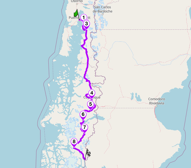
Carretera Austral: CH-7, Patagonia, Chile
5. Beartooth Highway — US 212, Montana and Wyoming
Distance: 111 km (69 miles), Red Lodge to Cooke City
Altitude: 3,337 m (10,947 ft) at Beartooth Pass
Best for: alpine sweepers, high-altitude touring, Yellowstone access
Best time: late May to early October
The Route:
Charles Kuralt called it the most beautiful drive in America in 1994, and nobody has found a better line since. Out of Red Lodge the road climbs 1,580 m to 3,337 m in 19 km, averaging over 9%, first through the Rock Creek switchbacks and then onto the plateau. Above the treeline it becomes 20 km of wide-radius third-gear sweepers across open alpine tundra at over 3,000 m, with lakes and snowfields and nothing in the way. It drops into Cooke City, four miles from Yellowstone’s north-east entrance: the best way into the park and the least used. No verified switchback count exists for this road.
The season is short and set by the plough: it opens the Friday of Memorial Day weekend and closes around Columbus Day. Ride it west from Red Lodge so the two big climbs come first. Snow squalls are possible at 3,300 m in any month of the open season, and you will lose fifteen degrees or more between Red Lodge and the pass, so carry layers you can put on at the summit. Frost heave and gravel patches are worst on the Wyoming plateau. There is no fuel between Red Lodge and Cooke City, the full 111 km, so these two towns are the only services on the route.
Scenic tip:
Rock Creek Vista Point, on the climb out of Red Lodge, is a short paved walk to a view straight back down the switchbacks: the best photograph on the road. Then, rather than retracing your route, drop onto the Chief Joseph Scenic Byway and run it back into Wyoming. It is emptier than the Beartooth and almost nobody plans it in.
Ride this route:
Start (Red Lodge): 45.1868, -109.2461
Summit (Beartooth Pass): 44.9688, -109.4711
End (Cooke City): 45.0196, -109.9347
Or get the whole route free here, with Scenic: https://scenicapp.space/route/ILnztnZQ
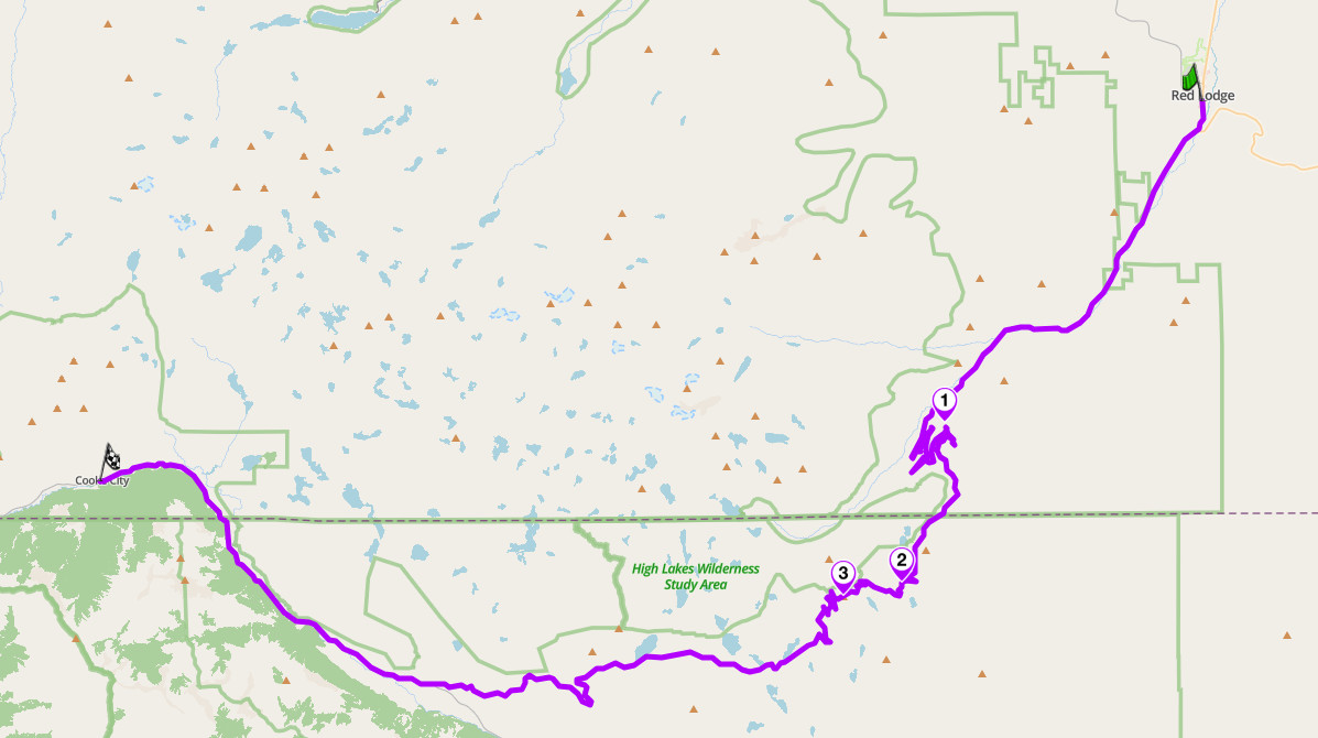
Beartooth Highway: US 212, Montana and Wyoming
4. Pamir Highway — M41, Tajikistan and Kyrgyzstan
Distance: 723 km (449 miles), Khorog to Osh. Five to seven days.
Altitude: 4,655 m (15,272 ft) at Ak-Baital
Key passes: Koitezek (4,122 m), Naizatash (4,134 m), Ak-Baital (4,655 m), Kyzyl-Art (4,280 m), Taldyk (3,615 m)
Best for: remote adventure, gravel, expedition riding
Best time: June to September
The Route:
Ak-Baital at 4,655 m is the highest road pass in the former Soviet Union, and the M41 is the second-highest international highway anywhere. From Khorog, the last real town in the western Pamirs, the road climbs onto the plateau and simply stays up, above 3,500 m, for days. Murghab is the only settlement of any size. Then Kyzyl-Art, the border post, 20 km of no-man’s-land, and the drop through Sary-Tash into Osh. The appeal is not the road itself but that for hundreds of kilometres there is nothing else. A Wakhan Corridor variant exists, but current security guidance advises staying clear of the Afghan border, so the northern line through Alichur and Murghab is the one described here.
A GBAO permit is mandatory for foreign riders on top of the Tajik visa, arranged alongside an e-visa. Without it you are turned back at real military checkpoints. Altitude is worse than the Himalaya because it does not let up: four consecutive nights above 3,500 m. Fuel is at Khorog, Alichur, Murghab and Sary-Tash, with gaps of over 200 km and poor fuel quality throughout. Ak-Baital is rough gravel with deep potholes, and the approach to Kyzyl-Art has around 20 km of mud and creek crossings. Accommodation is homestays, unevenly spaced, and our partners at Furkot are built for exactly that constraint: breaking a long route into days that end somewhere you can sleep.
Scenic tip:
Go offline before you leave Khorog. There is little to no cellular coverage across the plateau, and you are riding a road with unsigned junctions and 200 km between anything. Download the full Tajik and Kyrgyz sections while you still have wifi, and check the download before you climb rather than after.
Ride this route:
Start (Khorog): 37.4872, 71.5903
Summit (Ak-Baital): 38.5586, 73.5926
End (Osh): 40.5165, 72.8030
Or get the whole route free here, with Scenic: https://scenicapp.space/route/trhQSRtK
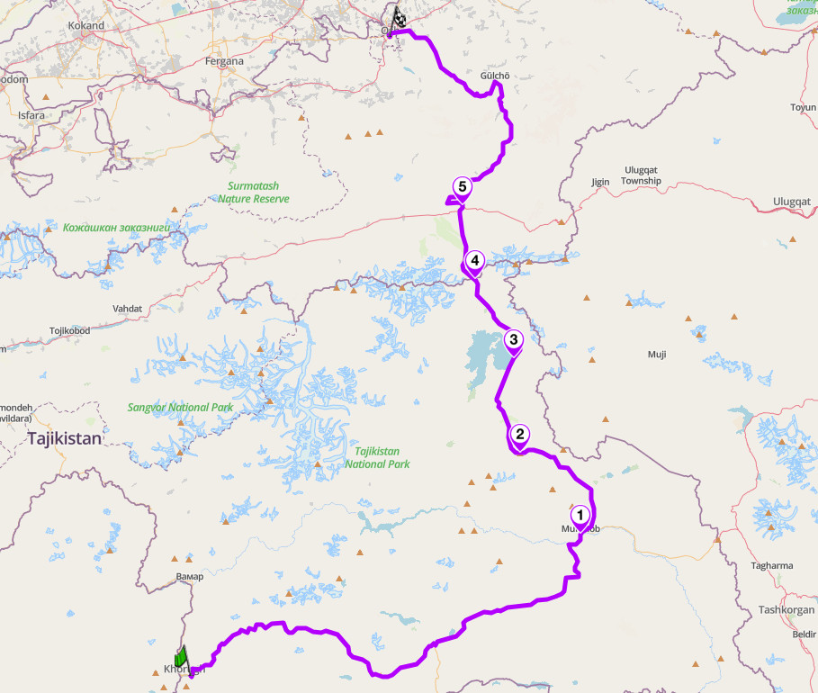
Pamir Highway — M41, Tajikistan and Kyrgyzstan
3. Furka, Grimsel and Susten — Hauptstrasse 19, 6 and 11, Switzerland
Distance: 120 km (75 miles) loop from Andermatt, with 3,600 m (11,800 ft) of climbing. One long day.
Altitude: 2,429 m (7,969 ft) at Furka
Hairpins: 25 across the Furka alone, 15 on the Realp ramp and 10 on the Gletsch side
Key passes: Furka (2,429 m), Susten (2,224 m), Grimsel (2,164 m)
Best for: technical passes, one-day loops, engineering
Best time: mid-June to mid-October
The Route:
Three passes above 2,100 m, 120 km, and 3,600 m of climbing, all inside one day from a single base. The Furka is the theatre: fifteen hairpins climbing the Realp ramp, then ten more stacked below the shuttered Hotel Belvedere with the Rhone Glacier behind, where Goldfinger was filmed in 1964. The Grimsel is a short sprint onto bare granite then down past dam architecture. The Susten is the good one, purpose-built between 1938 and 1945 for motor traffic rather than widened from a mule track, held to a 9% maximum gradient throughout, the engineers routing it 7 km longer than the old bridle path purely to keep the gradients gentle.
Ride it anticlockwise from Andermatt, taking the Furka’s east ramp uphill while the road is still empty and finishing on the Susten’s best half, fast and flowing down to Wassen. Start by 07:30, before coach and camper traffic builds, and avoid weekends, when the passes fill with sports cars and Uri police run targeted enforcement. All three passes typically open by late May or June, but closing dates are never published in advance: Swiss cantons close at short notice on the first real snowfall. The Susten has around 25 unlit tunnels with almost no crash barriers, and cyclists are everywhere on this bucket-list loop.
Scenic tip:
A bend above Realp is signposted James Bond Strasse, marketed as the Goldfinger Curve, where Bond watched Goldfinger’s Rolls-Royce in 1964.
Ride this route:
Start and end (Andermatt): 46.6339, 8.5936
Summit (Furka Pass): 46.5723, 8.4149
Summit (Grimsel Pass): 46.5614, 8.3369
Summit (Susten Pass): 46.7295, 8.4470
Or get the whole route free here, with Scenic: https://scenicapp.space/route/vmWqwBBX
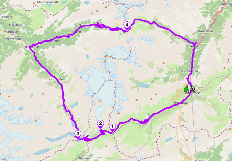
Furka, Grimsel and Susten: Hauptstrasse 19, 6 and 11, Switzerland
2. The Trollstigen Road — Fv63, More og Romsdal, Norway
Distance: 104 km (65 miles), Andalsnes to Geiranger
Altitude: around 855 m (2,805 ft) at Stigrora
Hairpins: 11
Best for: fjord touring, coastal scenery, photography
Best time: late May to September
The Route:
Which half of this road is the best is a live argument. There are eleven hairpins, each named for the foreman who built it, climbing 840 m out of Isterdalen with the Stigfossen waterfall dropping beside the road and passing beneath it. At the top, Trollstigen has a visitor centre and three architect-designed viewing platforms hanging over the drop. Then the road becomes something else: the Gudbrandsjuvet gorge, the orchards at Valldal, the Linge to Eidsdal ferry, and the Ornesvingen switchbacks dropping into Geiranger. Two roads in one, and the second half is why you ride all 104 km rather than just the eleven bends.
Rockfall closed Trollstigen in June 2024 and it missed most of 2025; after safety works it reopened on 27 April 2026. No major rockfall-protection scheme is funded yet, so it still closes at short notice when heavy rain is forecast: check vegvesen.no on the morning you ride. Ride south from Andalsnes. Coaches pack the hairpins between 10:00 and 16:00 in July and August, and the tarmac in the waterfall spray zone stays wet and polished all day. The Linge to Eidsdal ferry is mandatory unless you want a long detour, and it takes bikes without booking.
Scenic tip:
Ride it after 18:00 in June or July. The coaches are gone, the plateau empties, and Stigfossen faces west so the low light comes straight down the waterfall. At that latitude you have usable daylight past 22:00, so you can do Trollstigen at seven and the Ornesvingen switchbacks at nine and still eat in Geiranger.
Ride this route:
Start (Andalsnes): 62.5673, 7.6869
Summit (Trollstigen, Stigrora): 62.4550, 7.6661
End (Geiranger): 62.1009, 7.2058
Or get the whole route free here, with Scenic: https://scenicapp.space/route/vpWmczfj
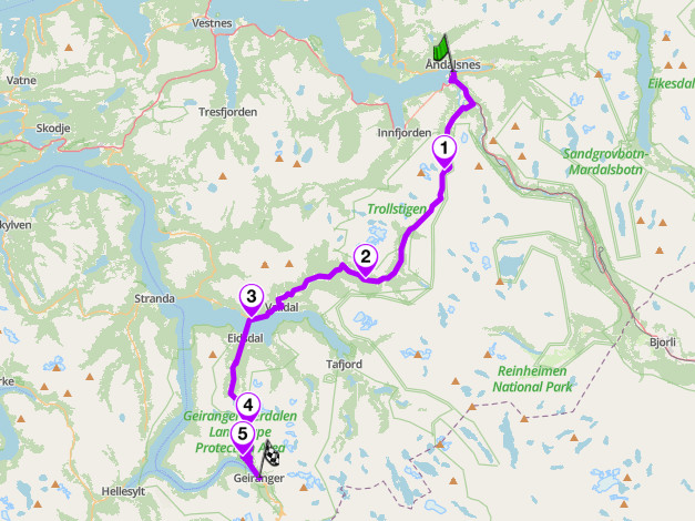
The Trollstigen Road — Fv63, More og Romsdal, Norway
1. Transfagarasan — DN7C, Romania
Distance: 115 km (71 miles), Curtea de Arges to Cartisoara
Altitude: 2,042 m (6,700 ft) at the Balea tunnel
Best for: technical alpine, day rides, Carpathian touring
Best time: late June to October
The Route:
Top Gear took the title of world’s greatest driving road off the Stelvio and gave it to this road in 2009. Jeremy Clarkson called it the most amazing road he had ever seen, and years later nothing has taken the title back. Built in the early 1970s as a strategic military crossing, it carries 27 viaducts and five tunnels across 90 km of mountain. From Curtea de Arges the south side is fast and flowing, forested sweepers along Lake Vidraru. Above Balea Cascada it changes completely: tight switchbacks stacked on open alpine grass with the whole climb visible above you at once. No reliable hairpin count exists, so the stats block omits the row.
Ride south to north, saving the switchbacks for last. The alpine sector is officially closed from 1 November to 30 June, reopening by inspection rather than calendar; in 2026 it opened 12 June and runs 07:00 to 21:00 only, with night traffic banned outright. Bears are a real hazard on the carriageway, and CNAIR issued a specific 2026 alert against stopping to feed them. Fog and sleet arrive above 1,800 m in any month of the season, and the Balea tunnel is wet and unlit, so drop your speed before you enter. Coach traffic clogs the road between Balea Cascada and Balea Lake from mid-morning.
Scenic tip:
Poenari Castle, on the south side below the Vidraru dam: 1,480 steps up from a car park most riders go straight past, and the actual fortress of Vlad III, not the Bran Castle the coaches queue for. Go early, before the tour groups.
Ride this route:
Start (Curtea de Arges): 45.1408, 24.6732
Summit (Balea Lake): 45.6042, 24.6161
End (Cartisoara): 45.7286, 24.5752
Or get the whole route free here, with Scenic: https://scenicapp.space/route/xjhZGnOj
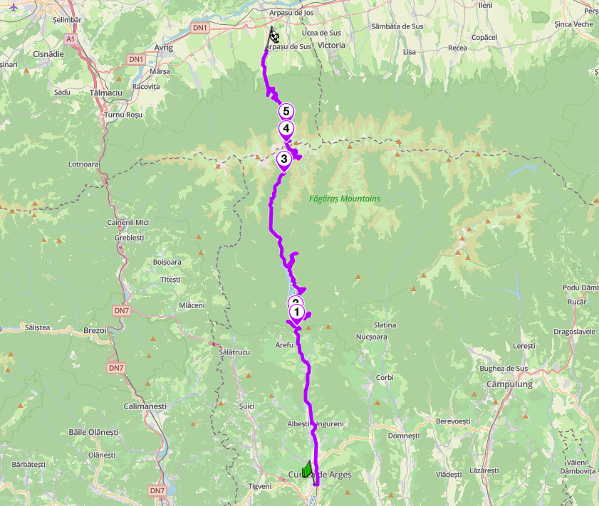
Transfagarasan: DN7C, Carpathians, Romania
Planning Your Ride
This guide spans both hemispheres, so there is no closed season overall, but each pass has a short one. Northern summer, roughly mid-June to September, is the window for the Carpathians, Norway, the Swiss passes, Montana, the Himalaya and the Pamir. Southern summer, November to April, is when Patagonia and the Great Ocean Road work, and Southeast Asia runs on the dry season, November to February. Paperwork varies by country: Tajikistan requires a GBAO permit, India needs one only for Ladakh side trips, and Thailand requires an international driving permit with category A marked. Three routes depend on ferries or border crossings that must be booked or timed in advance. If you already have routes built elsewhere, Scenic’s Import brings in Google Maps URLs, GPX, KML, KMZ, GDB and ITN files whole, and Go offline before you leave the tarmac: on four of these ten there is no mobile signal for days.
Where to base yourself
Andermatt, Switzerland, is the best single base in this guide: the Furka, Grimsel, Susten, Oberalp, Gotthard and Nufenen all start within 30 km. Chiang Mai, Thailand, is the rental hub for the north and the start of the Mae Hong Son Loop, with scooters from 250 baht a day. Coyhaique, Chile, is the only city on the Carretera Austral and the place to service the bike before the ripio starts. Leh, India, needs two days minimum for acclimatisation before you go higher, whether you want them or not.
Frequently asked questions
What is the best motorcycle road in the world? On the evidence, the Transfagarasan, the only road here holding an explicit world’s-greatest title, awarded by Top Gear in 2009. It is not unanimous: a 2025 Confused.com study ranked the Furka first, and other lists favour Norway’s Fv63 or the Pamir Highway.
When do the high passes open? It varies by year and by plough, not by calendar. In 2026, Trollstigen opened 27 April, the Manali to Leh highway 14 May, the Furka and Grimsel 29 May, and the Transfagarasan 12 June. Always check the road authority the week you ride.
Which of these routes need permits? The Pamir Highway needs a GBAO permit for all foreigners. The Manali to Leh highway needs none itself, but Ladakh side trips need a Protected Area Permit through a Leh agency. Everything else is permit-free, though Thailand and most of Europe require a correctly endorsed international driving permit.
Which is the hardest? The Pamir Highway, by a distance: four consecutive nights above 3,500 m, 223 km fuel gaps, and a border post at 4,280 m.
Do I need an adventure bike? For four of them, yes: the Pamir, the Carretera Austral, Manali to Leh and Tizi n’Test all need ground clearance and range. The rest are fully paved and suit anything.
What about altitude sickness? It is the most likely thing to end your trip on two of these routes. Sleep low, climb slowly, and take Leh’s 48-hour acclimatisation rule seriously.
Ten roads, six continents, one of them holding a title since 2009. Pick the hemisphere, check the pass, and go.
Scenic Premium gives you turn-by-turn navigation with a rider-focused display you can customise, global offline maps, and automatic curvy routing that finds the mountain road rather than the valley shortcut. On four of the routes above there is no mobile signal for days at a time, which is the case for having the maps on the phone rather than in the cloud. Same app on the Furka as on the Pamir.
If you go, tag us and use the hashtag #ridewithscenic for your chance to win a free Scenic t-shirt.
You’ve made it to the end of the article! At Scenic we like to reward people who plan their trips properly. If you’re not already a premium member, use this code to get 20% off your first year of Scenic Premium: ScenicBlog20


