Andalucia is the most consistently rewarding motorcycle touring region in mainland Europe. The best motorcycle roads in Andalucia span three distinct mountain ranges, a sun-baked desert, and two coastlines. You can be threading limestone canyons in the Sierra de Grazalema in the morning and watching Africa disappear into the haze by afternoon. Motorcycle touring Andalucia rewards planning: the region is large, the distances are real, and the mountain passes close in winter. This guide covers the 10 best routes across the full spread of the region, from the iconic to the overlooked, built to serve a week-long loop or a series of day rides from a single base. Motorcycle riding in Andalucia is year-round business. Plan accordingly.
In this guide:
Contents
1. A-397 Carretera de Ronda — San Pedro de Alcantara to Ronda, Malaga
Distance: 51 km (San Pedro de Alcantara to Ronda)
Altitude: Sea level to 740 m
Curves: 365 (documented)
Best for: Technical riding, benchmark Andalucian road, coast-to-mountain day trip
Best time: October to May
The Route:
The A-397 is the road Andalucia is known for. Starting at sea level in San Pedro de Alcantara on the Costa del Sol, it climbs 740 metres to the plateau town of Ronda over 51 km and 365 documented curves: an average of more than eight per kilometre. The road was built relatively recently and engineered for the mountain terrain, which accounts for its unusually consistent surface quality and the rhythm of its bend sequences. At the summit plateau, Ronda appears suddenly above a dramatic gorge. The town sits at the edge of El Tajo, a 100-metre limestone canyon carved by the Rio Guadalevin, and the Puente Nuevo bridge is one of the most photographed structures in Spain.
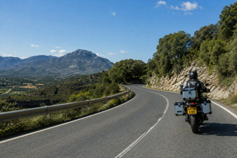
Ride south to north, from San Pedro to Ronda. Heading uphill gives you the full climbing experience on the tighter sections and keeps the Mediterranean views behind you rather than in front of you, reducing distraction on the technical parts. The road carries significant traffic: the A-397 is also the fastest route from the coast to Ronda for cars, coaches, and lorries. Weekends and public holidays bring volume that will cut your average speed considerably. Aim for a Tuesday or Wednesday morning, departing by 8am. There are two fixed average-speed cameras on the road and at least two mobile radar positions. Two fuel stations sit in San Pedro before the climb; the next reliable fuel is Ronda itself, 45 km away. Watch for occasional rockfall on the northern sections after heavy rain, and for fog at altitude in winter.
Scenic tip:
The A-397 is a curvy routing challenge: standard GPS will periodically suggest shortcuts back toward the coast. Set Scenic’s curvy routing mode before you leave San Pedro and it will hold you on the A-397 through the full 365 curves rather than defaulting to any valley-floor alternative that appears on the map. Save the route offline before you leave the coast. Mobile signal drops out through the upper mountain sections.
Ride this route:
Start (San Pedro de Alcantara): 36.4867, -4.9981
End (Ronda): 36.7462, -5.1641
San Pedro de Alcantara to Ronda on Scenic
Or get the whole route free here, with Scenic: https://scenicapp.space/route/nxZlXVMq
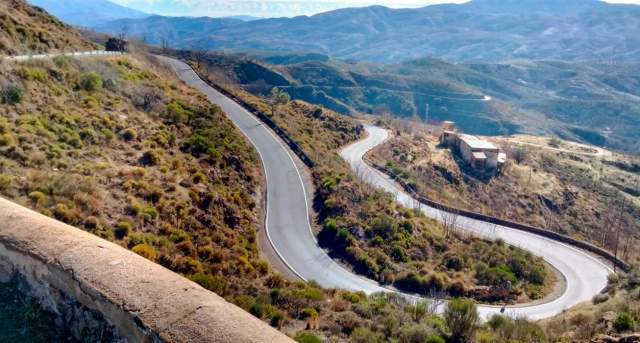
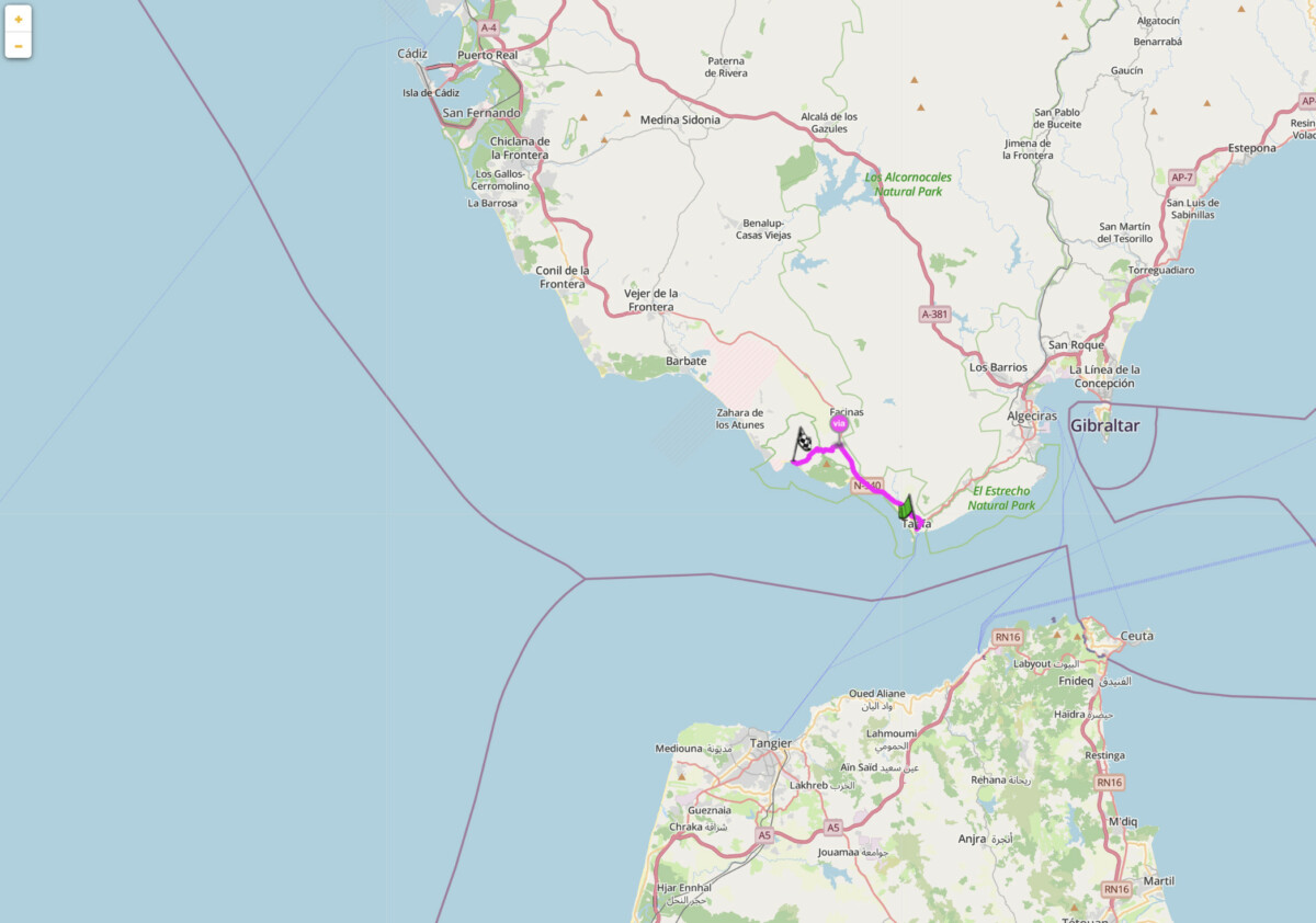
2. CA-9104 Puerto de las Palomas — Zahara de la Sierra to Grazalema, Cadiz
Distance: 17 km (Zahara de la Sierra to Grazalema)
Altitude: Summit: Puerto de las Palomas, 1,180 m
Best for: Short highlight ride, technical mountain pass, Sierra de Grazalema Natural Park
Best time: April to June, September to November
The Route:
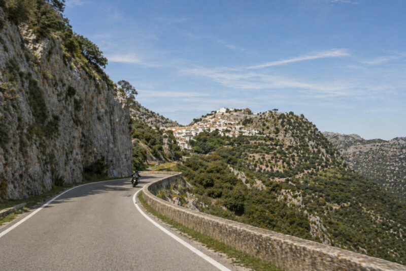
The CA-9104 is 17 km of concentrated mountain road connecting Zahara de la Sierra to Grazalema across the Puerto de las Palomas pass at 1,180 m. It is one of the most technically demanding short roads in Andalucia. The surface is consistently good but the road is narrow, the hairpins are tight, and visibility on several upper bends is limited. It sits inside the Sierra de Grazalema Natural Park, the wettest place in Spain at 2,200 mm of annual rainfall, which means the surface can be damp well after rain has stopped and drains slowly in shaded sections. The views from the pass look south over a limestone landscape of crags, cliffs, and the Zahara reservoir below. Grazalema is one of the finest of the pueblos blancos: a compact white village wedged between the peaks of Pico del Reloj and Pico de San Cristobal, with decent coffee and one of the better restaurants in the area.
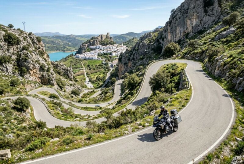
This is 17 km of the best road in the province of Cadiz. Plan the rest of the day around it. From Grazalema, the A-372 west to El Bosque and north to Ronda via the A-374 and A-376 adds another two hours of first-rate riding through the same natural park, combining into a full-day loop. From Zahara, the reservoir viewpoint on the approach road is worth a five-minute stop. Start from Zahara heading south: the road appears to vanish into the cliff above you before the hairpins materialise. Livestock and the occasional griffon vulture cross the road at the higher sections. The Puerto de las Palomas can close after heavy snowfall in December and January. Check local conditions before riding in winter.
Scenic tip:
The mirador at roughly the midpoint of the northern descent toward Grazalema is easily missed at speed. It sits on the outside of a right-hand bend and offers a clear view south down the full sweep of hairpins you have just climbed. Stop here. It is the best photograph point on the CA-9104, and most riders who want to find it again cannot locate it on a second visit without a waypoint saved.
Ride this route:
Start (Zahara de la Sierra): 36.8415, -5.3994
Summit (Puerto de las Palomas): 36.8290, -5.4375
End (Grazalema): 36.7633, -5.3721
Zahara de la Sierra to Grazalema on Scenic
Or get the whole route free here, with Scenic: https://scenicapp.space/route/GQYvqgTx
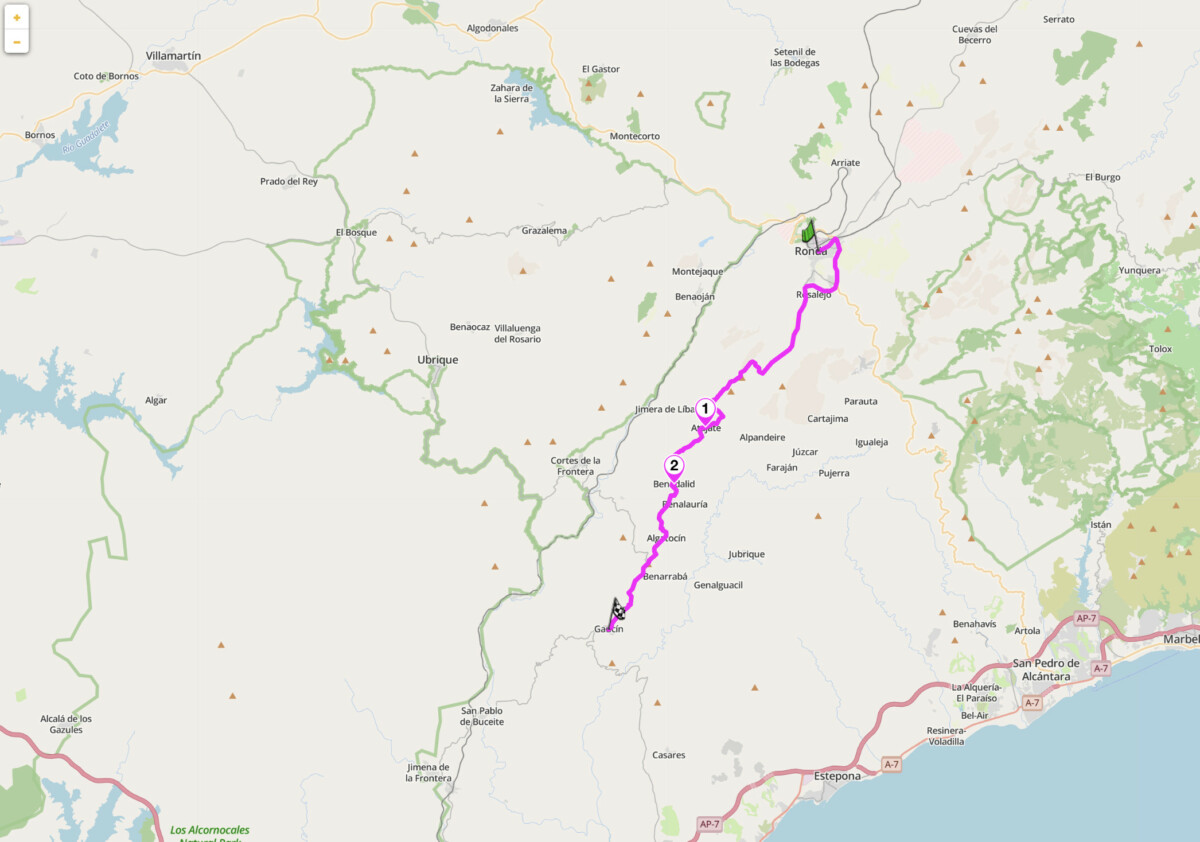
3. A-369 Ronda to Gaucin — Serrania de Ronda, Malaga
Distance: 42 km (Ronda to Gaucin)
Altitude: Gaucin at 656 m, with valley descents to 200 m
Best for: Flowing mountain touring, pueblos blancos, coast-to-mountains return leg
Best time: Year-round, best March to May and September to November
The Route:
The A-369 connects Ronda south to Gaucin and on to the coast at Manilva. It is the old English road: for two centuries British residents in Gibraltar took this route into the cooler air of the Serrania de Ronda to escape the summer heat, and the road still carries that quality of a route built for pleasure rather than speed. It follows the ridge line above the Genal valley, one of the least-visited and most forested valleys in Andalucia, passing through Moorish-origin villages including Atajate and Benadalid. The views east take in the layered white villages of the Genal, stacked on hillsides against a backdrop of cork oak and chestnut. To the south on clear days, Morocco is visible across the Strait. Gaucin itself, at 656 m on a bare rock outcrop above the valley, has a 10th-century Moorish castle with a 360-degree panorama taking in the coast, Gibraltar, and the full spread of the Serrania to the north.
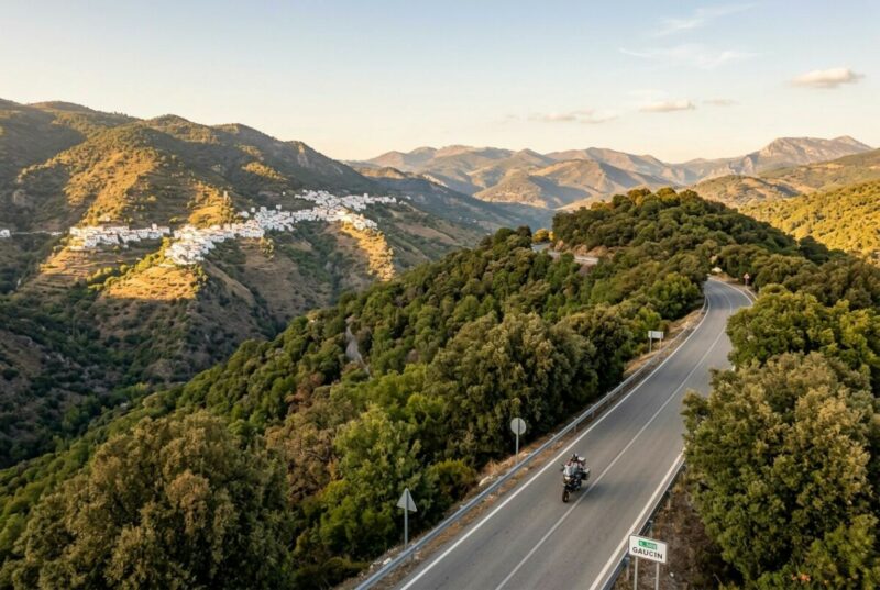
Ride north to south, from Ronda toward Gaucin. The road starts with a fast, flowing section out of Ronda before narrowing as it drops into the Genal valley. Surface quality varies: the sections through villages are tight and occasionally rough, the open ridge sections between villages are good. Fuel note: the petrol station at the Gaucin roundabout is the last reliable fuel before the coast, 30 km south. Fill up there. The A-369 combines naturally with the A-397 for a full-day circuit: ride the A-397 from San Pedro de Alcantara on the coast to Ronda in the morning, spend an hour in the town, then take the A-369 back south in the afternoon. Our route ends in Gaucin, but another 20km on is Casares, a scenic pueblo blanco with spectacular views and ruins of an Arab fortress. From there it’s 10 minutes back to the coast; you could go back to where you started, or head out to Gibraltar. This is one of Andalucia’s best natural day loops.
Scenic tip:
Between Benadalid and Algatocin, around km 35 from Ronda, a widening on the left shoulder gives a view east across the full length of the Genal valley. It is unmarked, has no formal parking, and disappears quickly. The valley stretches 25 km before you, the villages stacked from floor to ridge, the cork oaks covering the lower slopes. This is the kind of stop that the A-369 keeps offering and that most riders miss because there is no sign telling them to stop.
Ride this route:
Start (Ronda): 36.7462, -5.1641
End (Gaucin): 36.5156, -5.3201
Ronda to Gaucin on Scenic
Or get the whole route free here, with Scenic: https://scenicapp.space/route/GuRRlAJo
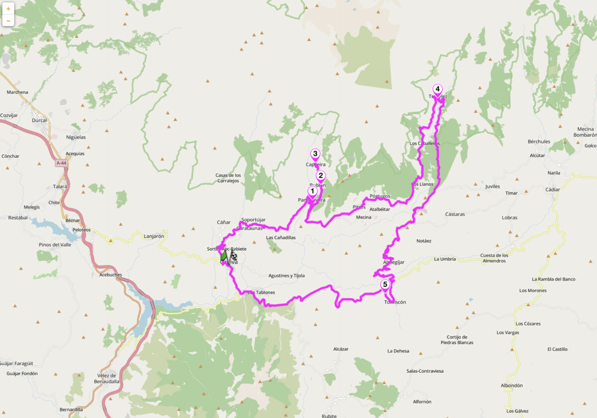
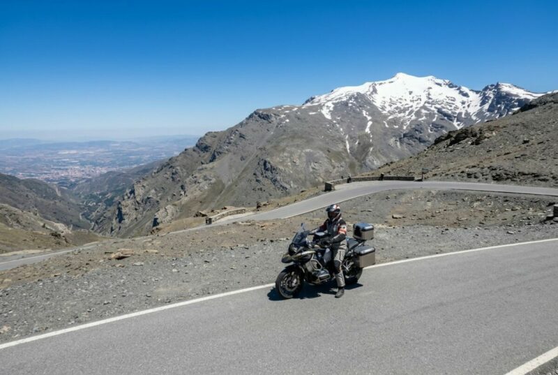
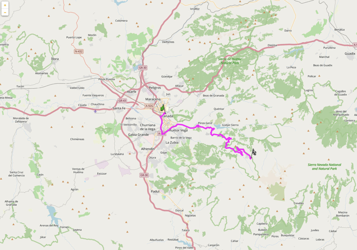
4. A-4132 Poqueira Gorge Loop — Orgiva to Trevelez, Granada
Distance: 86 km loop (Orgiva to Trevelez via Pampaneira, return via A-348)
Altitude: 450 m (Orgiva) to 1,486 m (Trevelez)
Best for: High-altitude village riding, Sierra Nevada southern slopes, Moorish landscape
Best time: April to June, September to October
The Route:
The A-4132 climbs from Orgiva, the administrative centre of the western Alpujarras, up the Poqueira Gorge to Trevelez at 1,486 m, the highest permanently inhabited village in Spain. The gorge road passes through Pampaneira, Bubion, and Capileira: three Moorish-origin villages stacked vertically on the gorge wall, each separated by a few hundred metres of altitude, their flat-roofed stone houses unchanged in form since the 16th century. Trevelez sits at the head of a separate valley to the east, reached from Capileira by a ridge road through pine forest. The village is known for its air-cured jamon serrano: the altitude and dry air make the conditions right, and the curing sheds are visible from the upper streets. The return loop on the A-348 back to Orgiva follows the lower Alpujarras shelf, a broader and faster road giving views south toward the coast.
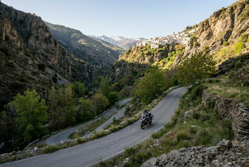
Ride the A-4132 uphill in the morning when the gorge is in shadow and the light is flat: the road is narrow, requires full attention, and glare into the bends on the descent can be a problem in afternoon sun. The villages receive tourist traffic from late morning, so the road through Pampaneira and Bubion can slow significantly after 10am in peak months. Fuel in Orgiva before climbing: there is no petrol station between Orgiva and Trevelez. The road above Capileira can carry snow from November to March. Check conditions before going above 1,200 m. The connecting road between Capileira and Trevelez involves a significant descent and climb.
Scenic tip:
Download offline maps for the Alpujarras before leaving Granada. The gorge roads between Pampaneira and Capileira have no reliable signal and some road turnings can be easy to miss.
Ride this route:
Start (Orgiva): 36.8973, -3.4207
Highlight (Capileira): 36.9736, -3.3537
End (Trevelez): 36.9992, -3.2671
Poqueira Gorge Loop on Scenic
Or get the whole route free here, with Scenic: https://scenicapp.space/route/hmyEBzXd
5. A-395 Sierra Nevada High Road — Granada to Mirador de la Hoya de la Mora
Distance: 44 km one way (Granada to Mirador de la Hoya de la Mora)
Altitude: 680 m (Granada) to 2,510 m (Mirador de la Hoya de la Mora)
Best for: Short highlight ride, highest paved road approach in Western Europe, snow-peak views
Best time: June to October
The Route:
The A-395 is the access road to the Sierra Nevada ski resort and continues to the Mirador de la Hoya de la Mora at 2,510 m, one of the highest public road destinations in Western Europe. From Granada the road climbs through the Pradollano ski area, functional rather than beautiful, but above the resort the landscape changes completely. Above 2,200 m the road enters open terrain of grey rock and residual snow patches. Mulhacen, at 3,478 m the highest peak on mainland Spain, is visible to the southwest. The Mirador sits at the end of the public road and looks across a valley to the permanent snowfields and the summit ridgeline. On a clear day, Granada can be visible and on exceptional days the coastline of Africa appears beyond the Sierra Nevada’s southern wall.
This is 45 minutes of the best road in the province. Plan the rest of the day around it. Ride early: the road sees significant hiker and tourist traffic from late morning, and the single carriageway above the ski resort means encounters with descending cars in blind bends. The summit plateau is exposed and cold even in August: bring a layer. The road beyond the Mirador is restricted to authorised vehicles only. Fill up in Granada; the only fuel above the city is at the ski resort base, which is often closed out of ski season. Temperature at the summit can be 15 to 20 degrees cooler than Granada city. The ski area section of the A-395 closes when snow requires it, typically November to May.
Scenic tip:
Come back down via the same road in the late afternoon. The low sun catches the snowfields above, and the city of Granada is lit from the west below you. The descent in that light is a different road from the morning climb.
Ride this route:
Start (Granada): 37.1773, -3.5986
End (Mirador de la Hoya de la Mora): 37.0952, -3.3836
Sierra Nevada High Road on Scenic
Or get the whole route free here, with Scenic: https://scenicapp.space/route/sFSMRAYb
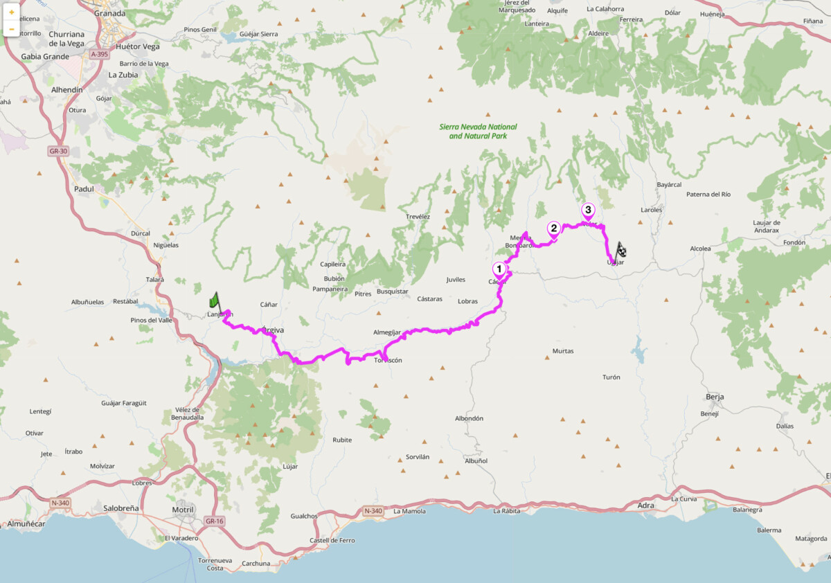
6. A-348 Las Alpujarras Traverse — Lanjaron to Ugijar, Granada
Distance: 73 km (Lanjaron to Ugijar)
Best for: An Alpujarras traverse, village-to-village touring, east Alpujarras exploration
Best time: April to June, September to November
The Route:
The A-348 is the spine road of the Alpujarras, running along the southern shelf of the Sierra Nevada from Lanjaron in the west to Ugijar in the east. Use Scenic to explore the surrounding villages and make this a full day’s ride. The road is rarely straight, crosses four river valleys, and the terrain shifts from lush chestnut and poplar woodland in the west to increasingly arid ochre hillsides as you move east toward Almeria province. The western section from Lanjaron to Orgiva is the approach road and the broadest part. From Orgiva east the A-348 becomes slower and more characterful: it passes through Cadijar, Yegen, and Valor. Yegen is the village where the British writer Gerald Brenan lived in the 1920s and received Virginia Woolf and Lytton Strachey as visitors. The eastern end toward Ugijar enters a distinctly different Alpujarras: fewer tourists, drier air, older villages.
Ride west to east, from Lanjaron toward Ugijar. The morning light is better facing east in the early hours, and riding with the sun behind you keeps glare off the road surface. The A-348 is not a technical road in the same sense as the A-4132, but it is relentlessly engaging: frequent village passes at reduced speed, narrow stone bridges over river gorges, and sections of road that still show Moorish irrigation channel engineering on the uphill side. Fuel: Orgiva (reliable), Cadijar (reliable). Between Cadijar and Ugijar the road becomes more remote, 40 km with only small villages and no guaranteed fuel. Plan accordingly.
Scenic tip:
A small detour away, the stretch between Mecina Bombarron and Yegen passes a viewpoint that looks north to the full southern face of the Sierra Nevada. In late spring the upper slopes still carry snow and the lower terraces are green. There is no marker for it: a widening of the road on the right around km 78 east of Lanjaron. This is Andalucia doing something no brochure has photographed.
Ride this route:
Start (Lanjaron): 36.9211, -3.4791
End (Ugijar): 36.9699, -3.0466
Las Alpujarras Traverse on Scenic
Or get the whole route free here, with Scenic: https://scenicapp.space/route/EoxkUjxG
7. A-316 Olive Oil Route — Andujar to Ubeda, Jaen
Distance: 100 km (Andujar to Ubeda via A-311 and A-316)
Best for: Open touring, UNESCO olive landscape, flowing bends, Renaissance towns
Best time: October to April
The Route:
Jaen province produces more olive oil than any country on earth. The A-311 north from Andujar and then east along the A-316 to Ubeda crosses the heart of this landscape: 100 km of flowing road through an unbroken canopy of silver-green olive groves extending to every horizon. This is not a technical road. It is a decompression road. After the technical mountain routes of the western sierras, the A-316 gives you long, clean sightlines, consistent bends, and a surface that rewards pace rather than line. The route ends at Ubeda, a Renaissance city with a UNESCO-listed old town built on olive oil wealth in the 16th century. Baeza, 10 km west on the same road, is its smaller, quieter twin: also UNESCO, also built on oil, and worth the detour. The A-311 out of Andujar through the Sierra Morena foothills has particularly good early bends before opening into the valley.
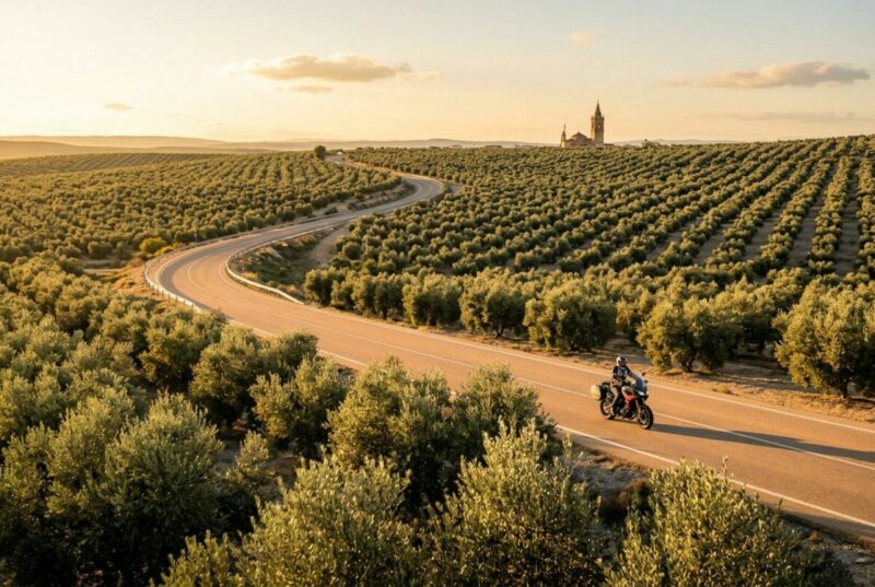
Ride this in autumn when the harvest is underway: the olive groves have colour, the road is cool, and the light across the valley is exceptional. From October to November you will pass tractors and olive harvesting equipment on the A-311 approach. They are slow but pull over readily. The Sierra Magina mountains will appear in the distance on your right to the south as you leave Baeza eastwards. Ubeda has a ZTL restricted traffic zone in the old centre: park on the perimeter. Fuel in Andujar and Ubeda.
Scenic tip:
Use Scenic’s Round Trip feature from Ubeda to build a hub-and-spoke loop through the Cazorla Natural Park to the east. The A-319 into the Sierra de Cazorla adds another 60 km of mountain road, with the Guadalquivir river appearing in a narrow gorge at its deepest point. The Cazorla approach roads are among the most underrated in Andalucia and almost never appear in touring guides aimed at visitors based on the coast.
Ride this route:
Start (Andujar): 38.0405, -4.0498
End (Ubeda): 38.0128, -3.3702
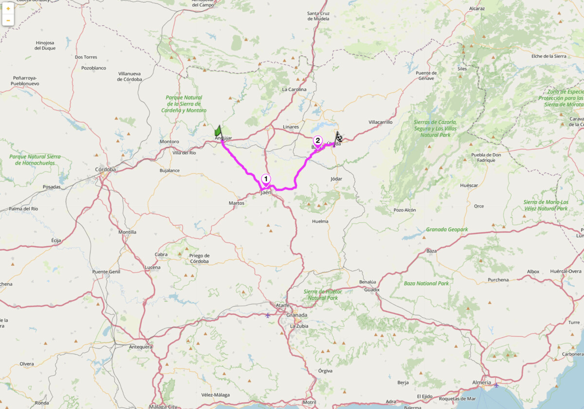
Andujar to Ubeda on Scenic
Or get the whole route free here, with Scenic: https://scenicapp.space/route/ZcsAsypr
8. A-461: Aracena to Zufre via Minas de Riotinto
Distance: 92 km loop (Aracena to Minas de Riotinto via 479, to Zufre via A-461, return via N-433)
Best for: Remote riding, Rio Tinto mining landscape, underrated western Andalucia
Best time: Year-round, best March to May and September to November
The Route
The Sierra de Aracena is the part of Andalucia that almost no touring riders reach as most never turn off the N-433 heading from Sevilla to Portugal. That is precisely why it is worth riding. At Minas de Riotinto the landscape becomes unmistakable. The open-pit Corta Atalaya is one of the largest in Europe and the Rio Tinto itself runs the colour of blood from dissolved iron and heavy metal sulphides. The road between Campofrio and Zufre is the kind of narrow, lightly trafficked, consistently good tarmac you spend your trip looking for. Tight bends through cork oak and chestnut forest, no major towns for long stretches.

Zufre sits on a rocky outcrop above the reservoir, a whitewashed village of around 1,000 people with a 16th-century church, an old town hall, and a viewpoint at the Paseo de los Alcaldes that looks out over the dam. This loop is best combined with a night in Aracena. The town is built around a 13th-century Moorish-era castle and the Gruta de las Maravillas, a 2,130-metre cave system opened to the public in 1913 that runs directly under the castle hill.
Scenic tip
Fuel in Aracena before departing. Petrol stations south of Higuera de la Sierra are sparse, and the A-461 has none between Zufre and Minas de Riotinto. Use Scenic’s petrol station search the night before to plan your stops, and download the Huelva province offline map. Mobile signal drops in the dehesa sections south of Zufre, and the Aracena-Riotinto loop is exactly the kind of remote ride where offline navigation earns its place.
Ride this route
Start/End: Aracena, Huelva — 37.8917° N, 6.5586° W
Zufre: 37.8333° N, 6.3500° W
Minas de Riotinto: 37.6925° N, 6.5894° W
Campofrío (return loop): 37.7625° N, 6.5564° W
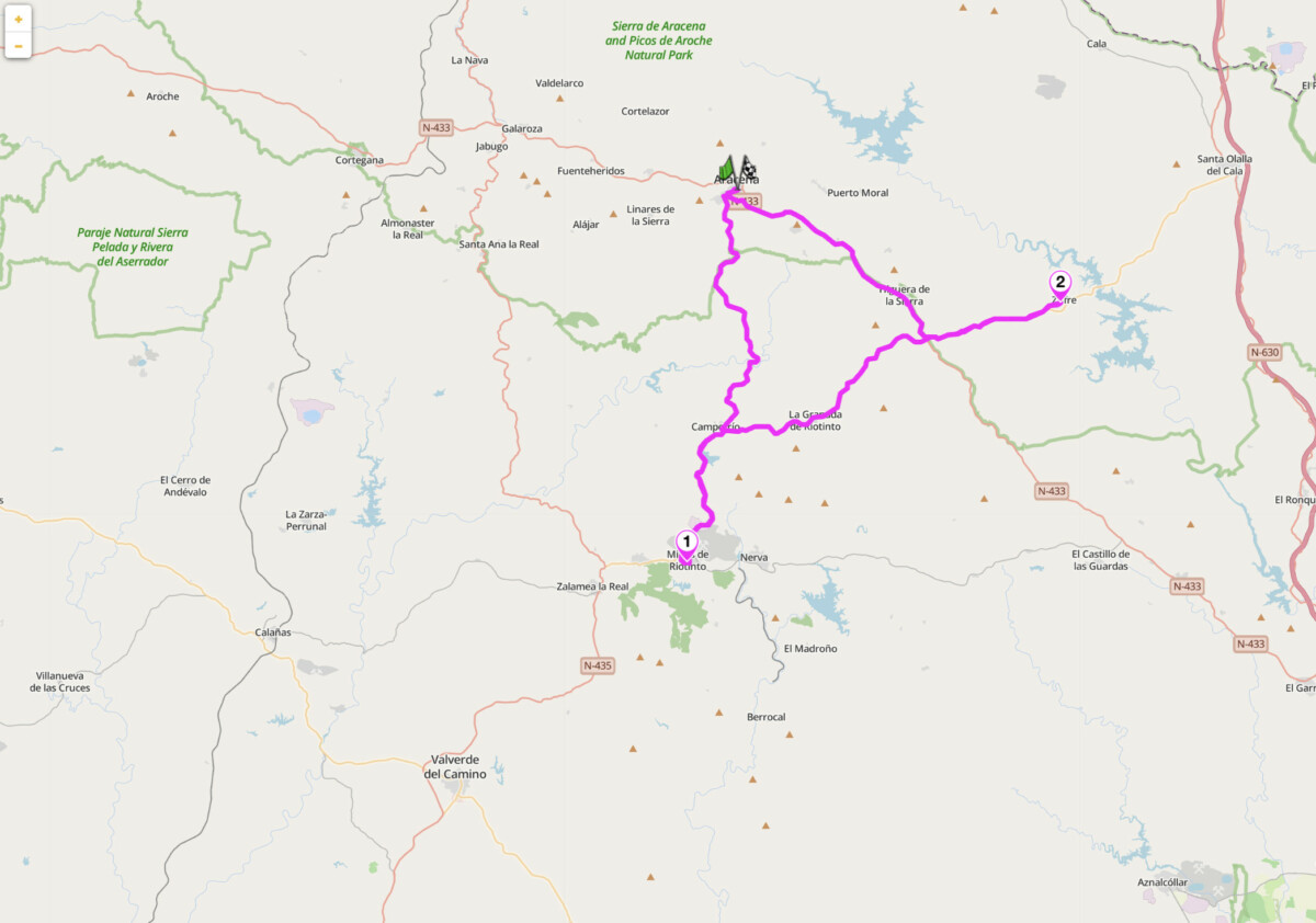
Aracena to Zufre via Minas de Riotinto on Scenic
Or get the whole route free here, with Scenic: https://scenicapp.space/route/RISSUhSo
9. N-340 and CA-8202 Tarifa to Bolonia — Costa de la Luz, Cadiz
Distance: 23 km (Tarifa to Bolonia)
Best for: Coastal touring, Africa visible, short highlight ride, Roman ruins at Baelo Claudia
Best time: September to May
The Route:
Tarifa is the southernmost point of mainland Europe. The N-340 northwest from Tarifa runs along the Atlantic coast of the Costa de la Luz toward Bolonia, with the Strait of Gibraltar and the Moroccan coast visible to the south for most of the route. At its narrowest point the Strait is 14 km wide, and on clear days the Rif mountains show individual ridgelines. In Bolonia the Roman ruins of Baelo Claudia, a fully excavated 1st-century BC fishing town, sit directly behind the beach: a theatre, basilica, fish-salting tanks, and a forum, all intact to wall height. No admission charge, almost always uncrowded. The dune system behind the beach is one of the largest in Andalucia.
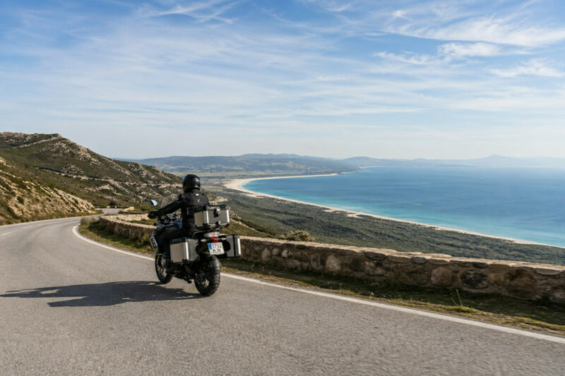
The levante wind is a factor on this stretch. Tarifa is the windiest city in Spain by average wind speed, and when the levante is blowing it comes directly off Africa at sustained 60 to 80 km/h. It is a crosswind on the N-340 and will move a loaded bike. Check wind forecasts before riding this section in July and August when the levante is most consistent. The road is short but earns its place: there is nowhere else in Europe where you ride with Africa in front of you and the southernmost point of the continent at your back. Combine it with the mountain roads inland via the A-2228 toward Alcala de los Gazules for a full day in Cadiz province.
Scenic tip:
A small detour to the Mirador del Estrecho 8km east of Tarifa is an obvious stop. The less obvious one is the pullover at the CA-8202 junction for Bolonia, looking back southeast toward Tarifa. At low tide the sandbar extending from the town is exposed and the strait narrows visually to almost nothing. Morocco at this point is closer than Malaga. Give it five minutes.
Ride this route:
Start (Tarifa): 36.0143, -5.6044
End (Bolonia): 36.0786, -5.7720
Tarifa to Bolonia on Scenic
Or get the whole route free here, with Scenic: https://scenicapp.space/route/UOwckuCA
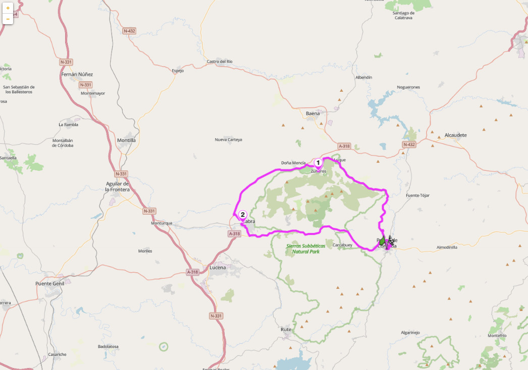
10. A-339 Sierras Subbeticas Loop — Priego de Cordoba to Zuheros, Cordoba
Distance: 75 km loop (Priego de Cordoba to Zuheros, return via Cabra)
Best for: Coastal touring, Africa visible, short highlight ride, Roman ruins at Baelo Claudia
Best time: September to May
The Sierras Subbéticas of Córdoba province are almost entirely absent from standard touring itineraries. They should not be. The park is a UNESCO Global Geopark, declared for its limestone karst geology: gorges, cave systems, dolinas, and the highest peak in Córdoba province at La Tiñosa (1,570 m). Priego de Córdoba is arguably the finest Baroque town in Andalucia, with a series of 18th-century churches and a path running along the edge of a cliff above the valley below. Zuheros is a smaller village in a similar position, built at the base of a limestone cliff with a Moorish castle above and the Cueva de los Murciélagos cave system in the hills outside town.
The roads through it are quiet, technical in places, and consistently good, combining sprawling olive groves and rolling hills. Arrival into Zuheros is a highlight of the loop; nestled whitewashed houses are exposed after a winding road. Complete the loop by heading east on the A-339 through the heart of the park where the road descends into Priego de Córdoba, a town worth exploring for at least one hour. Reliable fuel stops are in Cabra and Priego. The combination of Priego, Zuheros, and the gorge road is underrated in every language and on every map.
Scenic tip
The Bailón canyon viewpoint above Zuheros, on the CV-247 toward the Cueva de los Murciélagos, gives a full view across the Bailón gorge to the Subbéticas plateau. Best at around 4pm when the afternoon light hits the limestone cliffs directly. Load Scenic’s offline maps for Córdoba province before leaving the city. The smaller connecting roads between Zuheros, Doña Mencía, and Luque do not always appear correctly in standard navigation, and the gorge sections have no signal.
Ride this route
Cabra: 37.4744° N, 4.4421° W
Santa Rita visitor centre (Puerto del Mojón): 37.4623° N, 4.3524° W
Priego de Córdoba: 37.4397° N, 4.1966° W
Zuheros: 37.5475° N, 4.3169° W
Bailón canyon viewpoint: 37.5342° N, 4.3113° W
Sierras Subbeticas Loop
Or get the whole route free here, with Scenic: https://scenicapp.space/route/ZFEAezLz
Planning Your Ride
Andalucia has the most forgiving riding season in mainland Europe. The western sierras (Cadiz, Malaga, Huelva) are rideable year-round, with winter temperatures rarely dropping below 10 degrees Celsius at altitude and occasionally reaching 20 degrees on the coast in January. The high-altitude routes change the calculation: the Sierra Nevada road closes above the ski resort from roughly November to May, and the Puerto de las Palomas (CA-9104) can close after snowfall in December and January. The Alpujarras traverse stays open year-round but the connecting passes above Capileira are snow-affected from November. The best overall seasons are April to June and mid-September to November. Summer in Jaen and Cordoba provinces can reach 42 degrees on valley roads. Plan early starts and build in shade breaks if riding interior routes in July and August.
Spanish motorcycle law requires dipped headlights at all times, including in towns. Since 2024, CE-approved gloves are a legal requirement for all riders. The blood alcohol limit is 0.5 g/l for experienced riders and 0.3 g/l for those who have held a licence less than two years. Radar detectors are illegal to carry and use in Spain, including apps on a mounted smartphone. The speed limit on secondary mountain roads defaults to 90 km/h without a marked sign, but the actual advisory speeds on the technical routes in this guide are significantly lower. Andalucia’s secondary roads are not toll roads. Motorway tolls on privately operated autopistas are charged per km; motorcycles pay in the lightest vehicle category.
Where to base yourself
Ronda is the single best base for western Andalucia. It sits at the junction of the A-397, A-369, and access roads to the Sierra de Grazalema, putting routes 1, 2, and 3 within 30 minutes of town. Good accommodation at all price points and several motorcycle-friendly hotels with secure parking.
Granada gives access to the Sierra Nevada, the Alpujarras, and the Sierras Subbeticas. Routes 4, 5, and 6 are all within 45 minutes of the city. The Alhambra is 15 minutes from any hotel: book tickets at least three weeks in advance.
Aracena is the base for the Sierra Morena and Huelva routes. It is quiet, low-cost, and largely unknown to international tourists. The food here is better than anywhere else on this list.
Cordoba covers the Sierras Subbeticas and the Jaen routes. The Mezquita is worth your time. Riding in the old city centre involves narrow streets and a partial ZTL zone: leave the bike at the hotel and walk.
Frequently asked questions
When is the best time to ride in Andalucia? April to June and mid-September to November. Spring gives green landscapes and open passes. Autumn gives cooler temperatures and the olive harvest in Jaen. Winter on the coast and lower sierras is mild and quiet. Summer is viable on coastal routes and the Alpujarras but can be severe in the interior.
Is the A-397 open year-round? Yes. It is a main road between the coast and Ronda and stays open through winter. Ice is rare but possible above 500 m in January. Check conditions after overnight frost.
When does the Sierra Nevada road (A-395) close? The public road to the Mirador de la Hoya de la Mora closes from the ski resort car park level in November and reopens in May or June depending on snowfall. The lower sections through the resort stay open for ski access.
Do I need a vignette for Spanish roads? No. Spain uses a ticket-based toll system on privately operated autopistas. No vignette is required. All secondary roads used in this guide are toll-free.
Is lane splitting legal in Spain? Lane splitting in moving traffic remains illegal. Filtering to the front of stationary traffic in a traffic jam is permitted, at a maximum of 30 km/h.
Are there ZTL restrictions in Andalucian towns? Yes, in the historic centres of Ronda, Granada, Cordoba, and Ubeda. In most cases hotel guests can obtain a temporary permit. Confirm with your accommodation before arriving. Arrival and departure during restricted hours require the hotel to register your plate with the local authority.
Andalucia has more good roads than any single trip can cover. Pick your region, plan your loop, and go.
Scenic Premium gives you turn-by-turn motorcycle navigation with full offline maps for every route in this guide, curvy routing mode to keep you on the interesting roads, and automatic waypoint alerts for the junctions that matter. It is built for how riders actually use navigation on the road, not how car drivers do. Download Scenic on iOS or Android and plan your Andalucia loop before you leave home.
If you go, tag us and use the hashtag #ridewithscenic for your chance to win a free Scenic t-shirt.
You’ve made it to the end of the article! At Scenic we like to reward people who plan their trips properly. If you’re not already a premium member, use this code to get 15% off your first year of Scenic Premium: Premium15


May 22nd 2026
Brilliant.! Just come down to our house in Murcia for 12 days of riding with a friend. This hit my mailbox last night. Perfect timing and I couldn’t agree more with the first introductory paragraph. There is nowhere quite like Spain for motorcycling.
Thanks Hamish! We’d love to see your trip if you’ve got any photos? We’ll share them on social if so!
Sería todo un detalle que también lo publicarais en otros idiomas, bien lo hacéis en español cuando envías emails.
Post data:
Dejaros de chorradas matemáticas para demostrar que es un humano quien escribe. Por cierto, fui suscriptor de vuestro programa hasta que dejasteis de dar servicio con el cuento de la cartografía dejando de funcionar vuestra App con CarPlay y me jodisteis porque tuve que comprar un soporte para el móvil más una funda impermeable. Las consecuencias fueron más que evidentes, no renové la suscripción.