
4.42 Importing from Kurviger almost perfect

Quote from Old Man Emu on 22.07.2026, 21:25Guido, 4.42 is looking good.
As you know I import a lot of routes from Kurviger and up to know it has changed Kurviger Via points (whichare stops) to Scenic Vias and dropped the name and Kurviger Shaping Points (vias) to Scenic Stops.
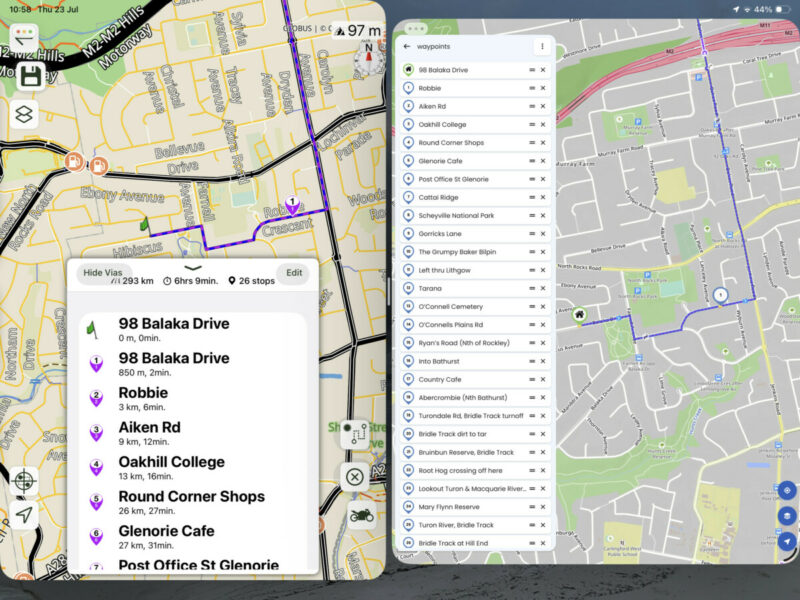
4.42 has fixed that but I have an offset problem at the start of the route. See attached image of the two routes;
In Kurviger I start my route a few hundred meters up the road 98 Balaka as home and stop 1 is Robbie
Sending it to Scenic it starts my route at 98 Balaka as Home but pushes my Kurvider Home to stop one and so one so pushing all my stops one ahead with the wrong names. I hope that is clear.
Keep up the brilliant work Guido.
Guido, 4.42 is looking good.
As you know I import a lot of routes from Kurviger and up to know it has changed Kurviger Via points (whichare stops) to Scenic Vias and dropped the name and Kurviger Shaping Points (vias) to Scenic Stops.
4.42 has fixed that but I have an offset problem at the start of the route. See attached image of the two routes;
In Kurviger I start my route a few hundred meters up the road 98 Balaka as home and stop 1 is Robbie
Sending it to Scenic it starts my route at 98 Balaka as Home but pushes my Kurvider Home to stop one and so one so pushing all my stops one ahead with the wrong names. I hope that is clear.
Keep up the brilliant work Guido.

Quote from Guido on 22.07.2026, 22:00It’s pushing the stop NAMES forward if I understand correctly, right? So I assume, the name of your destination as it is in Kurviger is falling off the list in Scenic too, correct?
It’s pushing the stop NAMES forward if I understand correctly, right? So I assume, the name of your destination as it is in Kurviger is falling off the list in Scenic too, correct?
Quote from Old Man Emu on 22.07.2026, 22:03Actually the end stop is retained and the second last is dropped
Actually the end stop is retained and the second last is dropped
Quote from Guido on 22.07.2026, 22:08Ok. Ok will investigate.
Ok. Ok will investigate.
Quote from Guido on 23.07.2026, 10:16@old-man-emu could you send me this GPX file from Kurviger? Use the 'email me' button at the bottom of https://scenic.app/help
It's because I tried with a test route with a few stops in Kurviger, and with that one I don't have this problem.
@old-man-emu could you send me this GPX file from Kurviger? Use the 'email me' button at the bottom of https://scenic.app/help
It's because I tried with a test route with a few stops in Kurviger, and with that one I don't have this problem.

Quote from MartinW on 23.07.2026, 11:55Quote from Old Man Emu on 22.07.2026, 21:25As you know I import a lot of routes from Kurviger ...
Interesting! Are you using Kurviger for planning and Scenic for navigating?
Quote from Old Man Emu on 22.07.2026, 21:25As you know I import a lot of routes from Kurviger ...
Interesting! Are you using Kurviger for planning and Scenic for navigating?
Quote from Old Man Emu on 23.07.2026, 17:20Quote from Guido on 23.07.2026, 10:16@old-man-emu could you send me this GPX file from Kurviger? Use the 'email me' button at the bottom of https://scenic.app/help
It's because I tried with a test route with a few stops in Kurviger, and with that one I don't have this problem.Sent
Quote from Guido on 23.07.2026, 10:16@old-man-emu could you send me this GPX file from Kurviger? Use the 'email me' button at the bottom of https://scenic.app/help
It's because I tried with a test route with a few stops in Kurviger, and with that one I don't have this problem.
Sent
Quote from Old Man Emu on 23.07.2026, 17:31I tried a short route as well as the same issue. Screenshots here
[caption id="attachment_10841" align="alignnone" width="800"]
Screenshot[/caption]
[caption id="attachment_10842" align="alignnone" width="800"]
Screenshot[/caption]
I tried a short route as well as the same issue. Screenshots here
[caption id="attachment_10841" align="alignnone" width="800"] Screenshot[/caption]
[caption id="attachment_10842" align="alignnone" width="800"] Screenshot[/caption]
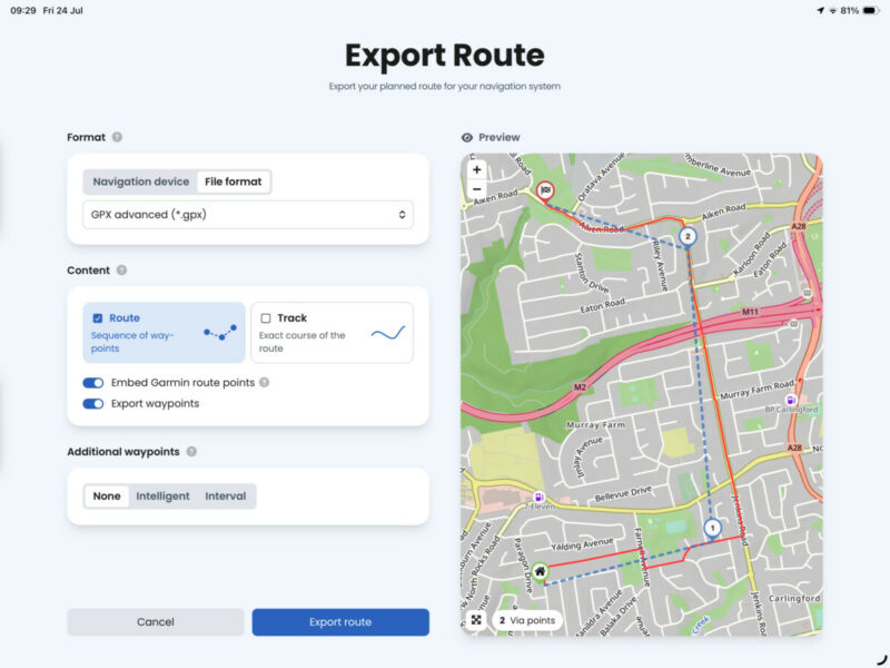
Quote from Guido on 23.07.2026, 17:43I took a look at the file. It's because you are exporting as GPX advanced. If you export as the standard GPX is will work.
I took a look at the file. It's because you are exporting as GPX advanced. If you export as the standard GPX is will work.
Quote from Old Man Emu on 23.07.2026, 17:44Quote from MartinW on 23.07.2026, 11:55Quote from Old Man Emu on 22.07.2026, 21:25As you know I import a lot of routes from Kurviger ...
Interesting! Are you using Kurviger for planning and Scenic for navigating?
Hi Martin, my first bike navigation app was Kurviger and I have over 200 rides and 400 favourite places in there.
I used a Garmin for navigation to avoid heat stress on the iPhone. I started to look at Scenic and I liked a lot of things so I am transitioning over.
for me planning in K is a little better but navigation and control in Scenic is much, much better:
- In K you can hop thru the waypoints to see exactly where they are and the distance before and after
- For me K shows dirt sections better and gives an area chart of dirt v sealed
- K has “snap waypoints to nearest road”. I think Scenic is getting this
- K has a review for potential issues like ‘waypoint to close to intersection”. “Water crossing”
scenic also allows me to search for rides in different folders. K cannot do that and we’ve been asking for 4 years!
Quote from MartinW on 23.07.2026, 11:55Quote from Old Man Emu on 22.07.2026, 21:25As you know I import a lot of routes from Kurviger ...
Interesting! Are you using Kurviger for planning and Scenic for navigating?
Hi Martin, my first bike navigation app was Kurviger and I have over 200 rides and 400 favourite places in there.
I used a Garmin for navigation to avoid heat stress on the iPhone. I started to look at Scenic and I liked a lot of things so I am transitioning over.
for me planning in K is a little better but navigation and control in Scenic is much, much better:
- In K you can hop thru the waypoints to see exactly where they are and the distance before and after
- For me K shows dirt sections better and gives an area chart of dirt v sealed
- K has “snap waypoints to nearest road”. I think Scenic is getting this
- K has a review for potential issues like ‘waypoint to close to intersection”. “Water crossing”
scenic also allows me to search for rides in different folders. K cannot do that and we’ve been asking for 4 years!
Quote from Old Man Emu on 23.07.2026, 17:50Quote from Guido on 23.07.2026, 17:43I took a look at the file. It's because you are exporting as GPX advanced. If you export as the standard GPX is will work.
Yes, you are correct. Thanks for your exceptional service.
I use GPX Advanced as I also use a Garmin and it works better.
I’m happy to know this and live with it but if it can be amended it might help other users and reduce support calls.
thanks again. Now I would like the startup sound of scenic to be my own exhaust note 🎵🎶🎼🏍️⚙️
Quote from Guido on 23.07.2026, 17:43I took a look at the file. It's because you are exporting as GPX advanced. If you export as the standard GPX is will work.
Yes, you are correct. Thanks for your exceptional service.
I use GPX Advanced as I also use a Garmin and it works better.
I’m happy to know this and live with it but if it can be amended it might help other users and reduce support calls.
thanks again. Now I would like the startup sound of scenic to be my own exhaust note 🎵🎶🎼🏍️⚙️
Quote from MartinW on 24.07.2026, 04:25Thanks for sharing your thoughts, @old-man-emu!
It looks like we have a similar background and approach. I also started with Garmin but switched to a smartphone a few years back. I tried several apps; Kurviger is my favourite at the moment for planning and navigation. Although I'm an Apple user at heart, I use an Android phone as a navigation device - that's why Scenic wasn't on my list so far.
Currently, I'm taking a deep dive into S to figure out if it fits my needs even better than K. The customisable map is definitely outstanding, followed by the TomTom traffic info, which seems to be real-time, and the offline capabilities. You mentioned some of the K's excellent features - but what are the benefits of S over K from your point of view?
Regarding data migration, I do have an archive with a lot of GPX tracks; importing them into S and saving as "blue track line" only works smoothly.
I only use routes for planning, not for the archive, so I only have a few there, and I can transfer those just as easily. "GPX" as a K export format definitely works, and with "GPX Advanced," it's the additional "Garmin route points" that cause the problem you mentioned, but I don't need those.
Migrating POI lists (in terms of having the same category, like restaurants) works well, as I can assign a proper category/icon during import into S. My main concerns are my large list of locations, which are organised by country, where each list contains locations with different categories. I'm still looking for a good way to automate icon assignment so I don't have to adjust them all manually. Is there anything like that?
Planning with S is basically the same as with K; there are vias (SPs) and stops (VPs). I'm not quite happy with S's routing profiles so far - "standard" uses too many main roads (even with "adventurous"), and using "curvy" adds a lot of vias. Not ideal compared with K, but maybe I need some more practice with S to get used to it 🙂
Thanks for sharing your thoughts, @old-man-emu!
It looks like we have a similar background and approach. I also started with Garmin but switched to a smartphone a few years back. I tried several apps; Kurviger is my favourite at the moment for planning and navigation. Although I'm an Apple user at heart, I use an Android phone as a navigation device - that's why Scenic wasn't on my list so far.
Currently, I'm taking a deep dive into S to figure out if it fits my needs even better than K. The customisable map is definitely outstanding, followed by the TomTom traffic info, which seems to be real-time, and the offline capabilities. You mentioned some of the K's excellent features - but what are the benefits of S over K from your point of view?
Regarding data migration, I do have an archive with a lot of GPX tracks; importing them into S and saving as "blue track line" only works smoothly.
I only use routes for planning, not for the archive, so I only have a few there, and I can transfer those just as easily. "GPX" as a K export format definitely works, and with "GPX Advanced," it's the additional "Garmin route points" that cause the problem you mentioned, but I don't need those.
Migrating POI lists (in terms of having the same category, like restaurants) works well, as I can assign a proper category/icon during import into S. My main concerns are my large list of locations, which are organised by country, where each list contains locations with different categories. I'm still looking for a good way to automate icon assignment so I don't have to adjust them all manually. Is there anything like that?
Planning with S is basically the same as with K; there are vias (SPs) and stops (VPs). I'm not quite happy with S's routing profiles so far - "standard" uses too many main roads (even with "adventurous"), and using "curvy" adds a lot of vias. Not ideal compared with K, but maybe I need some more practice with S to get used to it 🙂
Quote from Old Man Emu on 25.07.2026, 01:35Martin, I always had issues navigating with Kurviger so I never did. I exported to Garmin.
Scenics navigation is the best, perfect layout and control. I also like how the scenic map is infinitely zoomable, Kurviger jumps in steps.
a few friends used Scenic so that made it easy to share rides.
I use the Scenic Apple Shortcuts app lot - top left and middle “My Scenic Shortcuts”. The first one gets my GPS location and send it to my travelling buddies if I get into trouble or I’ve just stopped to take photos.
Scenic Apple Shortcutsa lot
[caption id="attachment_10845" align="alignnone" width="695"]
Screenshot[/caption]
I can’t recall if K lets you have multiple vehicles. S is good for that and for statistics per vehicle.
i plan a lot on PC Windows so K is required there at the moment. If Scenic had a windows planner I would probably drop my paid subscription to K.
Scenics customisable maps are great.
Martin, I always had issues navigating with Kurviger so I never did. I exported to Garmin.
Scenics navigation is the best, perfect layout and control. I also like how the scenic map is infinitely zoomable, Kurviger jumps in steps.
a few friends used Scenic so that made it easy to share rides.
I use the Scenic Apple Shortcuts app lot - top left and middle “My Scenic Shortcuts”. The first one gets my GPS location and send it to my travelling buddies if I get into trouble or I’ve just stopped to take photos.
Scenic Apple Shortcutsa lot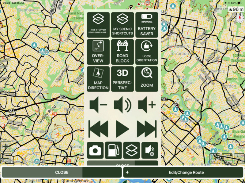
[caption id="attachment_10845" align="alignnone" width="695"] Screenshot[/caption]
I can’t recall if K lets you have multiple vehicles. S is good for that and for statistics per vehicle.
i plan a lot on PC Windows so K is required there at the moment. If Scenic had a windows planner I would probably drop my paid subscription to K.
Scenics customisable maps are great.
Quote from MartinW on 26.07.2026, 04:19Interesting insights!
My focus is on the core features for planning and navigation and how I can use them to map out my workflow as best possible.
I’ve been playing around a bit to get a feel for the differences between K and S when it comes to planning; now I want to take it more seriously: I’m going to plan a multi-day trip from scratch in both K and S in parallel, and I’ll navigate the routes using both K and S.
I’m curious to see how it turns out!
Interesting insights!
My focus is on the core features for planning and navigation and how I can use them to map out my workflow as best possible.
I’ve been playing around a bit to get a feel for the differences between K and S when it comes to planning; now I want to take it more seriously: I’m going to plan a multi-day trip from scratch in both K and S in parallel, and I’ll navigate the routes using both K and S.
I’m curious to see how it turns out!

Quote from Dae on 26.07.2026, 13:51The only real major thing stopping me from planning in Scenic is the lack of running total for mileage/time.
Without it I find planning fuel/coffee/lunch stops almost impossible, as you can’t tell where you’ll be and approximately when. I have medical requirements, so have to be able to figure out where I’m going to be when I’m due to eat, so I can ensure it’s not somewhere where there’s nothing around.
MRA is brilliant for that, and being available in a web browser (but not without its issues), but it’s a pain having to export, import into Scenic and then make the Scenic route match the planned MRA route. I’d really like to get everything done in Scenic but that’s unlikely to be any time soon.
Can Kurviger offer that same feature in planning?
The only real major thing stopping me from planning in Scenic is the lack of running total for mileage/time.
Without it I find planning fuel/coffee/lunch stops almost impossible, as you can’t tell where you’ll be and approximately when. I have medical requirements, so have to be able to figure out where I’m going to be when I’m due to eat, so I can ensure it’s not somewhere where there’s nothing around.
MRA is brilliant for that, and being available in a web browser (but not without its issues), but it’s a pain having to export, import into Scenic and then make the Scenic route match the planned MRA route. I’d really like to get everything done in Scenic but that’s unlikely to be any time soon.
Can Kurviger offer that same feature in planning?
Quote from Old Man Emu on 26.07.2026, 16:32I don’t want to go on a sales drive for Kurviger on this site. I’m committed to Scenic as Guido provides the best service and support of all
These Points have been raised and I know he is considering.
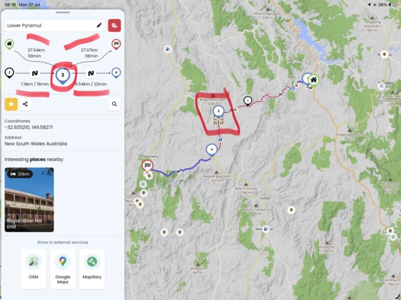
Kurviger does this very well and has two ways of viewing progress and cumulative time distance. This graph of the route showing sealed and dirt is great
and this step by step through the waypoints is useful
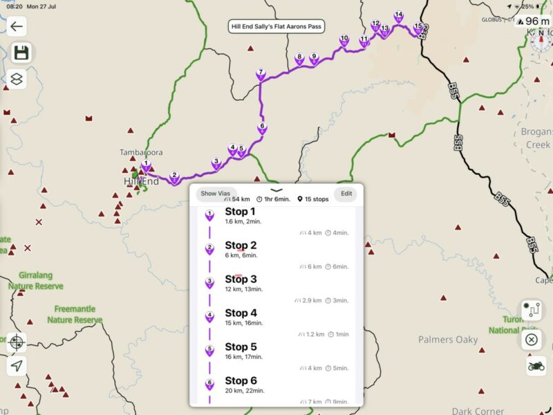
‘Scenic does it like this but you cannot step thru
I don’t want to go on a sales drive for Kurviger on this site. I’m committed to Scenic as Guido provides the best service and support of all
These Points have been raised and I know he is considering.
Kurviger does this very well and has two ways of viewing progress and cumulative time distance. This graph of the route showing sealed and dirt is great
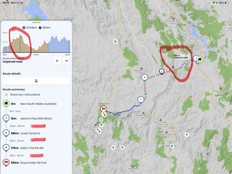
and this step by step through the waypoints is useful
‘Scenic does it like this but you cannot step thru
Quote from Dae on 27.07.2026, 00:46Quote from Old Man Emu on 26.07.2026, 16:32I don’t want to go on a sales drive for Kurviger on this site. I’m committed to Scenic as Guido provides the best service and support of all
These Points have been raised and I know he is considering.
Absolutely agreed, and I’ve not said anything I haven’t said directly to Guido via email.
I’d love a 100% Scenic solution, that’s not yet possible and so I need to use an alternative planer until such time as it is.
Scenic is by far the best navigator app. I have lifetime MRA, but never use it for navigating. Hopefully the planning in Scenic can get to that stage too. I’d love to ditch MRA entirely.
Quote from Old Man Emu on 26.07.2026, 16:32I don’t want to go on a sales drive for Kurviger on this site. I’m committed to Scenic as Guido provides the best service and support of all
These Points have been raised and I know he is considering.
Absolutely agreed, and I’ve not said anything I haven’t said directly to Guido via email.
I’d love a 100% Scenic solution, that’s not yet possible and so I need to use an alternative planer until such time as it is.
Scenic is by far the best navigator app. I have lifetime MRA, but never use it for navigating. Hopefully the planning in Scenic can get to that stage too. I’d love to ditch MRA entirely.


