Speed calculation tunnels when no GPS Satelite
Quote from Old Man Emu on 05.09.2024, 02:19I often ride a 15km tunnel section to get out of town. The North Connex Tunnel in Sydney, Australia. It is notorious for speed infringements for 82/83 in an 80 zone.
I set my cruise control to 79 to behave.
With Scenic the navigation understands that I'm in the North Connex Tunnel, the Here maps have the data and it rides along well through the tunnel. Older maps like my Car go crazy as the maps loaded in the car navigation are 9 years old when the tunnel did not exist.
So Scenic shows my speed as Zero as there is no GPS Satelite repeaters in the tunnel.
But Scenic knows my position in the tunnel and it knows the time. Therefore it could calculate distance and thus speed.
Has there been any work in a fall back speed calculation when there is no GPS signal ? It won't happen often but would be useful as it seems some Truck drivers have speed in the tunnel and would like to run up you hard.
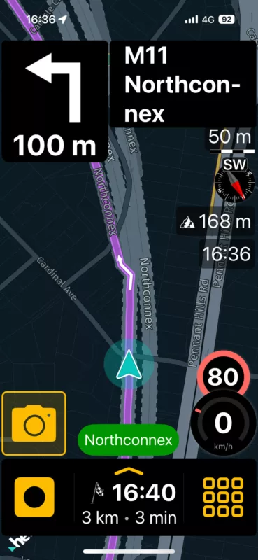
This photo show scenic moving me thru the tunnel and taking me to an exit.
I often ride a 15km tunnel section to get out of town. The North Connex Tunnel in Sydney, Australia. It is notorious for speed infringements for 82/83 in an 80 zone.
I set my cruise control to 79 to behave.
With Scenic the navigation understands that I'm in the North Connex Tunnel, the Here maps have the data and it rides along well through the tunnel. Older maps like my Car go crazy as the maps loaded in the car navigation are 9 years old when the tunnel did not exist.
So Scenic shows my speed as Zero as there is no GPS Satelite repeaters in the tunnel.
But Scenic knows my position in the tunnel and it knows the time. Therefore it could calculate distance and thus speed.
Has there been any work in a fall back speed calculation when there is no GPS signal ? It won't happen often but would be useful as it seems some Truck drivers have speed in the tunnel and would like to run up you hard.
This photo show scenic moving me thru the tunnel and taking me to an exit.
Quote from Guido on 05.09.2024, 07:04Your speed is provided by the GPS location that Scenic receives from iOS through your phone's built-in GPS receiver. As you are not receiving GPS coordinates while in a tunnel, your speed isn't known, and Scenic will display zero in those cases.
On the map, it might look like Scenic knows your location, but it doesn't. Your location on the map while in a tunnel, is an approximation. Honestly, I don't know the logic behind it (this is done by the HERE framework), but it has something to do with the speed you enter the tunnel, the speed limit in the tunnel, and perhaps it even uses motion sensors of your device to see when you accelerate and decelerate.
In other words, any speed that would be displayed while in a tunnel would be an approximation/estimate, and you wouldn't be able to rely on it to avoid speeding fines.
Your speed is provided by the GPS location that Scenic receives from iOS through your phone's built-in GPS receiver. As you are not receiving GPS coordinates while in a tunnel, your speed isn't known, and Scenic will display zero in those cases.
On the map, it might look like Scenic knows your location, but it doesn't. Your location on the map while in a tunnel, is an approximation. Honestly, I don't know the logic behind it (this is done by the HERE framework), but it has something to do with the speed you enter the tunnel, the speed limit in the tunnel, and perhaps it even uses motion sensors of your device to see when you accelerate and decelerate.
In other words, any speed that would be displayed while in a tunnel would be an approximation/estimate, and you wouldn't be able to rely on it to avoid speeding fines.


