Some small routing issues on my last trip
Quote from massi on 21.05.2023, 10:33Hi,
I just got home from a trip this weekend, on which I planned some routes with "Scenic" and saw some issues in every route, "Scenic" calculated (curvy fast, curvy, extra curvy).
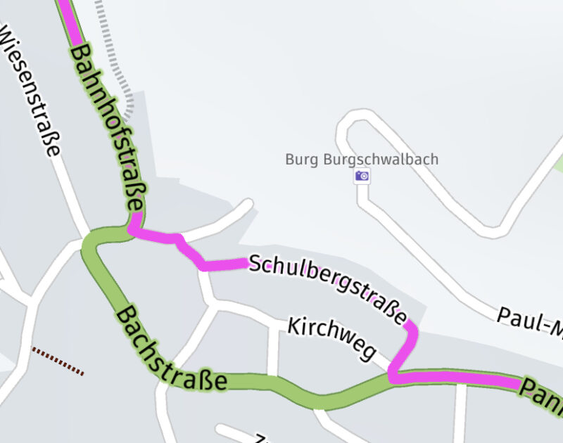
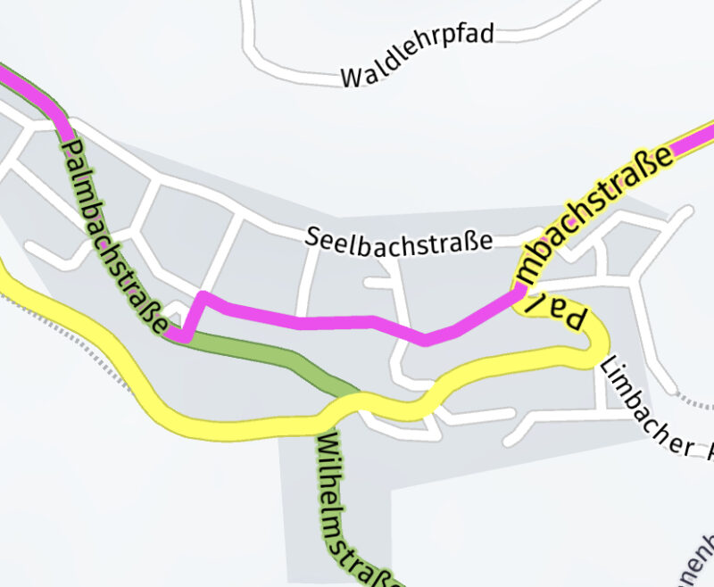
In some (small) villages it very often tried to shorten the main route, by routing me through very small roads, that were sometimes closed for vehicles or "traffic calmed". (see examples below) That was a little bit annoying, when I couldn't look far enough on the screen to see where the route will lastely go. One time it leaded me even through a pedestrian area.
I know, that the "Here maps" perhaps don't have the "don't pass"/"traffic calmed" characteristic saved and I can send this information to Here.
But on the last trip there were so many roads, where "Scenic" wanted me to drive through, that were not free for vehicles or "traffic calmed", that I can't believe that all these road characteristics are not saved in the "Here" maps. I saw this behaviour on former trips, but this weekend it was very often.
Perhaps it is a "problem" with the routing algorithm and it can be solved, I don't know.
Will it maybe solved with the new "Here" framework?
Regards
Marc-Antón
Hi,
I just got home from a trip this weekend, on which I planned some routes with "Scenic" and saw some issues in every route, "Scenic" calculated (curvy fast, curvy, extra curvy).
In some (small) villages it very often tried to shorten the main route, by routing me through very small roads, that were sometimes closed for vehicles or "traffic calmed". (see examples below) That was a little bit annoying, when I couldn't look far enough on the screen to see where the route will lastely go. One time it leaded me even through a pedestrian area.
I know, that the "Here maps" perhaps don't have the "don't pass"/"traffic calmed" characteristic saved and I can send this information to Here.
But on the last trip there were so many roads, where "Scenic" wanted me to drive through, that were not free for vehicles or "traffic calmed", that I can't believe that all these road characteristics are not saved in the "Here" maps. I saw this behaviour on former trips, but this weekend it was very often.
Perhaps it is a "problem" with the routing algorithm and it can be solved, I don't know.
Will it maybe solved with the new "Here" framework?
Regards
Marc-Antón
Quote from Guido on 21.05.2023, 11:54Hi Marc-Anton,
I understand. I experienced this myself in small villages in Mexico.
I do know that the new HERE framework has more data regarding this, but can’t say for sure if this will be a resolved in these specific cases.
Also, curvy routing works a bit different:
- First Kurviger provides via points to which the route must pass to make it curvy.
- These via points are fed through the HERE routing engine.
- For extra curvy routes Scenic tells the m HERE routing engine to use ‘short’ routing mode. For curvy and curvy fast Scenic tells it to use the ‘fast’ algorithm.
This last point is quite important and good have been the cause of these ‘unlucky’ choices. However, over time and through lots of feedback over the years I have found that matching extra curvy to ‘short’ and curvy + curvy fast to ‘fast’ typically works best. However there will always be exceptions.
Having said that, if HERE maps would have had the right data / would have known these roads were not allowed for motorized vehicles, then it would not have routes over these roads at all, no matter ‘short’ or ‘fast’
Hi Marc-Anton,
I understand. I experienced this myself in small villages in Mexico.
I do know that the new HERE framework has more data regarding this, but can’t say for sure if this will be a resolved in these specific cases.
Also, curvy routing works a bit different:
- First Kurviger provides via points to which the route must pass to make it curvy.
- These via points are fed through the HERE routing engine.
- For extra curvy routes Scenic tells the m HERE routing engine to use ‘short’ routing mode. For curvy and curvy fast Scenic tells it to use the ‘fast’ algorithm.
This last point is quite important and good have been the cause of these ‘unlucky’ choices. However, over time and through lots of feedback over the years I have found that matching extra curvy to ‘short’ and curvy + curvy fast to ‘fast’ typically works best. However there will always be exceptions.
Having said that, if HERE maps would have had the right data / would have known these roads were not allowed for motorized vehicles, then it would not have routes over these roads at all, no matter ‘short’ or ‘fast’
Quote from Mex on 22.05.2023, 04:51
Hi Folks.
Had this too last weekend in France.
Before we ended in a closed road and in neighbours garden i decided to turn.
What helped was to change the route calculation to: ignore next via while its mor than 2.5 kilometers behind you.
Regards Mex
Hi Folks.
Had this too last weekend in France.
Before we ended in a closed road and in neighbours garden i decided to turn.
What helped was to change the route calculation to: ignore next via while its mor than 2.5 kilometers behind you.
Regards Mex
Quote from massi on 11.09.2023, 11:27Hi,
I really hope, that the new Here framework has more data about roads that are closed for traffic. We were on a trip to czeszoslovakia last week, driving round the border to germany. Every day we had several roads that were closed for traffic or leads to unpassable dirt roads.
Regards
massi
Hi,
I really hope, that the new Here framework has more data about roads that are closed for traffic. We were on a trip to czeszoslovakia last week, driving round the border to germany. Every day we had several roads that were closed for traffic or leads to unpassable dirt roads.
Regards
massi


