Scenic 4.02 - routing is lousy
Quote from Sampleman on 13.10.2024, 03:46Hallo Guido, ich schreibe das auf deutsch (english version below)
Ich habe gerade auf Version 4.02 erneuert und mal probeweise eine Route geplant. Voreinstellungen: Motorrad, kurvig, Autobahnen und Mautstraßen vermeiden (powered by Kurviger.de).
Startpunkt: Zedlitzstraße, Augsburg (Ostrand des Stadtgebietes, direkt an der B2)
Zielpunkt: Dornbirn (Österreich), Stadtmitte (Stadtstraße gegenüber dem Kulturhaus)
Scenic berechnet eine Route von 205 km Länge, die an Langeweile nicht zu überbieten ist. Erst führt mich die Route durch ganz Augsburg, dann lande ich auf der Bundesstraße 300. Das Programm führt mich die die nächsten 80 km (!) immer entlang der B300, bis nach Heimertingen, da geht es dann weiter auf die B312. Die ganze Route führt mich durch Durchgangsstraßen und - wo vorhanden - über fette Bundesstraßen. Besonders kurvig ist da nix.
Ehrlich, dafür brauche ich kein Motorrad-Navi. Dafür brauche ich eigentlich überhaupt kein Navi.
Wenn ich dieselbe Strecke mit denselben Voreinstellungen (Kurvig, nicht extra kurvig) über den Webplaner von Kurviger.de berechnen lasse, kommt eine ganz andere Route dabei heraus. Sie ist mit 184 km etwas kürzer und verläuft insgesamt südlicher. Der Anteil an langweiligen Bundesstraßen ist viel, viel kleiner, die Strecke verläuft insgesamt über unterhaltsamere Straßen. Die B300 wird nicht genutzt.
Sogar Google Maps empfiehlt nicht, über die B300 zu fahren. Bei Google Maps ist der Anteil an langweiligen Bundesstraßen auch sehr hoch, dafür ist die Google-Route mit 175 km auch die kürzeste.
Mit anderen Worten: Scenic 4.02 kann noch überhaupt kein Routing, das den Ansprüchen an Motorradrouten erfüllt. Und was "powered by Kurviger" in diesem Zusammenhang bedeuten soll, erschließt sich mir nicht.
Wird es da noch Verbesserungen geben?
English translation:
I have just upgraded to version 4.02 and planned a route. Default settings: Motorcycle, curvy, avoid highways and toll roads (powered by Kurviger.de).
Starting point: Zedlitzstraße, Augsburg (eastern edge of the city, directly on the B2)
Destination: Dornbirn (Austria), city center (Stadtstraße opposite to the Kulturhaus)
Scenic calculates a route of 205 km in length, which cannot be surpassed in terms of boredom. First the route takes me through the whole of Augsburg, then I end up on the B300. The program takes me along the B300 for the next 80 km (!) until Heimertingen, where I continue on the B312. The whole route takes me through thoroughfares and - where available - over fat main roads. There's nothing particularly winding.
Honestly, I don't need a motorcycle navigation system for that. In fact, I don't need a satnav for that at all.
If I calculate the same route with the same default settings (curvy, not extra curvy) using the Kurviger.de web planner, I get a completely different route. At 184 km, it is slightly shorter and runs further south. The proportion of boring main roads is much, much smaller and the route runs along more entertaining roads. The B300 is not used.
Even Google Maps does not recommend taking the B300. Google Maps also has a very high proportion of boring main roads, but the Google route is also the shortest at 175 km.
In other words: Scenic 4.02 is not yet capable of routing that meets the requirements of motorcycle routes. And what “powered by Kurviger” is supposed to mean in this context is not clear to me.
Will there be any improvements in the near future?
Hallo Guido, ich schreibe das auf deutsch (english version below)
Ich habe gerade auf Version 4.02 erneuert und mal probeweise eine Route geplant. Voreinstellungen: Motorrad, kurvig, Autobahnen und Mautstraßen vermeiden (powered by Kurviger.de).
Startpunkt: Zedlitzstraße, Augsburg (Ostrand des Stadtgebietes, direkt an der B2)
Zielpunkt: Dornbirn (Österreich), Stadtmitte (Stadtstraße gegenüber dem Kulturhaus)
Scenic berechnet eine Route von 205 km Länge, die an Langeweile nicht zu überbieten ist. Erst führt mich die Route durch ganz Augsburg, dann lande ich auf der Bundesstraße 300. Das Programm führt mich die die nächsten 80 km (!) immer entlang der B300, bis nach Heimertingen, da geht es dann weiter auf die B312. Die ganze Route führt mich durch Durchgangsstraßen und - wo vorhanden - über fette Bundesstraßen. Besonders kurvig ist da nix.
Ehrlich, dafür brauche ich kein Motorrad-Navi. Dafür brauche ich eigentlich überhaupt kein Navi.
Wenn ich dieselbe Strecke mit denselben Voreinstellungen (Kurvig, nicht extra kurvig) über den Webplaner von Kurviger.de berechnen lasse, kommt eine ganz andere Route dabei heraus. Sie ist mit 184 km etwas kürzer und verläuft insgesamt südlicher. Der Anteil an langweiligen Bundesstraßen ist viel, viel kleiner, die Strecke verläuft insgesamt über unterhaltsamere Straßen. Die B300 wird nicht genutzt.
Sogar Google Maps empfiehlt nicht, über die B300 zu fahren. Bei Google Maps ist der Anteil an langweiligen Bundesstraßen auch sehr hoch, dafür ist die Google-Route mit 175 km auch die kürzeste.
Mit anderen Worten: Scenic 4.02 kann noch überhaupt kein Routing, das den Ansprüchen an Motorradrouten erfüllt. Und was "powered by Kurviger" in diesem Zusammenhang bedeuten soll, erschließt sich mir nicht.
Wird es da noch Verbesserungen geben?
English translation:
I have just upgraded to version 4.02 and planned a route. Default settings: Motorcycle, curvy, avoid highways and toll roads (powered by Kurviger.de).
Starting point: Zedlitzstraße, Augsburg (eastern edge of the city, directly on the B2)
Destination: Dornbirn (Austria), city center (Stadtstraße opposite to the Kulturhaus)
Scenic calculates a route of 205 km in length, which cannot be surpassed in terms of boredom. First the route takes me through the whole of Augsburg, then I end up on the B300. The program takes me along the B300 for the next 80 km (!) until Heimertingen, where I continue on the B312. The whole route takes me through thoroughfares and - where available - over fat main roads. There's nothing particularly winding.
Honestly, I don't need a motorcycle navigation system for that. In fact, I don't need a satnav for that at all.
If I calculate the same route with the same default settings (curvy, not extra curvy) using the Kurviger.de web planner, I get a completely different route. At 184 km, it is slightly shorter and runs further south. The proportion of boring main roads is much, much smaller and the route runs along more entertaining roads. The B300 is not used.
Even Google Maps does not recommend taking the B300. Google Maps also has a very high proportion of boring main roads, but the Google route is also the shortest at 175 km.
In other words: Scenic 4.02 is not yet capable of routing that meets the requirements of motorcycle routes. And what “powered by Kurviger” is supposed to mean in this context is not clear to me.
Will there be any improvements in the near future?
Quote from Aachener on 13.10.2024, 05:11Hallo Guido,
I've noticed that too. If I create a route, the generated route is the same, regardless of which route type I select. It looks to me as if the route is always generated with the 'Standard' setting. This applies to both 4.01 and 4.02. The web planner from kurviger.de delivers a completely different result.
Hallo Guido,
I've noticed that too. If I create a route, the generated route is the same, regardless of which route type I select. It looks to me as if the route is always generated with the 'Standard' setting. This applies to both 4.01 and 4.02. The web planner from kurviger.de delivers a completely different result.
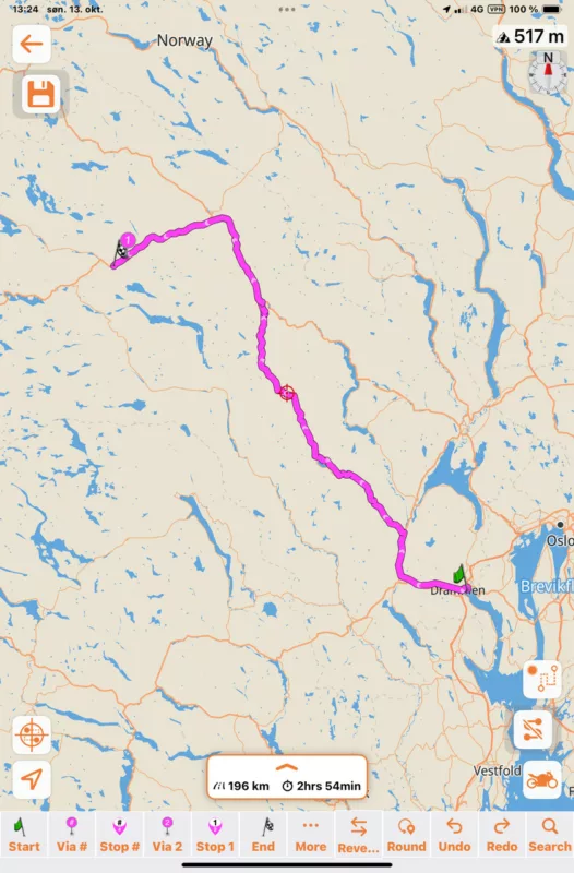
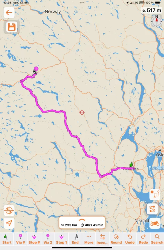
Quote from johansw on 13.10.2024, 05:38I was wondering if it is always like that. So I made a route from my home to the cottage. There are not too many roads in Norway, but some. What do you see below is that choosing 3 different options gave me 3 different roads. And looking closely at the chosen route, it is definitely the best choice according to specifications. I don’t know if it is different in the different countries, sounds impossible, but still possible? Anyway, this is the same result as I would get in scenic versions three, I guess.
Curvy road
S
Short road:
Standard road:
I was wondering if it is always like that. So I made a route from my home to the cottage. There are not too many roads in Norway, but some. What do you see below is that choosing 3 different options gave me 3 different roads. And looking closely at the chosen route, it is definitely the best choice according to specifications. I don’t know if it is different in the different countries, sounds impossible, but still possible? Anyway, this is the same result as I would get in scenic versions three, I guess.
Curvy road
S
Short road:
Standard road:
Quote from Joka on 13.10.2024, 12:02… also routing option SHORT makes no sense anymore. Even with AVOID UNPAVED you‘ll get ways directly thru fields (not even gravel). Hard to ride and vorbidden
Regards Joerg
… also routing option SHORT makes no sense anymore. Even with AVOID UNPAVED you‘ll get ways directly thru fields (not even gravel). Hard to ride and vorbidden
Regards Joerg
Quote from Aachener on 14.10.2024, 03:16I have just tested this again. If you plan a route (without via points or stops, no round trip) and then switch between the individual options, a route corresponding to the option is generated until the program automatically generates via points for the route. From then on, changing the route setting no longer has any effect on the generated route. This makes sense, as the via points determine the course of the route. The question is, why and when does the system automatically generate via points?
It looks as if the via points are generated as soon as I change the transportation mode. If I adjust only settings within a transportation mode, the via points are not generated and the route is adjusted according to the current settings.
I have just tested this again. If you plan a route (without via points or stops, no round trip) and then switch between the individual options, a route corresponding to the option is generated until the program automatically generates via points for the route. From then on, changing the route setting no longer has any effect on the generated route. This makes sense, as the via points determine the course of the route. The question is, why and when does the system automatically generate via points?
It looks as if the via points are generated as soon as I change the transportation mode. If I adjust only settings within a transportation mode, the via points are not generated and the route is adjusted according to the current settings.
Quote from Guido on 14.10.2024, 09:46Via points are generated for curvy and beauty routing (this is to force the route to take curvy/beauty roads). It's a bug that these via points are not removed if you choose another routing mode after that. Will be fixed in one of the upcoming update. For now, if you want to go back to a non-curvy routing mode, use the 'undo' button.
Via points are generated for curvy and beauty routing (this is to force the route to take curvy/beauty roads). It's a bug that these via points are not removed if you choose another routing mode after that. Will be fixed in one of the upcoming update. For now, if you want to go back to a non-curvy routing mode, use the 'undo' button.
Quote from Aachener on 15.10.2024, 04:55Ok, i can live with this workaround for a while. I think there are many other more important issues which have to be solved.
Ok, i can live with this workaround for a while. I think there are many other more important issues which have to be solved.


