Offroad Tracks
Quote from Deleted user on 20.05.2024, 09:13Hey all,
I think I have reached the limitations of the route planner in the app when it comes to offroad riding in my area. Most of the dirt/gravel here is illegal, but every now and again you come across some tracks that are not prohibited. They are usually not marked on any maps, at best they are sometimes on hiking maps or marked as fire roads etc.


I am wondering, what program I can use to create dirt/gravel tracks to then import the gpx into scenic, I am aware that it would only give me some kind of line navigation, which is fine... but I at least want to be able to create proper paths.
On another note, when is the feature "prefer unpaved roads" coming 😉 @guidomm?
Cheers from Bavaria,
Max
Hey all,
I think I have reached the limitations of the route planner in the app when it comes to offroad riding in my area. Most of the dirt/gravel here is illegal, but every now and again you come across some tracks that are not prohibited. They are usually not marked on any maps, at best they are sometimes on hiking maps or marked as fire roads etc.

I am wondering, what program I can use to create dirt/gravel tracks to then import the gpx into scenic, I am aware that it would only give me some kind of line navigation, which is fine... but I at least want to be able to create proper paths.
On another note, when is the feature "prefer unpaved roads" coming 😉 @guidomm?
Cheers from Bavaria,
Max
Quote from Guido on 20.05.2024, 10:00Hi Max,
You could try Furkot. They have a 'straight line' routing mode, and Scenic integrates nicely with it.
Or give the app Footpath a try. This app allows you to draw a line on the map with your finger. And you can export that as a GPX Track (premium feature). I have never really used it myself, but perhaps it's worth a try.
"prefer unpaved roads"... stay tuned 🙂.
Cheers,
Guido
Hi Max,
You could try Furkot. They have a 'straight line' routing mode, and Scenic integrates nicely with it.
Or give the app Footpath a try. This app allows you to draw a line on the map with your finger. And you can export that as a GPX Track (premium feature). I have never really used it myself, but perhaps it's worth a try.
"prefer unpaved roads"... stay tuned 🙂.
Cheers,
Guido
Quote from Deleted user on 20.05.2024, 11:08Thanks for the fast reply Guido, I tried out Furkot for a few minutes just now and it seems to do the trick. I'll do further field testing end of the week! 🙂
I am unbelievably excited for the "prefer unpaved roads" feature! I have had such nice rides just doing "fire & forget" routes with the app. Thank you for all your work and the constant updates... I am so happy I don't have to use 10 year old nav software anymore, I am slowly converting all of my friends.
Have a nice week!
Max
Thanks for the fast reply Guido, I tried out Furkot for a few minutes just now and it seems to do the trick. I'll do further field testing end of the week! 🙂
I am unbelievably excited for the "prefer unpaved roads" feature! I have had such nice rides just doing "fire & forget" routes with the app. Thank you for all your work and the constant updates... I am so happy I don't have to use 10 year old nav software anymore, I am slowly converting all of my friends.
Have a nice week!
Max
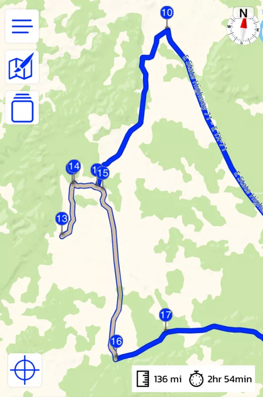
Quote from HyperMulti on 22.06.2024, 15:56So, I've used Footpath to create a route and imported it into Scenic. Will Scenic's turn-by-turn route me on this, including the u-turn? The grey section is all dirt. (I've changed the route colors to sort of match googles as that's what I'm used to vs the orange)
So, I've used Footpath to create a route and imported it into Scenic. Will Scenic's turn-by-turn route me on this, including the u-turn? The grey section is all dirt. (I've changed the route colors to sort of match googles as that's what I'm used to vs the orange)
Quote from HyperMulti on 22.06.2024, 16:02One feature addition would be a Cue Sheet to show the turns before having to do the ride.
The footpath cue sheet is pretty darn good (and I would use it for this type of ride if they had good CarPlay/Moto UI).
One feature addition would be a Cue Sheet to show the turns before having to do the ride.
The footpath cue sheet is pretty darn good (and I would use it for this type of ride if they had good CarPlay/Moto UI).
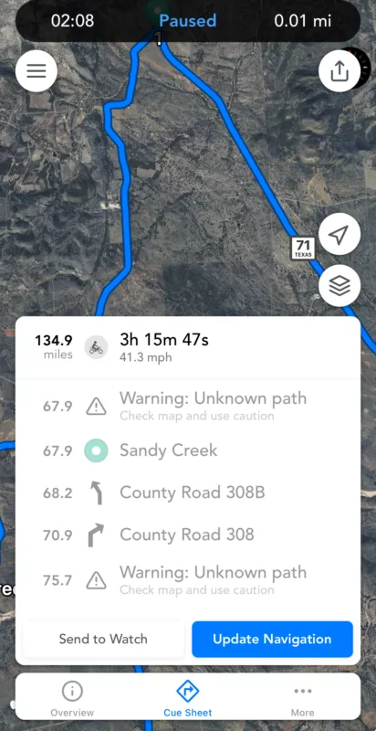
Quote from Guido on 22.06.2024, 16:11When you import it in Scenic, and can make the magenta line match the blue dotted line then, Scenic will guide you with tbt. Here’s more info: https://scenic.app/help/routes-vs-tracks-and-save-blue-line-as-track-during-import/
Working on a redesign for the fall. Cue sheet is on the list.
When you import it in Scenic, and can make the magenta line match the blue dotted line then, Scenic will guide you with tbt. Here’s more info: https://scenic.app/help/routes-vs-tracks-and-save-blue-line-as-track-during-import/
Working on a redesign for the fall. Cue sheet is on the list.
Quote from HyperMulti on 22.06.2024, 17:27Quote from Guido on 22.06.2024, 16:11When you import it in Scenic, and can make the magenta line match the blue dotted line then, Scenic will guide you with tbt. Here’s more info: https://scenic.app/help/routes-vs-tracks-and-save-blue-line-as-track-during-import/
Working on a redesign for the fall. Cue sheet is on the list.
Yes, I did that (no dotted line remaining). More wondering if it will do tbt on a road/route Scenic doesn't know. Not sure if that makes sense.
Quote from Guido on 22.06.2024, 16:11When you import it in Scenic, and can make the magenta line match the blue dotted line then, Scenic will guide you with tbt. Here’s more info: https://scenic.app/help/routes-vs-tracks-and-save-blue-line-as-track-during-import/
Working on a redesign for the fall. Cue sheet is on the list.
Yes, I did that (no dotted line remaining). More wondering if it will do tbt on a road/route Scenic doesn't know. Not sure if that makes sense.
Quote from Guido on 22.06.2024, 18:34The magenta line is the calculated line. If the route can be calculated over a specific road, you can get tbt on that road. In other words, you get tbt for magenta lines.
The magenta line is the calculated line. If the route can be calculated over a specific road, you can get tbt on that road. In other words, you get tbt for magenta lines.
Quote from HyperMulti on 27.06.2024, 09:23Quote from HyperMulti on 22.06.2024, 15:56So, I've used Footpath to create a route and imported it into Scenic. Will Scenic's turn-by-turn route me on this, including the u-turn? The grey section is all dirt. (I've changed the route colors to sort of match googles as that's what I'm used to vs the orange)
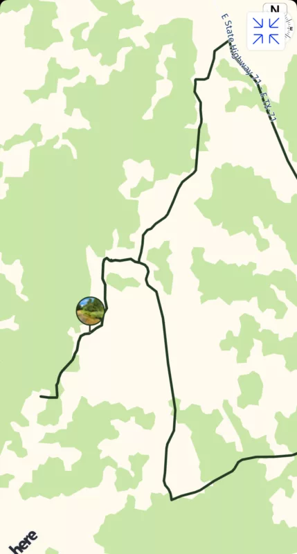
Quick follow-up - I did this ride yesterday, and Scenic did a perfect job routing me on the offroad sections I was worried about. I even went further down the trail than I thought I was going to, and Scenic didn't freak out, allowing me to keep going and make a u-turn when I was ready; it picked back up my next via point 14, and I was on my way in a very unfamiliar area with no signs. 🙂
You can see my route matches nearly perfectly the plan - the picture icon is where I thought I'd stop (via 13)
Quote from HyperMulti on 22.06.2024, 15:56So, I've used Footpath to create a route and imported it into Scenic. Will Scenic's turn-by-turn route me on this, including the u-turn? The grey section is all dirt. (I've changed the route colors to sort of match googles as that's what I'm used to vs the orange)
Quick follow-up - I did this ride yesterday, and Scenic did a perfect job routing me on the offroad sections I was worried about. I even went further down the trail than I thought I was going to, and Scenic didn't freak out, allowing me to keep going and make a u-turn when I was ready; it picked back up my next via point 14, and I was on my way in a very unfamiliar area with no signs. 🙂
You can see my route matches nearly perfectly the plan - the picture icon is where I thought I'd stop (via 13)
Quote from Guido on 27.06.2024, 09:55I'm happy to hear that! 🙂
I'm happy to hear that! 🙂
Quote from Helge on 12.09.2024, 03:45Hi Guido,
I also am eager to see the feature „prefer offroad paths“ to be implemented. Especially in the north east of Germany there are a lot of opportunities to legally ride non paved roads, but they are extremely hard to find. You have to zoom in very closely so these roads become visible and the usual navigation seems to avoid them at all costs.
Keep up the good work. I love to see how active the community is, how frequent and transparent your communication is and how much you care!
Thank you!
Hi Guido,
I also am eager to see the feature „prefer offroad paths“ to be implemented. Especially in the north east of Germany there are a lot of opportunities to legally ride non paved roads, but they are extremely hard to find. You have to zoom in very closely so these roads become visible and the usual navigation seems to avoid them at all costs.
Keep up the good work. I love to see how active the community is, how frequent and transparent your communication is and how much you care!
Thank you!


