Bizarre Routing via UK from Northern Spain
Quote from KM on 15.02.2025, 17:58I have just imported 12 routes created on Basecamp. I have done this successfully many times before the new Map provider.
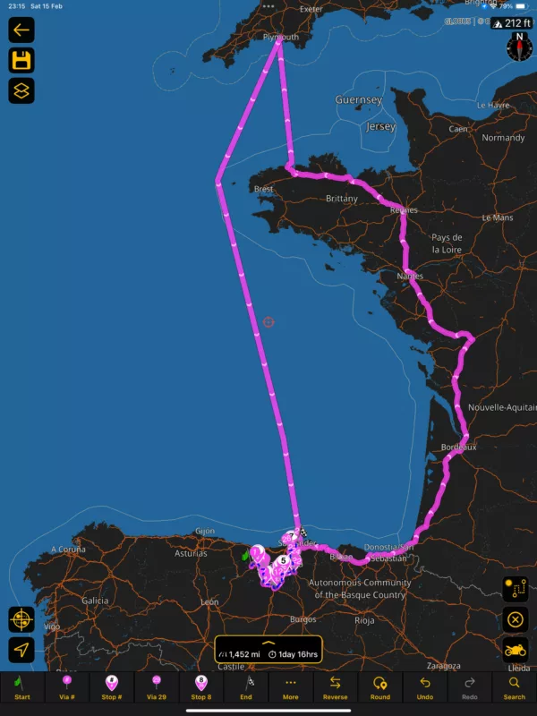
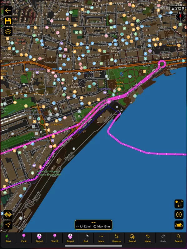
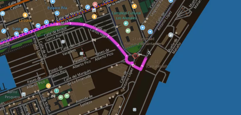
Within 2 miles of the Santander Ferry Terminal, the algorithm wants to take me through France, across the English Channel, and back to Santander via another ferry to get to the Santander Port a detour of 1301 miles!!
I've tried adding "vias" and moving the finish point but just can't get to the Ferry terminal without a 2 Ferry detour.
Happy to send the gpx if this helps and in case I am doing something stupid.
This App worked so well before the new map provider, had become my primary Navigation source and was far better and reliable than my Nav VI. Sadly this no longer the case.
Any ideas / suggestions?
Kevin
Kevin
I have just imported 12 routes created on Basecamp. I have done this successfully many times before the new Map provider.
Within 2 miles of the Santander Ferry Terminal, the algorithm wants to take me through France, across the English Channel, and back to Santander via another ferry to get to the Santander Port a detour of 1301 miles!!
I've tried adding "vias" and moving the finish point but just can't get to the Ferry terminal without a 2 Ferry detour.
Happy to send the gpx if this helps and in case I am doing something stupid.
This App worked so well before the new map provider, had become my primary Navigation source and was far better and reliable than my Nav VI. Sadly this no longer the case.
Any ideas / suggestions?
Kevin
Kevin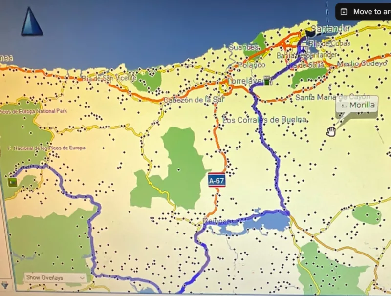
Quote from Guido on 15.02.2025, 18:46Yes. Please send me the GPX
Yes. Please send me the GPX
Quote from Dae on 16.02.2025, 01:20I can see the logic here, if I’m not mistaken.
Your finish flag is right where the ferry departs from, and all roads to get to it are marked as “private access” in OSM. Therefore taking the ferry would land you on the other side of the private access roads and allow you to reach your destination, even if it is the very long way round.
I always put the flag at the entrance to the terminal, and it works fine for the trip I have planned for June. After all, you don’t need guidance all the way to the boat - the border security workers in the terminal will take care of that😀
I can see the logic here, if I’m not mistaken.
Your finish flag is right where the ferry departs from, and all roads to get to it are marked as “private access” in OSM. Therefore taking the ferry would land you on the other side of the private access roads and allow you to reach your destination, even if it is the very long way round.
I always put the flag at the entrance to the terminal, and it works fine for the trip I have planned for June. After all, you don’t need guidance all the way to the boat - the border security workers in the terminal will take care of that😀
Quote from johansw on 16.02.2025, 03:58That was an informative and useful reply!! Helps me understand a couple of similar situations!
But how do you se that streets are «private access»?
That was an informative and useful reply!! Helps me understand a couple of similar situations!
But how do you se that streets are «private access»?
Quote from KM on 16.02.2025, 06:10Having spent some time editing the route and shifting the finish flag along the last 2 miles to see what happened, I am sure Dae's explanation is correct.
I parked the flag at the barrier on the road into the port and the route stopped at the gate without the 1301 mile detour. I've sailed from Santander lots of times and with Garmin Basecamp you can end at the ferry ramp without any issues. The street view was helpful as I could look at the familiar landmarks and can confirm the error starts as soon as you enter the "private" port roads.
Lesson learnt.
Guido - I've not sent the gpx file as I am sure this is the explanation.
Kevin
Having spent some time editing the route and shifting the finish flag along the last 2 miles to see what happened, I am sure Dae's explanation is correct.
I parked the flag at the barrier on the road into the port and the route stopped at the gate without the 1301 mile detour. I've sailed from Santander lots of times and with Garmin Basecamp you can end at the ferry ramp without any issues. The street view was helpful as I could look at the familiar landmarks and can confirm the error starts as soon as you enter the "private" port roads.
Lesson learnt.
Guido - I've not sent the gpx file as I am sure this is the explanation.
Kevin
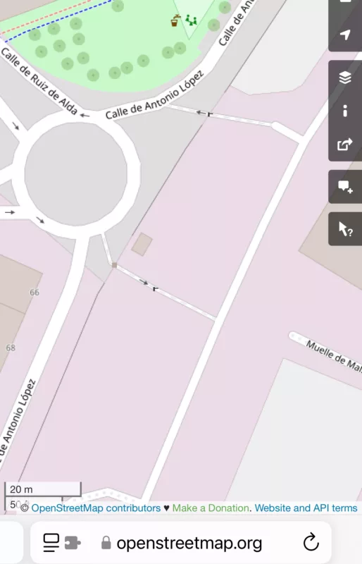
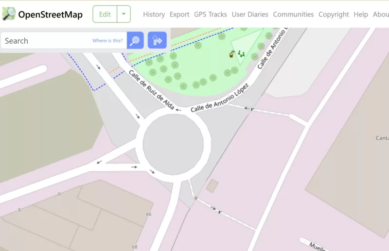
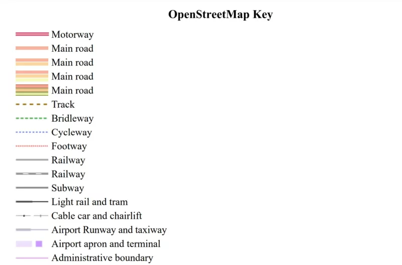
Quote from KM on 16.02.2025, 06:25On the OSM key the faint purple line is the "Administrative Boundary" and the faint purple "Airport Apron / Terminal"
In Scenic the line is brown / pink and the private land black. I could get the finish slightly into the port beyond the barrier on the map.
Kevin
On the OSM key the faint purple line is the "Administrative Boundary" and the faint purple "Airport Apron / Terminal"
In Scenic the line is brown / pink and the private land black. I could get the finish slightly into the port beyond the barrier on the map.
Kevin
Quote from Dae on 16.02.2025, 12:38Quote from johansw on 16.02.2025, 03:58That was an informative and useful reply!! Helps me understand a couple of similar situations!
But how do you se that streets are «private access»?
Honestly, it was local knowledge that I checked on the open street map website in the screenshot as I didn’t have Scenic on the device I was using. You can (only just) see the grey dashes on the entry road, which the key says means private access.
Quote from johansw on 16.02.2025, 03:58That was an informative and useful reply!! Helps me understand a couple of similar situations!
But how do you se that streets are «private access»?
Honestly, it was local knowledge that I checked on the open street map website in the screenshot as I didn’t have Scenic on the device I was using. You can (only just) see the grey dashes on the entry road, which the key says means private access.
Quote from Guido on 16.02.2025, 12:53You can also check on openstreetmap.org. If you zoom in close enough you can query features of a road.
You can also check on openstreetmap.org. If you zoom in close enough you can query features of a road.


