Weird routing
Quote from Dae on 04.03.2025, 16:41Hi @guidomm,
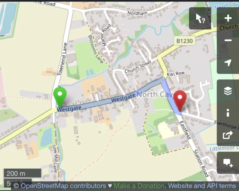
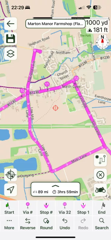
I’m getting weird routing in this route around points 10-12. I’ve checked on openstreetmap, Google and Apple but can’t figure out what’s happening. It’s a single straight road from 10 to 11, then a right turn to 12, but Scenic wants to put a weird detour in.
The route is here (I’ve cut the start for privacy)
https://scenicapp.space/route/piMUovWL
Hi @guidomm,
I’m getting weird routing in this route around points 10-12. I’ve checked on openstreetmap, Google and Apple but can’t figure out what’s happening. It’s a single straight road from 10 to 11, then a right turn to 12, but Scenic wants to put a weird detour in.
The route is here (I’ve cut the start for privacy)
https://scenicapp.space/route/piMUovWL
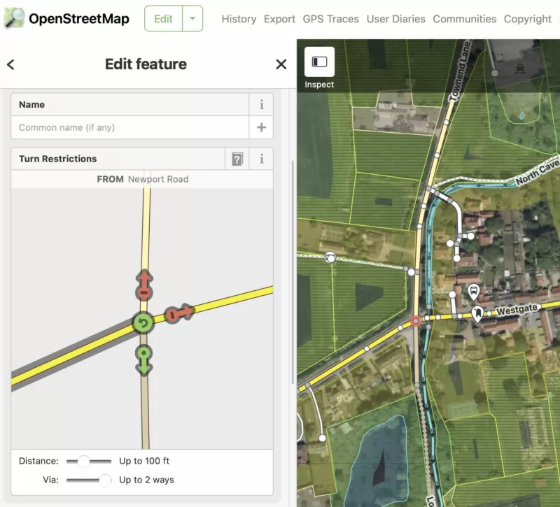
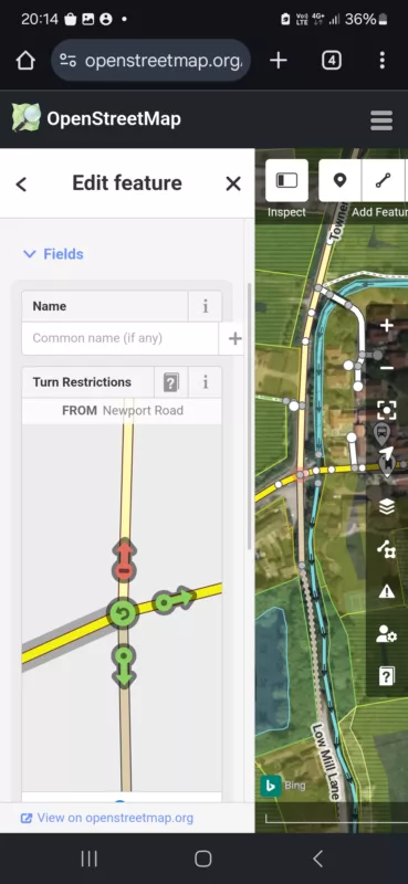
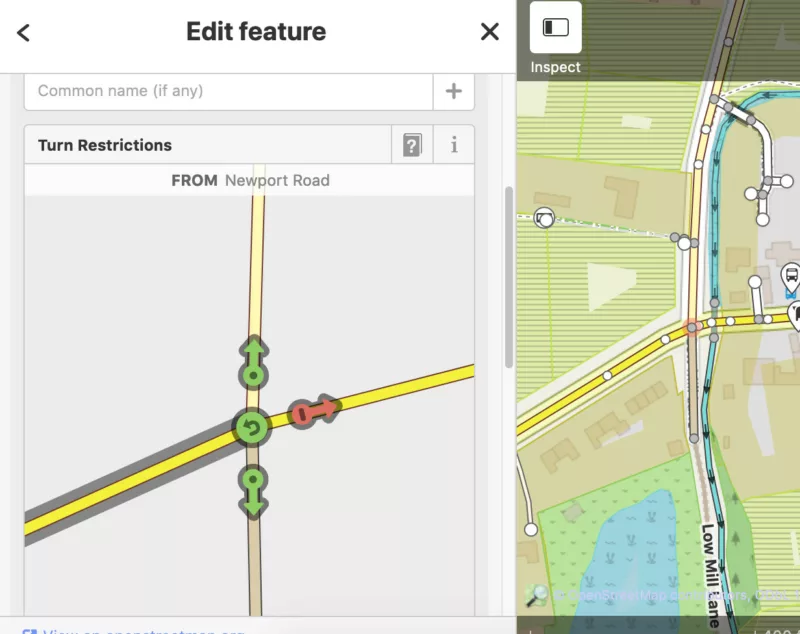
Quote from Guido on 04.03.2025, 17:20The junction just after via 10 has turn restrictions in OpenStreetMap:
https://www.openstreetmap.org/edit?way=9215913#map=17/53.779284/-0.649052 (you have to go to "edit" mode on OpenStreetMap.org to see this)
The junction just after via 10 has turn restrictions in OpenStreetMap:
https://www.openstreetmap.org/edit?way=9215913#map=17/53.779284/-0.649052 (you have to go to "edit" mode on OpenStreetMap.org to see this)
Quote from KM on 04.03.2025, 17:22Coincidentally I live in Walkington and have struggled to get home from the North Cave Motorway junction. There are no turn restrictions on the live roads.
Kevin
Coincidentally I live in Walkington and have struggled to get home from the North Cave Motorway junction. There are no turn restrictions on the live roads.
Kevin
Quote from Guido on 04.03.2025, 17:27@dae. Your first screenshot (with the route/green/red marker) is from a different road if I'm not mistaken.
@dae. Your first screenshot (with the route/green/red marker) is from a different road if I'm not mistaken.
Quote from Dae on 04.03.2025, 17:32Quote from Guido on 04.03.2025, 17:27@dae. Your first screenshot (with the route/green/red marker) is from a different road if I'm not mistaken.
I posted the correct one afterwards
Quote from Guido on 04.03.2025, 17:27@dae. Your first screenshot (with the route/green/red marker) is from a different road if I'm not mistaken.
I posted the correct one afterwards
Quote from Guido on 04.03.2025, 17:34Ok. I see. If you place the start marker left of the junction I suspect you’ll get a similar loop.
Ok. I see. If you place the start marker left of the junction I suspect you’ll get a similar loop.
Quote from Dae on 04.03.2025, 17:36I tried looking in OSM originally, but didn’t realise you had to be in edit mode to see turn restrictions.
In reality there’s no turn restriction there, just a prohibition for HGVs. The route is fine in Google, Apple and using OSM in MyRouteApp
I tried looking in OSM originally, but didn’t realise you had to be in edit mode to see turn restrictions.
In reality there’s no turn restriction there, just a prohibition for HGVs. The route is fine in Google, Apple and using OSM in MyRouteApp
Quote from Dae on 04.03.2025, 17:39Quote from Guido on 04.03.2025, 17:34Ok. I see. If you place the start marker left of the junction I suspect you’ll get a similar loop.
Yes. It does. I think OSM is reading the prohibition for HGVs as nobody being allowed to go straight on, which is incorrect.
Quote from Guido on 04.03.2025, 17:34Ok. I see. If you place the start marker left of the junction I suspect you’ll get a similar loop.
Yes. It does. I think OSM is reading the prohibition for HGVs as nobody being allowed to go straight on, which is incorrect.
Quote from Guido on 04.03.2025, 17:45I don’t know if you can limit turn restrictions to vehicle type in OSM. I don’t see this limitation on OSM. I’ll take a more detailed look tomorrow.
I don’t know if you can limit turn restrictions to vehicle type in OSM. I don’t see this limitation on OSM. I’ll take a more detailed look tomorrow.
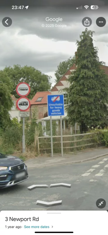
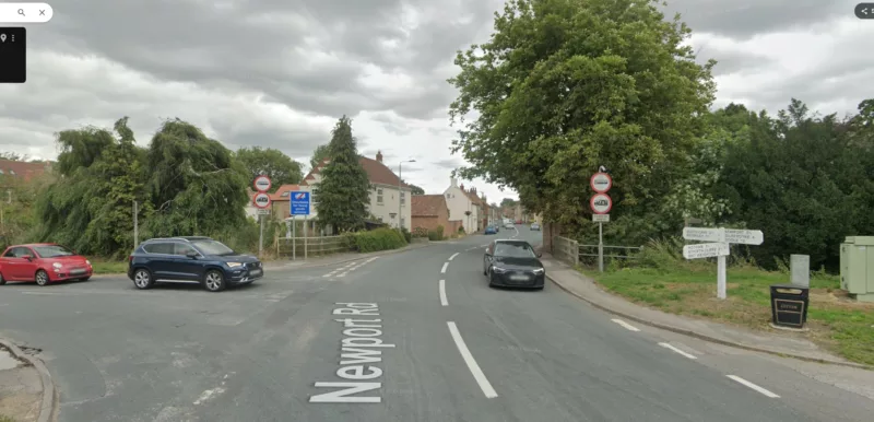
Quote from Dae on 04.03.2025, 17:47The limitation is easiest to see if you street view the junction. You can see the signs saying HGVs limited etc.
The limitation is easiest to see if you street view the junction. You can see the signs saying HGVs limited etc.
Quote from Guido on 04.03.2025, 17:50I see. This needs to be corrected in OSM. If it is possible to limit the turn restrictions to HGV vehicles that would be great, but I’m not sure that’s possible. Otherwise remove the limitation altogether. I’ll look into it tomorrow.
I see. This needs to be corrected in OSM. If it is possible to limit the turn restrictions to HGV vehicles that would be great, but I’m not sure that’s possible. Otherwise remove the limitation altogether. I’ll look into it tomorrow.
Quote from Guido on 04.03.2025, 20:18Did somebody just correct this? Now I only see a turn restriction for going left.
https://www.openstreetmap.org/node/26014871 (only one relation. Before there were 2)
Did somebody just correct this? Now I only see a turn restriction for going left.
https://www.openstreetmap.org/node/26014871 (only one relation. Before there were 2)
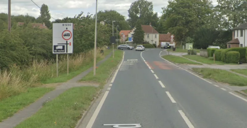
Quote from KM on 05.03.2025, 03:04I was wrong, there is a restriction for large lorries into North Cave except for deliveries as per the pictures below.
There is a tight right hand bend further into the village that would be impossible for an HGV. Its hard enough in a large car at times depending upon how people position at the junction and where cars are left parked.
When I was thrown by this Scenic wanted to send me on a 67 mile detour rather than the 8 or so miles to home which is more or less the crow flies.
Kevin
I was wrong, there is a restriction for large lorries into North Cave except for deliveries as per the pictures below.
There is a tight right hand bend further into the village that would be impossible for an HGV. Its hard enough in a large car at times depending upon how people position at the junction and where cars are left parked.
When I was thrown by this Scenic wanted to send me on a 67 mile detour rather than the 8 or so miles to home which is more or less the crow flies.
Kevin
Quote from mattsz on 05.03.2025, 04:53Quote from Guido on 04.03.2025, 20:18Did somebody just correct this? Now I only see a turn restriction for going left.
https://www.openstreetmap.org/node/26014871 (only one relation. Before there were 2)
Just for kicks, I went to view the same intersection. Gotta wonder:
Quote from Guido on 04.03.2025, 20:18Did somebody just correct this? Now I only see a turn restriction for going left.
https://www.openstreetmap.org/node/26014871 (only one relation. Before there were 2)
Just for kicks, I went to view the same intersection. Gotta wonder:
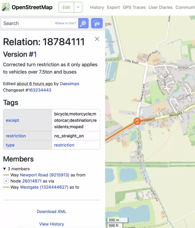
Quote from Dae on 05.03.2025, 06:55I made a change in OSM this morning. You can’t say what a restriction applies to, but you can add exceptions. I made the exceptions for everything except HGV and bus, which reflects reality more accurately.
I made a change in OSM this morning. You can’t say what a restriction applies to, but you can add exceptions. I made the exceptions for everything except HGV and bus, which reflects reality more accurately.
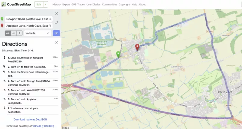
Quote from Guido on 05.03.2025, 09:14This is becoming a long topic, but I think it's important. For me this is also a learning experience with OpenStreetMaps.
So, @dae. I see what you did:
When I try a routing with the Valhalla routing engine (that's the one that Scenic's map provider is using), though, it's not working (yet??).
This could be for 2 reasons:
1). Valhalla is ignoring the "except" field. That would be bad.
Some background: The way Valhalla (and other OSM routing engines) work, is as follows. They take a data extract from OSM, and convert that into another data format / database that is optimized for fast route calculation. It is possible (I don't know), that the except field is ignored during this conversion and/or during the route calculation itself.
2) The routing on OSM is still running on old OSM data that does not contain your change. I took a look FOSSGIS (which is the Valhalla server that is used by the openstreetmap site.) here: https://valhalla.openstreetmap.de/, At the bottom you can see that the latest data extract is from march 5, 9:11 am. (As FOSSGIS is german based I assume this is german time). @Dae, you made your change at 8:42 GMT (which is 9:42 in Germany). This seems to suggest that indeed you did your change after FOSSGISS took it's latest extract.
I suggest following: we keep an eye on FOSSGIS to see when they take a new extract (I suspect they do this once a day). After they took the new extract, we try the route calculation again. If it now works, we can say with relative certainty that this will also be handled by Scenic's map provider once the next map update is released. If, however, the route still calculates wrong, then very likely the "except" field is ingored and it would be better to remove the restriction altogether.
Hope I'm making sense 🙂.
Cheers and thank you!,Guido
This is becoming a long topic, but I think it's important. For me this is also a learning experience with OpenStreetMaps.
So, @dae. I see what you did:
When I try a routing with the Valhalla routing engine (that's the one that Scenic's map provider is using), though, it's not working (yet??).
This could be for 2 reasons:
1). Valhalla is ignoring the "except" field. That would be bad.
Some background: The way Valhalla (and other OSM routing engines) work, is as follows. They take a data extract from OSM, and convert that into another data format / database that is optimized for fast route calculation. It is possible (I don't know), that the except field is ignored during this conversion and/or during the route calculation itself.
2) The routing on OSM is still running on old OSM data that does not contain your change. I took a look FOSSGIS (which is the Valhalla server that is used by the openstreetmap site.) here: https://valhalla.openstreetmap.de/, At the bottom you can see that the latest data extract is from march 5, 9:11 am. (As FOSSGIS is german based I assume this is german time). @Dae, you made your change at 8:42 GMT (which is 9:42 in Germany). This seems to suggest that indeed you did your change after FOSSGISS took it's latest extract.
I suggest following: we keep an eye on FOSSGIS to see when they take a new extract (I suspect they do this once a day). After they took the new extract, we try the route calculation again. If it now works, we can say with relative certainty that this will also be handled by Scenic's map provider once the next map update is released. If, however, the route still calculates wrong, then very likely the "except" field is ingored and it would be better to remove the restriction altogether.
Hope I'm making sense 🙂.
Cheers and thank you!,
Guido
Quote from Dae on 05.03.2025, 09:21That makes perfect sense. The reason I didn’t remove the restriction completely is I’m mindful that other services/apps will use OSM data and could be effected by us fixing a “Scenic/Valhalla” specific issue. For example, if someone has a GPS that’s dedicated for HGV drivers (my friend has such a device as she drives one) then if we remove the restriction they could be adversely affected (if they are OSM based).
Hope that makes sense. I changed the title of the thread as I initially thought this was a 4.14 issue as it only appeared when I upgraded (at the time the route preview in routes list didn’t show the loop, but when I went into edit mode it appeared).
That makes perfect sense. The reason I didn’t remove the restriction completely is I’m mindful that other services/apps will use OSM data and could be effected by us fixing a “Scenic/Valhalla” specific issue. For example, if someone has a GPS that’s dedicated for HGV drivers (my friend has such a device as she drives one) then if we remove the restriction they could be adversely affected (if they are OSM based).
Hope that makes sense. I changed the title of the thread as I initially thought this was a 4.14 issue as it only appeared when I upgraded (at the time the route preview in routes list didn’t show the loop, but when I went into edit mode it appeared).
Quote from Guido on 05.03.2025, 09:25Yes... I agree that putting in the except tag is the best way as it would work for all vehicle types. However,... if it's option 1 that I mentioned above, then I still vote for removing the restriction... simply because of the number of people affected by wrong routing. (more cars/motorcycles than HGV's). But, we are getting ahead of ourselves. I have a slight hope that it's going to be option 2. Fingers crossed 🙂.
Yes... I agree that putting in the except tag is the best way as it would work for all vehicle types. However,... if it's option 1 that I mentioned above, then I still vote for removing the restriction... simply because of the number of people affected by wrong routing. (more cars/motorcycles than HGV's). But, we are getting ahead of ourselves. I have a slight hope that it's going to be option 2. Fingers crossed 🙂.
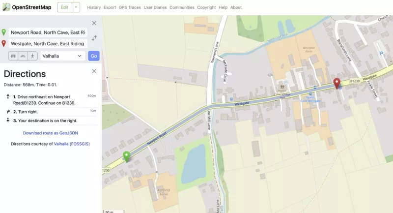
Quote from Guido on 06.03.2025, 17:17Your correction works @dae. So... now we just have to wait for the next map update from Scenic's map provider.
Your correction works @dae. So... now we just have to wait for the next map update from Scenic's map provider.
Quote from KM on 07.03.2025, 00:59Are there instructions somewhere on how to edit OSM. I registered to edit but can’t see what to do!?
Kevin
Are there instructions somewhere on how to edit OSM. I registered to edit but can’t see what to do!?
Kevin
Quote from mattsz on 07.03.2025, 05:18Quote from KM on 07.03.2025, 00:59Are there instructions somewhere on how to edit OSM. I registered to edit but can’t see what to do!?
Kevin
I've actually done it twice, and I still don't know how...
Quote from KM on 07.03.2025, 00:59Are there instructions somewhere on how to edit OSM. I registered to edit but can’t see what to do!?
Kevin
I've actually done it twice, and I still don't know how...


